
Sac-Crawford-Carroll-Audubon-Guthrie

...WINTER WEATHER ADVISORY NOW IN EFFECT FROM 1 AM TO 7 PM CDT
WEDNESDAY...

* WHAT...Mixed precipitation expected. Total snow accumulations of
  2 to 5 inches, with localized higher amounts closer to Highway
  20. Ice accumulations of up to one tenth of an inch are also
  possible, mainly along the Highway 30 corridor.

* WHERE...Portions of west central and central Iowa.

* WHEN...From 1 AM to 7 PM CDT Wednesday.

* ADDITIONAL DETAILS...The mixed precipitation will result in
  difficult travel conditions, including during the morning
  commute on Wednesday. Expect reduced visibilities at times,
  especially during heavier snowfall.
Monona
...WINTER WEATHER ADVISORY IN EFFECT FROM 1 AM TO 1 PM CDT
WEDNESDAY...

* WHAT...Mixed precipitation expected. Total snow accumulations
  of 1 to 3 inches and ice accumulations of up to one tenth of
  an inch are expected.

* WHERE...Portions of east central and northeast Nebraska and
  west central Iowa.

* WHEN...From 1 AM to 1 PM CDT Wednesday.

* ADDITIONAL DETAILS...The ice will result in difficult travel
  conditions, including during the morning commute on Wednesday.
  Expect reduced visibilities at times.
Sac-Crawford and Carroll Counties in the KJAN listening area…
A WINTER WEATHER ADVISORY WILL BE IN EFFECT FROM 1 AM TO 10 PM CDT WEDNESDAY…
Mixed precipitation expected. Total snow accumulations of 2 to 4 inches, and ice accumulations of up to one tenth of an inch are expected. Snowfall rates may approach an inch per hour Wednesday during periods of heavy snowfall. The ice will result in difficult travel conditions, including during the morning commute on Wednesday. Expect reduced visibilities at times.
PRECAUTIONARY/PREPAREDNESS ACTIONS…
A Winter Weather Advisory means that periods of snow, sleet or freezing rain will cause travel difficulties. Expect slippery roads and limited visibilities, and use caution while driving.
The latest road conditions for the state you are calling from can be obtained by calling 5 1 1.
Today: Increasing clouds. High 52. SE @ 10-20.
Tonight: Cloudy w/light rain becoming mixed w/& changing to snow. Low 34. E @ 10-20.
Tomorrow: Cldy w/a mix of snow-rain in the morning. High 38. N/NE @ 15-30.
Thursday: P/Cldy. High near 50.
Friday: P/Cldy. High 55.
Monday’s High in Atlantic was 45. Our Low 21. Last year on this date, the High was 73 and the Low was 41. The Record High in Atlantic on April 17th was 85 in 2004, and the Record Low was 11 in 1907.
Today: P/cloudy to cldy this morning; P/Cldy this aft. High 43. NW @ 10-20mph.
Tonight: P/Cldy. Low 26. E @ 5-10.
Tomorrow: Mo. Cldy. High 53. SE @ 15-25.
Wednesday: Cldy w/a rain-snow mix in the morning. High 40.
Thursday: P/Cldy. High 54.
Sunday’s High in Atlantic was 31. Our Low was 21. We had intermittent snow flurries yesterday (Trace of precipitation). Last year on this date our High was 73 and the Low was 40. The record High in Atlantic on this date was 88 in 1898. The Record Low was 19, in 1988.
Today: Cloudy & windy w/a 60% chance of snow, mainly before 9am. Patchy blowing snow. High near 32. N/NW winds 15-35mph. New snow accumulation of less than a half inch possible.
Tonight: Cloudy w/patchy blowing snow before 9pm. Gradually becoming partly cloudy. Low around 22. N/NE @ 15-30mph.
Monday: Sunny, with a high near 43. NW wind 10-20mph.
Monday Night: Clear. Low around 24.
Tuesday: Mostly sunny, with a high near 54.
Tuesday Night: Cloudy & breezy, w/a 40 percent chance of rain. Low around 37.
Wednesday: Cloudy & windy, w/a 40% chance of rain in the morning & again during the afternoon. High near 48.
Wednesday Night: Mostly cloudy & windy, with a low around 30.
Thursday: Mostly sunny, with a high near 50.
We received .3″ of snow overnight here in Atlantic, at the KJAN Studios (as of 6-a.m.). There was also some freezing rain/drizzle Saturday afternoon. Total (melted and liquid) precip. amounted to .07″. Our High yesterday in Atlantic was 38. The Low this morning 23. Last year on this date, our High in Atlantic was 74 and the Low was 46. The Record High in Atlantic on this date was 84 in 1920 and the Record Low was 17 in 1926 & 1962.
Skyscan Forecast Saturday, April 14, 2018 Richard Garuckas
Today: Cloudy. Snow mixing with rain and freezing rain at times. High 37. NNE @ 20-25, gusting to 35.
Tonight: Cloudy. Snow early, then gradual clearing. Low 24. Windy. N @ 15-25, gusting to 25. Snow accumulations of 1 to 3 inches.
Sunday: Cloudy. Slight chance of snow showers in the morning. High 34. Breezy. NNW @ 15-25, gusting to 30.
Sunday Night: Mostly cloudy. Low 23.
Monday: Mostly sunny. High 45.
Tuesday: Partly cloudy. Warmer. High 57.
Wednesday: Mostly cloudy. High 49.

Podcast: Play in new window | Download (768.5KB)
Subscribe: RSS
High winds, unconfirmed tornadoes, hail and heavy rain wreaked havoc on parts of western and central Iowa, Friday. The National Weather Service says winds in excess of 60-miles per hour caused damage in parts of Cass County.
At around 4:25-p.m., thunderstorm wind damage was reported to outbuildings, 3-miles south/southwest of Marne, Five-minutes later, a 61-mile per hour wind was recorded by an automated weather system, two-miles west/northwest of Atlantic. At around 4:30-p.m., a camper was reported blown over 4-miles southeast of Brayton. There were also media reports of damage to outbuildings and a barn located between Highway 173 and 71, and substantial damage to 5th wheel RV trailers just north of I-80 and the Olive Street exit.
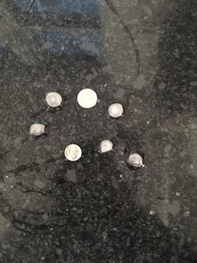
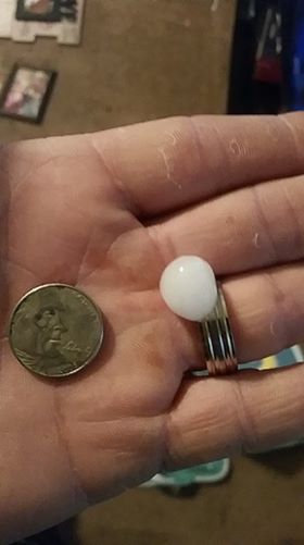
Prior to the line of storms entering Cass County, they fired-up to our southwest. At around 3:15-p.m., one-half inch diameter (marble size) hail was reported near Shelby…nickel-size hail fell in Avoca at around 3:22-p.m….Walnut size (1.5” diameter) hail fell just southeast of Oakland at around 3:53-p.m. Golf ball size hail (1.75” dia.) was reported near Henderson and Oakland at a little after 4-p.m., with egg-size hail reported to have fallen 5-miles east of Henderson. Some video footage seen on social media indicated there may have been weak tornadoes in parts of northern Cass County Friday afternoon, but that has not yet been confirmed by the Weather Service.
Quarter-size hail fell in Walnut at around 4:15-p.m. Golf ball size hail fell near Essex at around 6:40-p.m., and penny-size hail was reported near Villisca, about 5-minutes later. Nickel-size hail was reported at around 3:50-p.m., in Denison. Guthrie Center received quarter-size hail at around 6:25-p.m. Dime-to quarter-size hail was reported between Gravity and Sharpsburg, in Taylor County, from 7:40-to 7:55-p.m.
South of Creston, winds gusted to a little more than 50-miles per hour, as the storms were moving northeast and out of the listening area, at around 8:15-p.m. Across Iowa, a home was damaged in Hubbard, a semi was blown over on I-35 near Roland, power lines were down in Story City, hail covered the ground in Churdan, multiple buildings were damaged, and large campers were flipped over in Jefferson, and hail caused broken windows in/near Scranton.
Here are some pictures submitted to KJAN from our Facebook contributors following today’s severe storms. Thanks to all who sent in their submissions!
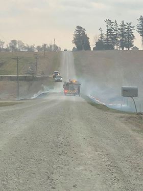
This is the area near the Atlantic School’s bus barn, where a grass fire was sparked from a broken power line Friday afternoon, at around 4-p.m. The power was restored within about 35-minutes. (Photo courtesy Kyle Hansen)
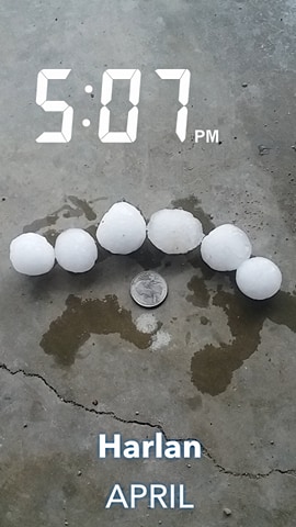
Emily Emealia Watts – Harlan
Joel Schlueter – Elk Horn
Amanda Marhloz -Walnut
Iowans have enjoyed weather conditions the past couple days that are more typical for mid-April, but a return to winter is right around the corner. Highs will be climbing into the 70s in some areas this afternoon, before rain and snow move in tonight. National Weather Meteorologist Todd Heitkamp says the heaviest snow, 4 to 8 inches, is expected over far northwest and north-central Iowa. A blizzard warning is posted for an area that includes Le Mars, Spencer, and Algona. “No matter how much snow falls across the area this weekend, the other thing we have to keep in minds is the winds,” Heitkamp says. “The winds are going to be gusting at 40 to 50 miles an hour and that’s going to cause all kinds of reduced visibilities, whiteout conditions, and blizzard conditions in many areas.”
Thunderstorms are possible across Iowa late this afternoon and evening. Some could be severe with large hail, damaging winds, and possibly tornadoes. The rain will transition to snow in many locations. Atlantic, Des Moines, Marshalltown, and Waterloo can expect one or two inches of snow. Heavier snowfall totals are forecast to the north with two to three inches in Carroll and Ames, three to four inches in Fort Dodge and Decorah, and four to six inches in Storm Lake and Mason City. Heitkamp say this likely WON’T be the last winter storm of the season. “We have another storm coming in at us again late next week,” Heitkamp says. “This is just a pattern that is not changing right now. You know, a lot of people are wanting the moisture, but it would be nice to have it in the form of rain instead of snow. Right now, Mother Nature is not cooperating…obviously with this storm this weekend and then the next storm that’s probably coming in probably next weekend.”
It’ll begin turning colder this evening. By Sunday, high temperatures will likely remain in the 30s across the entire state.
(Radio Iowa)
Today: Partly-to-Mostly cloudy w/showers & thunderstorms, mainly this afternoon and this evening. High 70. SE @ 15-30.
Tonight: Cloudy w/showers & thunderstorms. Low 43. E @ 15-25.
Tomorrow: Cldy w/rain becoming mixed w/wet snow. High around 43 early, w/temps falling into the 30’s. E/NE @ 15-30.
Sunday: Mostly cloudy w/light snow ending in the morning. High around 38.
Monday: P/Cldy. High around 52.
Thursday’s High in Atlantic was 70. Our Low was 40. Last year on this date our High was 79 and the Low was 48. The record High in Atlantic on this date was 88 in 2006. The Record Low was 11, in 1950.


