
Winter just doesn’t seem to want to leave the state. The National Weather Service in Des Moines says another round of winter precipitation (this time in the form of freezing rain) is forecast late tonight into Monday morning over portions of Iowa. Expect a wintry mix late tonight over western Iowa and then to spread east northeast by sunrise Monday morning, affecting the morning commute. The freezing rain is likely to end by the late morning as surface temperatures rise above freezing. Ice accumulation amounts should be a light glaze in the central to southeast to a tenth to near 0.15 inches over the northwest quarter of the State. 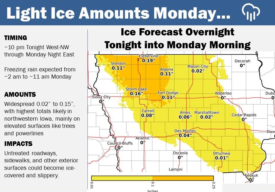
The icy conditions are expected to impact mainly elevated surfaces such as tree limbs and powerlines. However, any untreated roads, sidewalks, and other outdoor surfaces will become ice-covered and slippery. There is a potential to cause some tricky travel during the Monday morning commute, especially over northwest Iowa. If you live in the potentially impacted area, be prepared for increased travel times Monday morning and travel with extra caution.
Iowa Governor Kim Reynolds, Iowa Homeland Security and Emergency Management, and the National Weather Service have designated March 26th through March 30th as Severe Weather Awareness Week. Knowing when severe weather is possible will give you time to prepare! (Learn more at https://www.weather.gov/dmx/)
Each day during Severe Weather Awareness Week, the National Weather Service in Des Moines will cover severe weather topics:
Monday: Severe Thunderstorms
Tuesday: Receiving Warning Information
Wednesday: Tornadoes
Thursday: Family Preparedness
Friday: Flooding
If no severe weather is occurring or expected, the National Weather Service will
conduct a Tornado Drill on Wednesday, March 28th, between 10 and 11 a.m. The purpose of this drill is to ensure that Iowans can adequately receive a Tornado
Warning and can practice any actions that would be taken in the event of a real
tornado. The timeline for the drill is as follows:
Test Tornado Drill: Wednesday, March 28th at 10 AM (Primary Backup Date Thursday, March 29th at 10 AM, Secondary Backup Date Friday, March 30th at 10 AM)
Around 10:00 AM – A Test Tornado Watch will be issued for Iowa
Around 10:15 AM – A Test Tornado Warning will be issued for Iowa
10:35 AM – Test Tornado Warning for Iowa expires
11:00 AM – Test tornado watch expires
Today: Cloudy. High near 42. East southeast wind 10-20 mph.
Tonight: Mostly Cloudy w/a 40% chance of rain, with thunderstorms also possible after 4-a.m. Monday. Low around 35. East wind 10 to 15 mph. New rainfall amounts of less than a tenth of an inch, except higher amounts possible in thunderstorms.
Monday: Showers & possibly a thunderstorm. High near 47. E/SE wind 15-25 mph. New rainfall amounts between a quarter and half of an inch possible.
Monday Night: Showers & possibly a thunderstorm. Low around 35. East winds @ 5-10 becoming N/NW after midnight. New precipitation amounts between a tenth and quarter of an inch, except higher amounts possible in thunderstorms.
Tuesday: Mostly cloudy, with a high near 48. North northwest wind 10-20 mph.
Tuesday Night: Partly cloudy, with a low around 30.
Wednesday: Sunny, with a high near 60.
Wed. Night: A slight rain after midnight, possibly becoming mixed w/snow. Low 31.
Thursday: Partly sunny, with a high near 48.
Saturday’s High in Atlantic was 35. We received .01″ of precipitation during the day, in a combination of light rain/drizzle and a brief snow shower. Our Low this morning (as of 6-a.m.,) was 31. Last year on this date, the High in Atlantic was 43 and the Low was 39. The All-Time Record High in Atlantic on March 25th, was 91 in 1907, and the Record Low was 5, in 1894.
The National Weather Service in Des Moines says a strong weather system is moving east over the state early today. Rain will mix and change to snow central with heavy snow and near-blizzard conditions across the north. The storm will slow down this morning and produce snowfall amounts of 1 or more inches per hour across the north and northeast and farther south later this morning. Travel is discouraged today – especially over much of northern, eastern, northeastern and northwest Iowa. Southern Minnesota is also getting heavy snow today. Stay safe – Stay home. For the latest road conditions go to 511ia.org, or call 511.
Today: A rain-snow mix this morning before changing to all rain. High near 35. NE @ 15-25. New snow accumulation of less than a half inch possible.
Tonight: Mostly cloudy. Low around 29. E/NE wind @ 10-20mph.
Sunday: Mostly cloudy, with a high near 43. E/SE wind 10-20mph.
Sunday Night: A 40% chance of showers & thunderstorms. Low around 35.
Monday: An 80% chance of showers & thunderstorms. High near 50.New rainfall amounts between a quarter and half of an inch possible.
Monday Night: A 70% chance of shwrs & tstrms. Low around 38.
Tuesday: A 20% chance of rain before 1pm. Mostly cloudy, with a high near 47.
Friday’s High in Atlantic was 49. Our Low this morning (as of 5:30-a.m.) was 33. We received .45” of rain through 5:30-a.m., today, at the KJAN Studios. Last year on this date our High was 56 and the Low was 40. The record High in Atlantic on this date was 83 in 1967. The Record Low was -2, in 1974.
Cass County Emergency Management Director Mike Kennon reports the Cities of Atlantic, Lewis and Griswold will be testing their Outdoor Warning sirens each Friday at Noon, beginning today (Friday, 3/23). Anyone who notices a defective or improperly operating siren, should contact the Cass County Emergency Management Agency at 712-254-1500.
DES MOINES, Iowa (AP) — Forecasters say a major winter storm is expected to power through northeast and eastern Iowa. The National Weather Service’s winter storm warning issued Friday morning calls for snow and sleet accumulations of up to 10 inches or more (25-plus centimeters) through Saturday afternoon as the system moves east. The service says winds running from 15 to 25 mph will reduce visibility, imperiling people on the roadways.
Today: Mostly cloudy w/light rain. High near 50. SE @ 10-20.
Tonight: Cloudy, w/rain. Low 36. E @ 10-20.
Tomorrow: Cldy w/rain in the morning & a chance of flurries. High late around 41. E/NE @ 15-25.
Sunday: P/Cloudy. High 50.
Monday: Cloudy w/a chance of rain. High 54.
Thursday’s High in Atlantic was 58. Our Low this morning was 36. Last year on this date our High was 74 and the Low was 44. The record High in Atlantic on this date was 86 in 1910. The Record Low was 4, in 1974.
Jason Wickizer, Operations Officer for the Shelby County Emergency Management Agency, reports the Fire Danger index in Shelby County, will remain in the MODERATE Category through the weekend. He’s asking anyone planning to conduct an outdoor burn, to please call 712-755-2124, AND your local fire chief.
Today: Mostly cloudy w/scattered light rain this morning. High 52. SE @ 10-15.
Tonight: Mo. Cldy. Low 36.
Tomorrow: Mo. Cldy w/rain. High around 50. SE @ 15-25.
Saturday: Cloudy w/rain in the morning. High 44.
Sunday: P/Cldy to Cloudy. High near 50.
Wednesday’s High in Atlantic was 52. Our Low this morning was 32. We received a Trace of rain overnight here at the KJAN studios. Last year on this date our High was 50 and the Low was 30. The record High in Atlantic on this date was 86 in 1910. The Record Low was -6, in 1912.


