
Today: Areas of dense fog this morning; Partly cloudy to cloudy w/showers & thunderstorms, especially late this afternoon and this evening, when some of the storms may be severe. E/NE winds becoming SE @ 10-20. High near 70. New rainfall amounts between a quarter and half of an inch possible.
Tonight: Showers and thunderstorms likely, mainly before 7pm. Mostly cloudy, with a low around 50. N/NW @ 10-15. New rainfall amounts of less than a tenth of an inch, except higher amounts possible in thunderstorms.
Tomorrow: P/Cldy. High near 73. NW 10-20mph.
Saturday: P/Cldy. High near 78.
Sunday: A chance of showers in the morning, otherwise mostly sunny, with a high near 74.
Yesterday’s High in Atlantic was 66. Our Low this morning, 55. We received 1.26” of rain Wednesday evening into overnight Thursday at the KJAN Studios. Last year on this date our High was 65 and the Low was 37. The record High in Atlantic on this date was 87 in 1895,1949 & 1968. The Record Low was 25, in 1900.
DUBUQUE, Iowa (AP) — Forecasters say snowmelt and heavy rains are expected to send the Mississippi River above flood stage along most of Iowa. Warnings for minor flooding have been issued for several spots.
The National Weather Service says the river is expected to top flood stage later Wednesday at Dubuque and crest nearly 18 inches above flood stage by Friday evening. That would send water over the East Dubuque, Illinois, flats levee. Crests are expected downstream next week.
Shelby County Emergency Management Agency Operations Officer Jason Wickizer said today (Wednesday), at around 7:30-p.m. Tuesday, the Shelby County EMA received a report from the Walnut Fire Dept., of damage to buildings from severe weather that produced high winds, which were verified by Shelby County Sheriff Neil Gross, who was patrolling in Elk Horn at the time. Wickizer and Emergency Management Coordinator Bob Seivert responded to the area and verified no one was injured or displaced. Contact was made with the National Weather Service, and a preliminary damage report was made.
Emergency Management employees will make a damage assessment this morning. Wickizer advises area residents to “Please make sure you have a storm plan, and notification system like “Alert Iowa.” If you need assistance registering for this free storm notification system, call 712-755-2124, and an on-duty dispatcher will help you register, so you can receive a call on your home, office or cellular phone.
Severe storms that ripped through Nebraska Tuesday evening brought hail the size of baseballs, tornadoes and funnel clouds. When the storms entered Iowa, they caused damage to a machine shed and grain bin near Walnut, according to KETV. The National Weather Service says at around 4:30-p.m., marble-size hail was reported two-miles east/northeast of Yale, while penny-size hail was reported a few minutes later near Jamaica, in Guthrie County.
In northwest Iowa, the Pocahontas County community of Laurens saw golf ball-size hail fall at around 5:45-p.m., and half-dollar size hail fell twice, at around 5:30-and 5:54-p.m. A spotter near Charter Oak reported marble size hail at around 7:40-p.m., and 45-mile to 50-mile per hour winds blew near Bayard, in Guthrie County, at around 8:40-p.m., along with pea size hail. One-inch diameter (quarter-size) hail fell near Nevada (IA) at around 5:45-p.m., and ping-pong ball size hail fell near Napier, in Story County, at around 5:30-p.m. The same size hail was also reported to have occurred near Boone. Golf ball size hail was reported north of Madrid, a little after 5-p.m., as well. Other sites saw heavy rain cause minor street flooding, and in some places, hail covered the ground, making it look more like snow.
Another round of severe weather is possible late this afternoon into this evening, with large hail and damaging wind gusts being the greatest risks, though a tornado cannot be ruled out completely. Thunderstorms are expected to develop by later in the afternoon to our southwest over Kansas and then move northeast into the state. A localized heavy rainfall threat may develop, especially in areas that see repeated rounds of thunderstorm activity.
Today: Partly cloudy to cloudy w/afternoon showers & thunderstorms. High 76. SE @ 10-15.
Tonight: Mostly cloudy w/scattered showers & thunderstorms. Low 60. Winds light & variable.
Tomorrow: Mo. Cldy w/scatt. shwrs & tstrms. High 76. SE @ 10-20.
Friday: P/Cldy. High 74.
Saturday: P/Cldy. High 76.
Tuesday’s High in Atlantic was 77. Our Low was 57. We received .35” rain overnight (as of 5-a.m. today) at the KJAN Studios. Last year on this date our High was 66 and the Low was 39. The record High in Atlantic on this date was 91 in 1968. The Record Low was 17, in 1908.
The month of April was cooler and drier than normal, here in Atlantic. Weather records compiled at the KJAN studios (the official National Weather Service reporting site for Atlantic) show the average High temperature for the month was 55.7 degrees, which was 6.5 degrees cooler than normal. The average Low was 28.1, which was 9.3 degrees cooler than the norm.
Rainfall for the month was .6” (six-tenths of an inch), which was well below the normal of 3.43. Looking ahead to May, average precipitation amounts to 4.32 inches. The average High is731 degrees, while the average Low is 49.1 degrees.
The National Weather Service says strong to severe thunderstorms are expected to develop across much of western and central Iowa late this afternoon into this evening. The main threats will be large hail and damaging winds, although an isolated tornado or two remain possible. Localized heavy rain will also be possible into the overnight hours as the thunderstorms persists. Stay tuned for weather watches and warning, and be prepared to seek shelter when severe storms approach. KJAN will keep you informed on-air and on our social media apps. 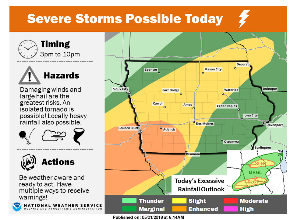
Today: Scattered showers & thunderstorms this morning & later this afternoon, otherwise partly cloudy. High near 80. S @ 15-25. Some storms later today may be severe, with the potential for large hail & damaging winds. An isolated tornado or two is also possible. Timing for severe weather: 3-until 10-p.m.
Tonight: Scattered showers & thunderstorms. Low 62. S @ 10.
Tomorrow: P/Cldy to Cldy w/scattered shwrs & tstrms. High 76. S @ 10-20.
Thursday: Mo. cldy w/scattered shwrs & tstrms. High 70.
Friday: P/Cldy. High 73.
Monday’s High in Atlantic was 83. Our Low was 59. We received .04” rain overnight at the KJAN Studios (through 5-a.m.) Last year on this date our High was 48 and the Low was 35. The record High in Atlantic on this date was 90 in 1965. The Record Low was 24, in 1909.
Shelby County Emergency Management Coordinator Bob Seivert reports the current weather conditions, and lack of rainfall have produced EXTREME Fire Danger conditions and will make any fires that do start, highly likely to spread very, very quickly. NO OPEN BURNING of any kind is recommended. Burn plans are required to be on file with Emergency Management, and, permission (signed burn plan) from the local Fire Chief are required during this time.
 Relative humidity values are low and high winds in excess of 30 mph are forecast for today (Monday). Frontal Boundaries will provide an opportunity for winds shifts, making any fires, difficult to control and predict. If you have recently burned an area, please keep an eye on it for rekindle. Do not hesitate to call 911 and report any fires today. Seivert says in addition, please be aware of the risk of severe weather over the next few days. It is probable that spotters will be deployed at some point.
The next Fire Danger Conditions update will be on Thursday, May 3rd.


