
Severe Thunderstorm Warning
National Weather Service Omaha/Valley Nebraska
356 PM CDT MON JUN 18 2018

The National Weather Service in Omaha has issued a

* Severe Thunderstorm Warning for...
  Northwestern Pottawattamie County in southwestern Iowa...
  Southeastern Harrison County in southwestern Iowa...
  Southwestern Shelby County in southwestern Iowa...

* Until 430 PM CDT.

* At 356 PM CDT, severe thunderstorms were located along a line
  extending from near Logan to 9 miles southeast of Missouri Valley
  to 5 miles west of Underwood, moving east at 25 mph.

  HAZARD...60 mph wind gusts.

  SOURCE...Radar indicated.

  IMPACT...Expect damage to roofs, siding, and trees.

* Locations impacted include...
  Logan, Underwood, Minden, Persia, Neola, Portsmouth, Arrowhead Park
  and Historical Village Welcome Center.

This includes Interstate 80 in Iowa between mile markers 17 and 31.

PRECAUTIONARY/PREPAREDNESS ACTIONS...

For your protection move to an interior room on the lowest floor of a
building.
Pottawattamie IA-Harrison IA-Washington NE-Douglas NE-
333 PM CDT MON JUN 18 2018

...A SEVERE THUNDERSTORM WARNING REMAINS IN EFFECT UNTIL 400 PM CDT
FOR NORTHWESTERN POTTAWATTAMIE...SOUTHWESTERN HARRISON...SOUTHEASTERN
WASHINGTON AND NORTHEASTERN DOUGLAS COUNTIES...

At 333 PM CDT, severe thunderstorms were located along a line
extending from 3 miles northwest of Missouri Valley to 8 miles east
of Fort Calhoun to Omaha, moving northeast at 40 mph.

HAZARD...70 mph wind gusts.

SOURCE...Radar indicated.

IMPACT...Expect considerable tree damage. Damage is likely to mobile
         homes, roofs, and outbuildings.

Locations impacted include...
Northeastern Omaha, Missouri Valley, Logan, Underwood, Fort Calhoun,
Crescent, Desoto Bend National Wildlife Refuge, Hitchcock Nature
Center, Wilson Island State Park and Historical Village Welcome
Center.

This includes the following highways...
 Interstate 29 between mile markers 58 and 79.
 Interstate 80 in Iowa between mile markers 14 and 20.
Severe Thunderstorm Warning
National Weather Service Omaha/Valley Nebraska
323 PM CDT MON JUN 18 2018

The National Weather Service in Omaha has issued a

* Severe Thunderstorm Warning for...
  Northwestern Pottawattamie County in southwestern Iowa...
  Southwestern Harrison County in southwestern Iowa...
  Southeastern Washington County in east central Nebraska...
  Northeastern Douglas County in east central Nebraska...

* Until 400 PM CDT.

* At 322 PM CDT, severe thunderstorms were located along a line
  extending from 4 miles east of Blair to near Fort Calhoun to Omaha,
  moving northeast at 40 mph.

  HAZARD...60 mph wind gusts.

  SOURCE...Radar indicated.

  IMPACT...Expect damage to roofs, siding, and trees.

* Locations impacted include...
  Northeastern Omaha, Missouri Valley, Logan, Underwood, Fort
  Calhoun, Crescent, Desoto Bend National Wildlife Refuge, Hitchcock
  Nature Center, Wilson Island State Park and Historical Village
  Welcome Center.

This includes the following highways...
 Interstate 29 between mile markers 58 and 79.
 Interstate 80 in Iowa between mile markers 14 and 20.

PRECAUTIONARY/PREPAREDNESS ACTIONS...

For your protection move to an interior room on the lowest floor of a
building.
306 PM CDT MON JUN 18 2018

The National Weather Service in Omaha has issued a

* Severe Thunderstorm Warning for...
  West central Pottawattamie County in southwestern Iowa...
  Southwestern Harrison County in southwestern Iowa...
  Southeastern Washington County in east central Nebraska...
  Northeastern Douglas County in east central Nebraska...

* Until 330 PM CDT.

* At 305 PM CDT, a severe thunderstorm was located 5 miles south of
  Kennard, or 12 miles northwest of Omaha, moving northeast at 25
  mph.

  HAZARD...60 mph wind gusts.

  SOURCE...Radar indicated.

  IMPACT...Expect damage to roofs, siding, and trees.

* Locations impacted include...
  Northern Omaha, Blair, Fort Calhoun, Kennard, Bennington,
  Washington, Desoto Bend National Wildlife Refuge and Wilson Island
  State Park.

PRECAUTIONARY/PREPAREDNESS ACTIONS...

For your protection move to an interior room on the lowest floor of a
building.
305 PM CDT MON JUN 18 2018 SEVERE THUNDERSTORM WATCH 188 IS IN EFFECT UNTIL 1000 PM CDT FOR THE FOLLOWING COUNTIES IN THE KJAN LISTENING AREA: ADAIR AUDUBON CARROLL CASS CRAWFORD DALLAS GUTHRIE HARRISON MADISON MONONA POTTAWATTAMIE SAC AND SHELBY.
A SEVERE THUNDERSTORM WATCH means conditions are or will be favorable for the development of severe storms that are capable of producing dangerous hail and high winds.
Prepare to seek shelter in the interior room of a building if a Severe Thunderstorm Warning is issued.
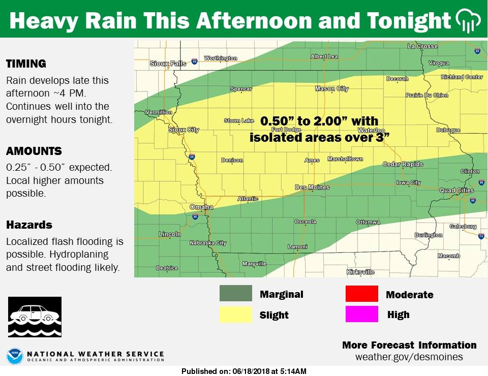
Thunderstorms are expected to develop late this afternoon over northern Iowa, generally between Interstate 80 to Highway 20. Heavy rain is likely with these storms where a widespread 0.50 to 2.00 inches are anticipated with a few localized areas possibly receiving over 3 inches by Tuesday morning. The rainfall rates of 1 to 3 inches per hour are possible at times and the rain may last for a long period over the same location. This could lead to areas of flash flooding by tonight into Tuesday morning. More thunderstorms with heavy rain are anticipated over portions of central to southern Iowa Tuesday into Wednesday and again Wednesday night into Thursday. Finally, a dry period is anticipated by late Friday across the state. 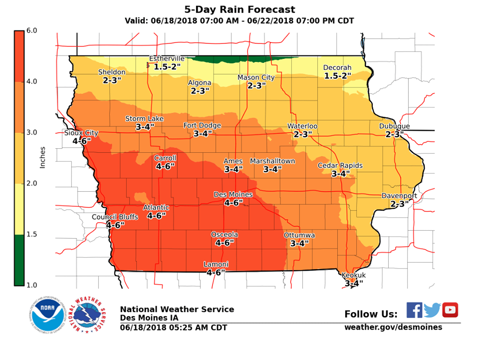
The National Weather Service says this this the last day (for a while) of the HEAT and HUMIDITY today across central and southern Iowa. High temperatures rise back into the 90s with heat index values over 100 degrees this afternoon can be expected. A HEAT ADVISORY is in effect until 7-p.m. for Cass-Adair-Adams-Audubon-Guthrie-Dallas-Madison-Union-Taylor and Ringgold Counties. A cold front sneaks into northern Iowa this afternoon, providing the focus for thunderstorms to develop. A few strong thunderstorms are possible in this location today, with the main threat of large hail and damaging winds. Heavy rain is also likely with the storms late this afternoon into the evening leading to the flash flood potential. An active weather pattern is forecast throughout the work week. Stay tuned for further updates.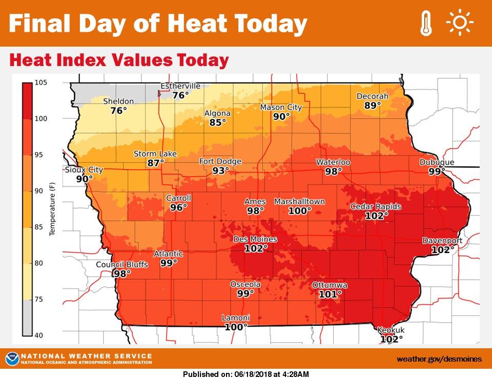
**HEAT ADVISORY until 7-p.m. for Cass, Adair, Adams, Audubon, Guthrie, Dallas, Madison, Union, Taylor and Ringgold Counties in the KJAN listening area**
Today: A 40 percent chance of showers and thunderstorms, mainly after 3pm. Mostly sunny, with a high near 91. South southwest wind 8 to 11 mph. New rainfall amounts between a tenth and quarter of an inch, except higher amounts possible in thunderstorms.
Tonight: Showers and thunderstorms likely, mainly before 2am. Mostly cloudy, with a low around 71. South southwest wind 6 to 8 mph becoming southeast in the evening. Chance of precipitation is 70%. New rainfall amounts between three quarters and one inch possible.
Tuesday: A 40 percent chance of showers and thunderstorms. Mostly cloudy, with a high near 84. South wind 7 to 9 mph. New rainfall amounts between a quarter and half of an inch possible.
Tuesday Night: Showers and thunderstorms likely, mainly after 1am. Mostly cloudy, with a low around 67. Southwest wind 5 to 7 mph becoming light and variable. Chance of precipitation is 60%. New rainfall amounts between a quarter and half of an inch possible.
Wednesday: Showers and thunderstorms, mainly after 1pm. High near 78. Chance of precipitation is 80%. New rainfall amounts between a half and three quarters of an inch possible.
Wednesday Night: Showers and thunderstorms. Low around 65. Chance of precipitation is 80%.
Thursday: Showers and thunderstorms likely. Cloudy, with a high near 76. Chance of precipitation is 60%.
Yesterday’s High in Atlantic was 92. Our Low this morning (as of 5:15-a.m.) was 76. Last year on this date our High was 78 and the Low was 55. The record High in Atlantic on this date was 98 in 1910. The Record Low was 46, in 1974 & 2000.
646 PM CDT Sun Jun 17 2018

...Persistent And Oppressive Heat Will Continue into Monday over
portions of Central and Southern Iowa...

.The combination of hot temperatures and humidity will produce
dangerous heat conditions into Monday for portions of central and
southern Iowa. Improvement is expected by Monday over northern
Iowa as a boundary enters the area and chances for thunderstorms
increase. Cooler conditions will arrive for the remainder of the
area by Tuesday.

Audubon-Guthrie-Dallas-Polk-Jasper-Poweshiek-Cass-Adair-Madison-
Warren-Marion-Mahaska-Adams-Union-Clarke-Lucas-Monroe-Wapello-
Taylor-Ringgold-Decatur-Wayne-Appanoose-Davis Counties...

...HEAT ADVISORY REMAINS IN EFFECT UNTIL 7 PM CDT MONDAY...

* TEMPERATURE...One more day of hot and humid conditions are
  expected. Highs temperatures on Monday will again be in the
  low to mid 90s with dewpoints in the lower 70s. This
  combination will result in heat index values of 100 to 105
  degrees.

* IMPACTS...Lack of overnight relief from the heat will lead to
  additional stress. Gusty winds today will increase the risk of
  dehydration. The wind gusts will not be as strong on
  Monday.The prolonged nature of this event will compound and
  amplify heat- related impacts.

PRECAUTIONARY/PREPAREDNESS ACTIONS...

A Heat Advisory means that a period of hot temperatures is
expected. The combination of hot temperatures and high humidity
will combine to create a situation in which heat illnesses are
possible. Drink plenty of fluids, stay in an air-conditioned
room, stay out of the sun, and check up on relatives and
neighbors. Never leave infants, children or pets in a parked car,
even for a minute.
Severe Thunderstorm Warning
National Weather Service Omaha/Valley Nebraska
429 PM CDT SUN JUN 17 2018

The National Weather Service in Omaha has issued a

* Severe Thunderstorm Warning for...
  Southeastern Monona County in west central Iowa...
  Northeastern Harrison County in southwestern Iowa...
  Northwestern Shelby County in southwestern Iowa...

* Until 500 PM CDT.

* At 429 PM CDT, severe thunderstorms were located along a line
  extending from Pisgah to 8 miles south of Dunlap to 4 miles
  northeast of Persia, moving northeast at 40 mph.

  HAZARD...60 mph wind gusts.

  SOURCE...Radar indicated.

  IMPACT...Expect damage to roofs, siding, and trees.

* Locations impacted include...
  Earling, Defiance, Woodbine, Dunlap, Panama, Portsmouth,
  Westphalia, Manteno Recreation Area, Schaben Park and Willow Lake
  Recreation Area.

PRECAUTIONARY/PREPAREDNESS ACTIONS...

For your protection move to an interior room on the lowest floor of a
building.


