
The National Weather Service says Mother Nature could provide her own version of fireworks today. Thunderstorms are expected to develop across much of northern Iowa, and become more widespread into the late afternoon and evening hours. Some severe storms will be possible, with damaging wind and large hail the main severe threats. Heavy rainfall is possible with the storms, which may lead to localized flash flooding.The timing for development of storms is anywhere from 2-p.m. until Midnight. Keep it tuned to KJAN, our website or mobile apps, for any weather watches or warnings that may be issued.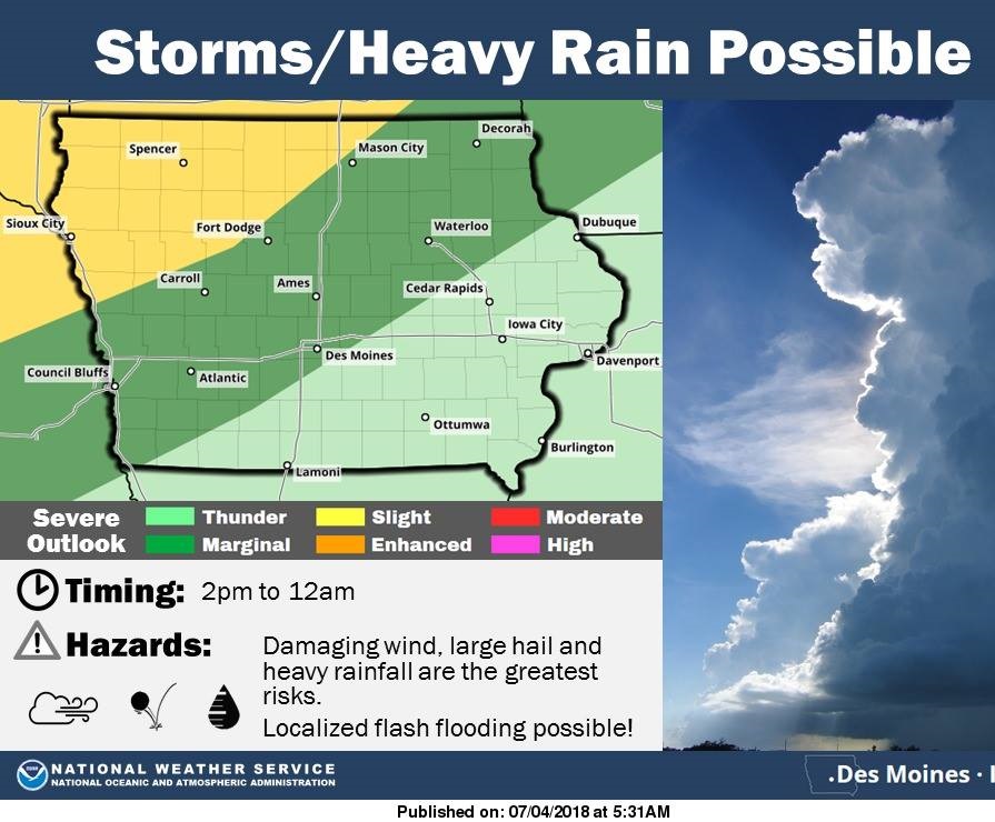
An El Nino Watch is being issued by the Climate Prediction Center, as conditions become favorable for the development of another round of Pacific Ocean warming. Meteorologist Dennis Todey, director of the U-S-D-A’s Midwest Climate Hub, based in Ames, says we’ll likely feel the impact in a few months. “We could see an El Nino occur probably into the fall, is what I would guess we’re looking at,” Todey says. “There is a fairly decent pool of warm water in the subsurface in the equatorial Pacific. When you start seeing that and the computer models all line up I’d say, yeah, we’re probably headed that way.”
Farmers across Iowa will need to take particular note as the weather pattern often shifts the region’s climate. Todey says the impacts of the developing El Nino will be felt late this year into next. “We have an increased chance of being warmer during the wintertime with El Nino,” he says. “The storm track moves up a little bit further north, you may have more mixed-precipitation-types of storms with the warmer temperatures than overall snowfalls.” Todey says they are also watching the current warming trend across the Northern Plains. “Even if you’ve got decent soil moisture, warmer temperatures start to extract more water from the soil because of higher atmospheric demand,” Todey says. “We’re getting to that time of year where corn is starting to use more water anyway. That’s a more immediate concern and then it becomes how much more precipitation are we really going to get, and that’s been a tough call so far this year.”
Todey says a La Nina — or cooling of the ocean — ended last year and we’ve been in a neutral phase since then.
(Radio Iowa)
Today: **HEAT ADVISORY from Noon until 8-p.m.** Partly cloudy, warm & humid w/isolated afternoon showers possible. High 93. Heat Index 105. S @ 10-20 mph.
Tonight: Becoming mostly Cloudy w/a 30% chance showers & thunderstorms, mainly after midnight. Low 70. S @ 5-10.
Tomorrow: Mo. Cldy w/scattered showers possible early. High 84. N @ 10.
Friday: P/Cldy. High 84.
Saturday: P/Cldy. High 86.
Tuesday’s High in Atlantic was 91. Our Low 68. Last year on this date, the High in Atlantic was 89 and the Low was 62. The All-time Record High for this date in Atlantic was 111 in 1936. The Record Low was 41 in 1967.
Area Counties: Sac-Crawford-Carroll-Audubon-Guthrie-Dallas-Cass-Adair-Madison-Adams-Union-Taylor-Ringgold
239 PM CDT Tue Jul 3 2018
…HEAT ADVISORY IN EFFECT FROM NOON TO 8 PM CDT WEDNESDAY…
* TEMPERATURE… Temperatures in the lower 90s coupled with dewpoints in the mid 70s will result in heat indices between 100 and 105 degrees.
* IMPACTS…Heat illnesses are possible for those active outdoors this afternoon. Vulnerable populations such as children and the elderly as especially susceptible. Those planning outdoor holiday activities need to take necessary precautions to beat
the heat.
PRECAUTIONARY/PREPAREDNESS ACTIONS…
A Heat Advisory means that a period of hot temperatures is expected. The combination of hot temperatures and high humidity will combine to create a situation in which heat illnesses are possible. Drink plenty of fluids, stay in an air-conditioned
room, stay out of the sun, and check up on relatives and neighbors.
Today: Partly cloudy. High 91. S @ 10-15 mph
Tonight: P/Cldy. Low 73. S @ 5-10.
Tomorrow: P/Cldy, warm & humid w/isolated showers possible late. High 95. S @ 10-15.
Thursday: Mostly cloudy w/shwrs & tstrms possible. High 84.
Friday: P/Cldy. High 84.
Yesterday’s High in Atlantic was 84. Our Low this morning 61. Last year on this date our High was 90 and the Low was 64. The record High in Atlantic on this date was 107 in 1936. The Record Low was 43, in 1967 and 1968.
The totals collected by state climatologist Justin Glison confirm what appeared to be happening in June in much of the state — it was wetter than normal. He says we got an average six-point-seven-six inches of precipitation compared to the normal five inches. June also averaged four degrees warmer than normal at 73 degrees.
Glison says those numbers for June are near the top of the weather records. “Preliminary we are running at the ninth warmest month and the 13th wettest month on record,” according to Glison. The numbers are averaged out from across the state, as Glison says precipitation varied greatly.”What we’re seeing is a weird distribution of rainfall. I mean, the north and west have received between 100 and 200 percent of what they normally would receive in June,”Glison says. “While you look at the south and the southeast in particular — which is in D-2 drought still — they are running between 50 and 75 percent of what they should have year to date.”
Glison says part of the problem is the gentle two-hour rains have gone away in the last several years and we now get more sporadic rain events. “We’ve really seen that trend hit this month. With the jet stream being so far north we get these days on end and weeks on end where we have warm moist air over the state. So when you sort of boundary that move, then that will just force thunderstorms to pop up. So, that’s the kind of unusual behavior that we’re seeing in June,” he says.
Glison took over as the state climatologist in June, following the retirement of Harry Hillaker.
(Radio Iowa) * June 2018 weather data for Atlantic can be found on the “Weather” page at kjan.com*
Today: Partly to Mostly Sunny. High 86. SE @ 10.
Tonight: Partly cloudy. Low 66. SE @ 5-10.
Tomorrow: P/Cldy. High near 90. S @ 10-15.
Wednesday (Independence Day): P/Cldy. High 92.
Thursday: P/Cldy to Cldy w/a chance of shwrs & tstrms. High 88.
Yesterday’s High in Atlantic was 82. We received a trace of precipitation after 7-a.m., in the form of drizzle/mist. Our Low this morning 58. Last year on this date our High was 83 and the Low was 62. The record High in Atlantic on this date was 102 in 1911. The Record Low was 45, in 1924 and 1959.
The month of June was extremely soggy here in Atlantic, in fact, nearly 5.6-inches shy of the record for rainfall. We received 12.32-inches at the KJAN Studios in June. (The record was 17.91 in 1998)The greatest amounts of precipitation fell on the 1st, 10th, 18th, 19th, and 30th. Normal rainfall for the month is 4.98-inches.
The average High was 84-degrees, which was slightly greater than the norm of 83. The hottest days were on the 1st, 6th, 15th through the 19th and on the 29th, when the temperature was 91 degrees or greater. The average Low was 64-degrees, which was a little more than 5-degrees above normal. The coolest morning was June 3rd when we bottomed out at 48.
Looking ahead to July, the average High is 86, and the average Low is 63. Normal precipitation for the month amounts to 4.62-inches.
Atlantic (KJAN), 2.30 inches
Massena, 1.07″
Missouri Valley, .68″
Ankeny, 8.72″
Dallas Center, 5.00″
Des Moines, 5.44″
Waukee, 3.71″
Today: A 40% chance of showers and thunderstorms, mainly before 9am; Gradually becoming mostly sunny, with a high near 82. Southwest wind 10 to 15 mph becoming northwesterly this afternoon.
Tonight: Mostly clear, with a low around 62. Northwest wind 5 to 10 mph becoming calm in overnight.
Monday: Sunny, with a high near 85. Light south wind becoming south southeast 5 to 10 mph in the morning.
Monday Night: Partly cloudy, with a low around 68. Southeast wind around 10 mph.
Tuesday: Mostly sunny, with a high near 89.
Independence Day: Mostly sunny, with a high near 90.
Yesterday’s High in Atlantic was 89. Our Low was 69. We received 2.3-inches of rain at the KJAN Studios over the past 24-hours ending today at 7-a.m. Last year on this date our High was 82 and the Low was 59. The record High in Atlantic on this date was 104 in 1938. The Record Low was 45, in 1930, 1951 and 1995.


