
Today: Variably cloudy w/scattered showers & thunderstorms this morning; Partly cloudy this afternoon. High 83. Winds variable @ 5-10 mph.
Tonight: Partly cloudy. Low 60. N @ 5-10 mph.
Tomorrow: Mo. Sunny. High 85. N @ 10.
Thursday: P/Cldy. High 86.
Friday: P/Cldy. High 87.
Yesterday’s High in Atlantic was 88. Our Low was 67. We received .17” rain overnight here in Atlantic. Last year on this date our High was 80 and the Low was 49. The record High in Atlantic on this date was 103 in 1937. The Record Low was 45 in 1989.
Today: Variably cloudy with scattered showers & thunderstorms ending this morning but redeveloping this afternoon. High 83. E/NE @ 10 mph.
Tonight: Any showers ending this evening; Partly Cloudy. Low 63. N @ 5-10.
Tomorrow: P/Cldy. High 83. N @ 10. Mo.
Wednesday: Mostly sunny, with a high near 85.
Thursday: P/Cldy. High 85.
Yesterday’s High in Atlantic was 91. Our Low this morning: 67. Last year on this date our High was 77 and the Low was 56. The record High in Atlantic on this date was 105 in 1930. The Record Low was 46 in 1974 & 1997.
The National Weather Service in Des Moines reports there is a slight risk for severe weather this afternoon, mainly north of Interstate 80. Severe weather can be expected to start middle to late afternoon and continue through the evening. This morning’s system may limit new development to some extent, but the atmosphere will likely be able to recover. The main threats this afternoon are large hail, damaging wind, and excessive rainfall. 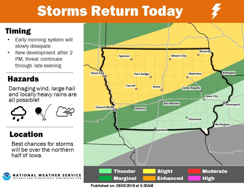
Today: Partly sunny, with a high near 93. South southwest wind 10-to 20-mph.
Tonight: Mostly cloudy with a 50% chance of showers and thunderstorms, mainly after 11pm. Low around 70. South wind 5-to 10-mph becoming east southeast after midnight. New rainfall amounts between a tenth and quarter of an inch, except higher amounts possible in thunderstorms.
Monday: Partly sunny w/a 30% chance of showers and thunderstorms. High near 85. SE winds in the morning becoming W/NW @ 5-10 in the afternoon. New rainfall amounts of less than a tenth of an inch, except higher amounts possible in thunderstorms.
Monday Night: Mo. Cldy w/a 30% chance of showers and thunderstorms, mainly before 1am. Low around 64. N/NE @ 5-10. New rainfall amounts of less than a tenth of an inch, except higher amounts possible in thunderstorms.
Tuesday: Mostly sunny, with a high near 82. N @ 5-10.
Wednesday: Sunny, with a high near 84.
(Radio Iowa) — It’s been cooler-than-normal for summertime in Iowa but today (Friday) and the next several days, the forecast is calling for hotter, steamier weather. Meteorologist Andrew Ansorge (AN-sore-ghee), at the National Weather Service, says cities from Shenandoah to Lamoni to Des Moines may see highs of 95-degrees this afternoon. “We’ll be flirting with mid-90s today in a few spots in Iowa but overall the next few days, we’re looking at high temperatures in the 80s to low 90s in general,” Ansorge says. “We’re also looking at dewpoints to increase into the 60s to near 70-degrees each day, so, it’ll feel a bit more humid than it has recently.”
These temperatures are relatively normal for early August, but it just seems hotter since we’ve had cooler weather for a while. “We had a cool spell there, relatively speaking, in the latter part of July, which was much needed,” Ansorge says. “We’ve not seen much rainfall in the state so the cooler temperatures helped to ease the stress on crops. It’s still dry, but it could’ve been worse if it had been scorching hot the latter part of July.”
Iowans who don’t use sprinklers or an irrigation system likely haven’t had to mow their lawns for a week or two and the grass is probably starting to get brown and crunchy. Relief may be coming soon. “We’re looking at storm chances returning this weekend, northern Iowa more-so on Saturday and on Sunday into Sunday night, we’re looking at more statewide having a chance of rainfall,” Ansorge says. “Looks like the heaviest rainfall will probably not be where the drought conditions are over southern Iowa, but there still looks to be some rainfall down there.”
Today: Mostly sunny. High 91. SW @ 10-20 mph.
Tonight: Partly cloudy. Low 70. S @ 5-10 mph.
Tomorrow: Variably cloudy w/scattered showers & thunderstorms. High 87. S @ 10-15.
Sunday: P/Cldy w/isolated thunderstorms. High 89.
Monday: Mostly cloudy w/scatt. shwrs & tstrms. High 85.
Yesterday’s High in Atlantic was 84. Our Low was 57. Last year on this date our High was 75 and the Low was 48. The record High in Atlantic on this date was 107 in 1930. The Record Low was 42 in 1907.
Today: Partly cloudy. High 81. E/NE @ 10.
Tonight: P/Cldy. Low 62.
Tomorrow: P/Cldy. High 91. SW @ 10-20.
Saturday: P/Cldy w/scattered showers & thunderstorms. High 87.
Sunday: P/Cldy w/isolated shwrs & tstrms. High 89.
Yesterday’s High in Atlantic was 85. Our Low was 53. Last year on this date our High was 86 and the Low was 64. The record High in Atlantic on this date was 103 in 1930. The Record Low was 42 in 1907.
The month of July was slightly cooler and much drier than normal. Weather data here at KJAN show the average High for the month was 85.6 degrees. The normal average is 85.8. The last day of June we received 2.3” of rain, but the spigot was left to drip in July.
Rainfall for the month was well below normal, at just .82”. Normally, we receive 4.62” of rain in July. The average Low of 61.1 was two-degrees cooler than the normal 63.1. Looking ahead to August, normal rainfall is 3.88 inches. The average High is 83.3, and the average Low is 60.6.
Today: Areas of fog this morning, otherwise partly cloudy, w/isolated showers & thunderstorms possible toward this evening. High 87. SW @ 10-15.
Tonight: P/Cldy w/isolated shwrs & tstrms early. Low 65.
Tomorrow: P/Cldy. High 84. NE @ 10.
Friday: P/Cldy. High 90.
Saturday: Variably cloudy w/scattered showers & tstrms. High 88.
Yesterday’s High in Atlantic was 85. Our Low this morning was 53. Last year on this date our High was 86 and the Low was 59. The record High in Atlantic on this date was 102 in 1897. The Record Low was 42 in 1898.
(Radio Iowa) — Aside from an outburst of destructive tornadoes two weeks ago, the just completed month of July was fairly uneventful in terms of weather. State Climatologist Justin Glisan says it was a welcome change from the extremes Iowans experienced the previous three months. “April was the coldest April on record, May was the warmest May on record, and then June was the 10th warmest and 10th wettest on record,” Glisan said. “Then, we get to July and compared to those months, it’s kind of ‘ho-hum,’ we’re almost in the middle for average temperature and almost in the middle for precipitation.”
It appears July 2018 will wind-up being the 55th coolest July in state history (tied with 1928 and 1981). 1936 was the warmest July of record, at 82.7 degrees…about 9 degrees above normal. 2009 was the coldest July on record at 68 degrees, almost six degrees below normal. The highest temperature recorded in Iowa last month was 101-degrees, in Lamoni, on July 13. The towns of Stanley, Sheldon, and Waukon tied for the coldest temperature of 48 on July 27th and 28th.
The statewide preliminary average temperature last month — 73.3 degrees — is only three-tenths-of-a-degree below normal for a typical July. “The beginning of the month was really hot, but we made up for it towards the end of the month with below average temperatures across much of the state,” Glisan said. The statewide preliminary average rainfall total for July is three-point-five inches. That’s just an inch below normal for a typical July.
“It has seemed dry, especially in the southern part of the state – where they’re in drought conditions. They’re in a deficit of rainfall, over the past three years in some places, up to 20 inches,” Glisan said. “Then, you have the northern part of the state that has been getting too much rain.”
The National Weather Service is still investigating, but so far, 12 tornadoes have been confirmed in Iowa last month. They all happened on the same day, with the three strongest twisters touching down in Marshalltown, Pella, and Bondurant. “On the 19th, we had three large population centers taking direct hits, which does not happen at all,” Glisan said.
Only minor injuries were reported in that tornado outbreak. Through the first seven months of 2018, there have been 27 tornadoes confirmed in Iowa.


