
Today: Areas of morning fog; P/Cldy. High 88. S @ 10.
Tonight: P/Cldy w/isolated thunderstorms late. Low 72. S @ 5-10.
Tomorrow: Isolated showers & thunderstorms early; P/Cldy, warm & humid. High 90. S @ 10-15.
Friday: Mo. Sunny. High 94.
Saturday: P/Cldy w/a chance of afternoon shwrs & tstrms. High 92.
The National Weather Service says a weak tornado (estimated at EF-0) lifted some debris into the air Monday evening, in Ringgold County. A trained spotter observed the rain-wrapped twister near Delphos at around 5:17-p.m.. A funnel cloud was also observed one-mile west/southwest of Redding, at around 4:55-p.m. The funnel lasted for about five-minutes. There were no reports of injuries. Heavy rain was the main feature of the storms that passed through western and central Iowa, Monday.
Rainfall in excess of three-inches was reported in Des Moines. Other communities saw anywhere from 2.1- to as much as 4-inches of rain in central Iowa. The heavy rain led to street flooding in Des Moines, Pleasant Hill and Cumming, Monday evening, as well.
Today: Mostly cloudy w/scattered showers & thunderstorms possible through mid-day. High 79. W @ 10-15.
Tonight: Partly cloudy. Low 64. Winds light & variable.
Tomorrow: Areas of morning fog; P/Cldy. High 86. S @ 10.
Thursday: P/Cldy w/scattered thunderstorms possible (early), High 92.
Friday: P/Cldy. High 94.
Yesterday’s High in Atlantic was 75. Our Low this morning was 64. We received .57” of rain yesterday into early this morning (thru 5:30-a.m.). Last year on this date our High was 76 and the Low was 44. The record High in Atlantic on this date was 103 in 1934 & 1936. The Record Low was 43, in 1902.
Today: Partly cloudy to cloudy w/scattered showers & thunderstorms. High 79. SE @ 10-20.
Tonight: Mostly cloudy w/scatt. shwrs & tstrms, w/periods of heavy rain. Low 64. SE @ 10-15.
Tomorrow: Mo. Cldy w/scatt. shwrs & tstrms, especially in the morning. High 79. W @ 10-15.
Wednesday: P/Cldy w/shwrs & tstrms late. High 86.
Thursday: P/Cldy w/shwrs early. High 92.
Yesterday’s High in Atlantic was 86. Our Low this morning was 64. We received .44” of rain yesterday. Last year on this date our High was 74 and the Low was 48. The record High in Atlantic on this date was 106 in 1937. The Record Low was 40, in 2004.
The National Weather Service in Des Moines reports strong to severe thunderstorms are possible during the afternoon through evening hours both today (Sunday) and tomorrow (Monday). For today, damaging winds will be the primary threat, with large hail the secondary threat. Most of these storms should diminish by 10 pm.
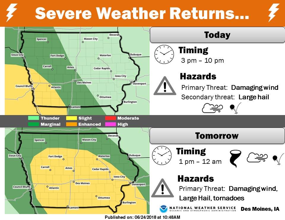 Locations under the greatest threat are west of Interstate 35. For tomorrow, a more widespread threat for severe weather exists. Lines of storms are expected to move from SW to NE through the afternoon and evening hours. At this time, it appears conditions will be favorable for a tornado or two to form, along with damaging winds and large hail.
Today: Partly sunny w/a 40% chance of showers and thunderstorms, mainly after 2pm. High near 84. S/SE wind 5 to 10 mph. New rainfall amounts between a tenth and quarter of an inch, except higher amounts possible in thunderstorms.
Tonight: Mostly cloudy w/a 60% chance of showers & thunderstorms, mainly after midnight. Low around 68. E/SE @ 5-10. New rainfall amounts between a quarter and half of an inch possible.
Monday: Cloudy w/a 70% chance of shwrs & tstrms. High near 78. S/SE @ 10-20 mph. New rainfall amounts between a half and three quarters of an inch possible.
Monday Night: A 40% chance of showers and thunderstorms. Low around 66.
Tuesday: P/Sunny w/a 30% chance of showers and thunderstorms, mainly during the morning. High near 84.
Wednesday: Sunny, with a high near 89.
Skyscan Forecast Saturday, June 23, 2018 Richard Garuckas
Today: Mostly cloudy. 30% chance of showers. High 79. S @ 5-10.
Tonight: Mostly cloudy. 30% chance of showers. Low 64. SSE @ 5-10.
Sunday: Partly sunny. Slight chance of showers and thunderstorms. High 83. SSE @ 5-10.
Sunday Night: Mostly cloudy. Showers and thunderstorms likely. Low 67.
Monday: Showers and thunderstorms likely in the morning, becoming partly cloudy. High 82.
Tuesday: Partly cloudy. Slight chance of showers and thunderstorms. High 87.
Wednesday. Mostly sunny. High 91.

Podcast: Play in new window | Download (541.7KB)
Subscribe: RSS
Today: Partly cloudy to cloudy w/isolated showers possible. High 74. N @ 10-15mph.
Tonight: P/Cldy. Low 58. N @ 5.
Tomorrow: P/Cldy w/showers possible late in the day. HIgh 80. SE @ 10.
Sunday: Variably cloudy w/scatt. shwrs & tstrms. High 82.
Monday: Mo. cldy w/showers & tstrms. High near 80.
Yesterday’s High in Atlantic was 78. Our Low this morning was 59. We received .06” of rain yesterday. Last year on this date our High was 86 and the Low was 57. The record High in Atlantic on this date was 100 in 1933. The Record Low was 39, in 1972.


