
8:21-p.m. Tstrm wind gust est. 65-70 mph estimated by radar, 4 miles N. of New Market in Taylor County; Law enforcement report
8:30-p.m. Estimated 70 mph wind 9 miles sw of Bedford in Taylor Co.; Trained spotter report.
8:01-to 8:15-p.m. 62-68 mph gusts of wind reported in Clarinda.
7:38-p.m. Thunderstorm winds est. at 58 mph 1 mile w/nw of Red Oak.
7:28-p.m. Shingles blown off homes in Coburg (Montgomery County). 1′ diameter tree limbs reported down.
7:15-p.m. Three farm storage buildings destroyed 3 miles s. of Thurman, in Fremont County
7:00-p.m. A total of 9 semi tractor-trailers were overturned along I-29 about 3 miles west of Thurman, in Fremont County (Storm Chaser report). Two drivers were injured and transported by ambulance. I-29 was closed in both directions; Numerous power lines were down west of Thurman and many large trees were uprooted in Thurman, where there was damage to roofs as well.
WATERLOO, Iowa (AP) — Authorities say minor to moderate flooding along the Cedar River in northeast Iowa could worsen if scattered thunderstorms in the forecast bring heavy rainfall. The National Weather Service said Monday that the Cedar River at Cedar Falls already was more than 3 feet (1 meter) above flood stage and wasn’t expected back below until Thursday morning. The flooding forced closure of George Wyth Memorial State Park in northwest Waterloo, and street flooding has been reported.
The Shell Rock River is causing minor flooding in Shell Rock and isn’t expected back below flood stage until Tuesday morning — a forecast that could change with any appreciable rain. The city of Greene has erected barriers keep out floodwaters. A flood warning also has been issued for the Winnebago River in Mason City.
Severe storms are possible by late this afternoon and tonight as a cold front passes across the state. The National Weather Service says there is a “slight” risk for large hail and damaging winds with these storms, though an isolated tornado may occur. In addition, locally heavy rainfall may occur. The storms are expected to develop between 4-p.m. and Midnight. Listen for further updates on the weather situation on KJAN, watch for them our mobile apps and be prepared to take shelter should severe weather strike. 
Today: Showers and thunderstorms likely before 7am, then isolated showers and thunderstorms after 5pm. Partly sunny, with a high near 86. Southeast wind 11 to 14 mph, with gusts as high as 21 mph. Chance of precipitation is 60%. New rainfall amounts between a quarter and half of an inch possible.
Tonight: Showers and thunderstorms likely, mainly before 11pm. Cloudy, then gradually becoming partly cloudy, with a low around 63. Southeast wind 7 to 9 mph becoming north northwest after midnight. Chance of precipitation is 60%. New rainfall amounts between a tenth and quarter of an inch, except higher amounts possible in thunderstorms.
Tuesday: Mostly sunny, with a high near 83. North wind 7 to 9 mph.
Tuesday Night: Mostly clear, with a low around 60. North northeast wind 3 to 6 mph.
Wednesday: Mostly sunny, with a high near 85.
Wednesday Night: A 50 percent chance of showers and thunderstorms, mainly after 1am. Mostly cloudy, with a low around 66.
Thursday: A 20 percent chance of showers and thunderstorms before 1pm. Mostly sunny, with a high near 91.
Yesterday’s High in Atlantic was 81. Our Low this morning was 65. Rainfall over the past 24-hours amounted to 2.61 inches (1.28 fell during the day yesterday). Last year on this date our High was 95 and the Low was 74. The record High in Atlantic on this date was 99 in 1892. The Record Low was 36, in 1903.
The National Weather Service reports isolated severe storms are possible today (Sunday), mainly over central Iowa. Severe storms are possible again on Monday, especially by late afternoon and into the evening. Large hail and damaging winds will be the main threats though isolated tornadoes may occur. In addition locally heavy rainfall is possible. 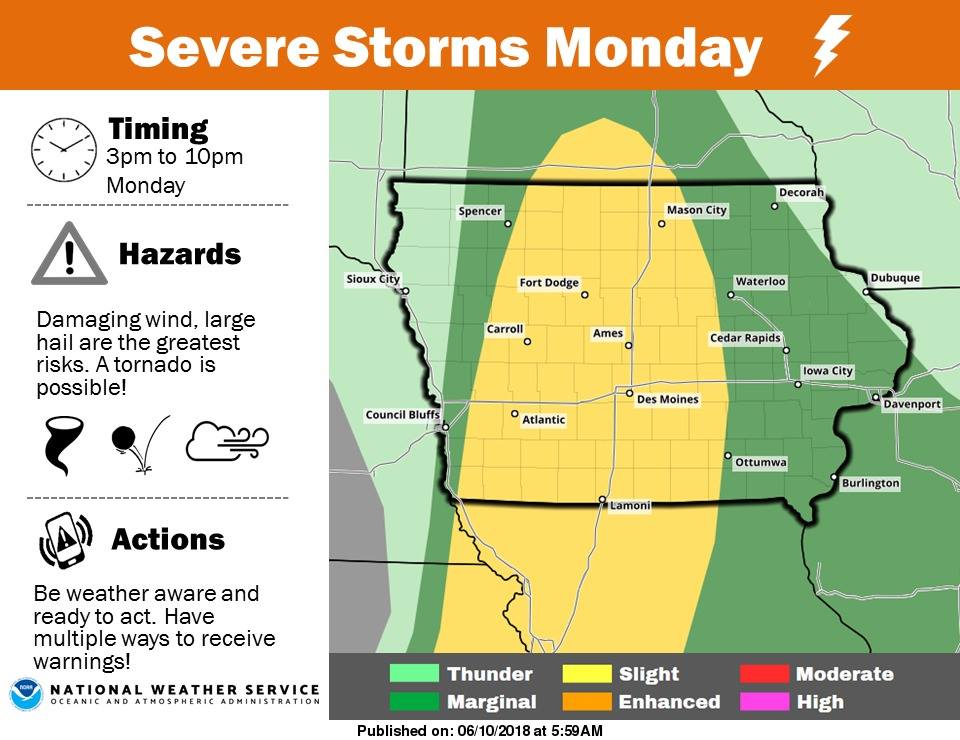
Today: Partly sunny w/a 40% chance of showers & thunderstorms, mainly before 2pm. High near 91. East northeast wind 5 to 10 mph becoming south southeast this afternoon. New rainfall amounts of less than a tenth of an inch, except higher amounts possible in thunderstorms.
Tonight: Partly cloudy, with a low around 69. East southeast wind around 10 mph.
Monday: Mostly sunny w/a 40% chance of showers & thunderstorms after 1pm. High near 90. South southeast wind 10 to 15 mph, with gusts around 20. New rainfall amounts of less than a tenth of an inch, except higher amounts possible in thunderstorms.
Monday Night: Mo. Cldy w/a 30% chance of showers & thunderstorms through midnight. Low around 60. North wind 10-20. New rainfall amounts of less than a tenth of an inch, except higher amounts possible in thunderstorms.
Tuesday: Sunny, with a high near 83. North wind 7 to 9 mph.
Wednesday: Mostly sunny, with a high near 84.
Yesterday’s High in Atlantic was 89. Our Low this morning was 67. We received .04” rain from 6-a.m. To 7-a.m. Today. Last year on this date our High was 92 and the Low was 70. The record High in Atlantic on this date was 104 in 1933. The Record Low was 40, in 1966.
Skyscan Forecast Saturday, June 9, 2018 Richard Garuckas
Today: Showers and Thunderstorm early. Becoming partly cloudy. Hot and humid. High 90. S @ 10-15, gusting to 20.
Tonight: Mostly cloudy. Moderate chance of showers and thunderstorms. Muggy. Low 71. SSE @ 10-15.
Sunday: Partly cloudy. Slight chance of a morning shower. Hot and humid. High 91. SSE @ 10-15, gusting to 20.
Sunday Night: Partly cloudy. Muggy. Low 72.
Monday: Partly sunny. Moderate chance of afternoon shower and thunderstorms. Hot and humid. High 90.
Tuesday: Mostly sunny. Cooler and less humid. High 83.
Wednesday: Mostly sunny. High 85.

Podcast: Play in new window | Download (481.9KB)
Subscribe: RSS
Today: Partly cloudy w/isolated afternoon showers & thunderstorms. High 90. SE @ 10-20.
Tonight: P/Cldy w/scattered shwrs & tstrms. Low 70. SE @ 5-10.
Tomorrow: Scatt. shwrs & tstrms early; P/Cldy. High 88. SE @ 10-15.
Sunday: Shwrs & tstrms early; P/Cldy. High 92.
Monday: P/Cldy w/tstrms late. High 91.
Yesterday’s High in Atlantic was 83. Our Low this morning (as of 5-a.m.) was 65. Last year on this date our High was 87 and the Low was 59. The record High in Atlantic on this date was 102 in 1985. The Record Low was 38, in 1930.
A film crew from National Geographic has been in Iowa this week, capturing material for a documentary about devastating floods that hit parts of the state in 2008 and 2016. Clarksville Mayor Val Swinton says the seven-person crew spent time in his town, located in Butler County. “It’s a documentary about the changes in the weather and so they wanted to know about the floods and how these two floods, that were so big and happened so close together, represented a change in our weather pattern,” Swinton said.
In September 2016, nearly 300 Clarksville residents were forced out their homes when torrential rains pushed the Shell Rock River over a temporary levee. This month marks the 10-year anniversary of the 2008 flood that buried much of Eastern Iowa under water – including Clarksville.
“We just had a 500-year flood in 2016 and one in 2008, which for us, means the next 500-year flood might not be 500 years from now. We might have another one in the not too distant future,” Swinton said. “Our focus has been to prepare for that, to try to figure out what we can do to keep the Shell Rock River out of Clarksville the next time something like this happens.”
Clarksville has rebuilt and recovered from the 2016 flood, according to Swinton, but there are lingering effects on the town’s residents. “It was a pretty powerful event and so people now every time we get a forecast of heavy rain we wonder if maybe we’re going to get flooded again,” Swinton said. “It kind of puts everyone on edge a little bit.”
The National Geographic documentary featuring Clarksville and other Iowa cities is expected to be released this fall.
(Radio Iowa)


