
Sac-Crawford-Carroll-Audubon-Guthrie-Dallas-Cass-Adair-Madison-Adams-Union-Taylor-Ringgold Counties: WIND ADVISORY IN EFFECT FROM NOON TO 8 PM CDT MONDAY, and from Noon until 7-p.m. Monday for Shelby-Pottawattamie-Mills-Montgomery-Fremont-Page Counties.
* WHAT…South winds 20 to 30 mph with gusts up to around 50 mph expected. Strongest wind gusts expected mid to late afternoon.
* IMPACTS…Gusty winds could blow around unsecured objects. Tree limbs could be blown down and a few power outages may result. Use extra caution when driving along east west oriented roadways, especially if operating a high profile vehicle. Secure outdoor objects.
Sac-Crawford-Carroll-Audubon-Guthrie-Dallas-Cass-Adair-Madison-Adams-Union-Taylor-Ringgold Counties: A RED FLAG WARNING IS IN EFFECT FROM NOON TO 8 PM CDT MONDAY FOR EXTREME FIRE CONDITIONS. The Fire Weather Watch is no longer in effect. Any fires that start Monday afternoon may spread rapidly and become uncontrollable. Prairie grasses and any lingering crop debris will dry out quickly in these conditions and may be able to burn easily.
Monona-Harrison-Shelby-Pottawattamie-Mills-Montgomery-Fremont-Page Counties: Red Flag Warning in effect from Noon until 9-p.m. Monday
A Red Flag Warning means that critical fire weather conditions are either occurring now, or will shortly. A combination of strong winds, low relative humidity, and warm temperatures can
contribute to extreme fire behavior.
Today: Sunny & breezy. High near 55. Northwest wind 10-20 mph.
Tonight: Clear, with a low around 41. South wind 10 to 15 mph, with gusts as high as 20 mph.
Monday: Sunny & windy, with a high near 73. SW @ 15-30 w/gusts to around 45. FIRE WEATHER WATCH in effect for critical fire conditions.
Monday Night: Increasing clouds w/a 20% chance of showers after midnight. Low around 37. S/SW winds 10-40 mph.
Tuesday: Mostly cloudy & breezy. High near 49. NW @ 15-25.
Tuesday Night: Partly cloudy, with a low around 26.
Wednesday: Sunny & breezy, with a high near 46.
Saturday’s High in Atlantic was 54. Our Low this morning, 32. Last year on this date, the High was 69 and the Low was 37. The Record High was 84 in 1910 & 1986. The Record Low was 11 in 1898.
(NWS/Des Moines) – Elevated to Extreme Fire Weather Conditions Possible Monday afternoon Central and South. The combination of warm temperatures, strong wind gusts over 40 mph, lower humidities, and relatively dry grasses and fuels may create elevated to extreme fire weather conditions by Monday afternoon central and south.
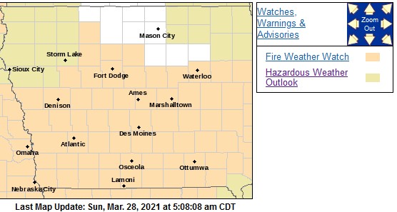 FIRE WEATHER WATCH IN EFFECT FROM MONDAY AFTERNOON THROUGH EARLY MONDAY EVENING FOR EXTREME FIRE CONDITIONS. The National Weather Service in Des Moines has issued a Fire Weather Watch FOR EXTREME FIRE CONDITIONS, which is in effect from Monday afternoon through early Monday evening.
* Relative Humidity…As low as 28 to 32 percent.
* Impacts…Any fires that start Monday afternoon may spread rapidly and become uncontrollable.
* WIND…Strong south to southwest winds with sustained speeds of 25 mph, and gusts of 45 mph possible.
* FUEL…Grasses and any lingering crop debris will dry out quickly in these conditions and may be able to burn easily.
PRECAUTIONARY/PREPAREDNESS ACTIONS…
A Fire Weather Watch means that critical fire weather conditions are forecast to occur. Listen for later forecasts and possible Red Flag Warnings.
Skyscan Forecast Saturday, March 27, 2021 Dan Hicks
Today: Mostly cloudy. Light rain or drizzle early. N @ 10-15. High 54.
Tonight: Partly cloudy. Light and variable winds. Low 30.
Sunday: Mostly sunny. S @ 10-20. High 60.
Sunday Night: Clear. S @ 5-10 with gusts to 20. Low 43.
Monday: Mostly sunny. High 73.
Tuesday: Mostly cloudy. A few showers. High 55.

Podcast: Play in new window | Download (696.9KB)
Subscribe: RSS
Today: Areas of fog this morning; Partly cloudy. High 58. SE @ 10 mph.
Tonight: Mostly cloudy w/rain. Low 40. SE winds becoming NE @ 5-10.
Tomorrow: Mo. Cldy w/rain ending in the morning. High 54. N @ 10-15.
Sunday: Mostly sunny. High around 60.
Monday: Mo. Sunny. High 73.
Thursday’s High in Atlantic was 45, and the Low was 38. We received just .01″ rain Thursday. Last year on this date the High in Atlantic was 60, and the Low was 42. The Record High on this date was 88 in 1907, and the Record Low was -2 in 1955.
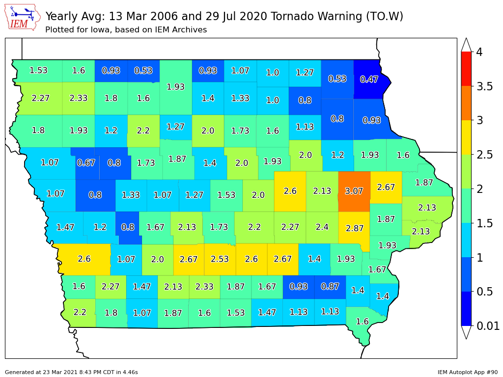
(National Weather Service/Des Moines) – The State of Iowa had its test tornado drill Wed., Mar 24th. In case you are wondering how common is it for a Tornado Warning to affect at least part of your county? The Iowa State University/Iowa Environmental Mesonet crunched the numbers from 2006 to 2020 to find out. (See the graphic) For many Iowans, tornadoes are the most frightening weather phenomena and something that many folks actively run practice drills for. The NWS issues a tornado warning when a tornado is observed and/or indicated to be imminent by Doppler RADAR. The featured map presents the average number of tornado warnings per year by county over the past 15 years.
Please note that the official warning presently are polygon geographies, but the counties are still used by some warning dissemination systems. Linn County (Cedar Rapids) shows up with the highest frequency on the map with other urban centers clearly visible as well. There are many complexities as to why such variability exists over the state, but distance from the nearest RADAR is an important aspect as the earth’s curvature causes the RADAR to miss the lowest parts (which are sometimes the rotating ones) as the beam travels further away from the RADAR site.
Today: Partly cloudy to cloudy w/scattered light rain. High 49. NE @ 10-15.
Tonight: P/Cldy. Low 30.
Tomorrow: Areas of morning fog; P/Cldy to Cloudy. High 58. SE @ 10.
Saturday: Mo. Cldy w/a chance of showers early in the day High 54.
Sunday: P/Cldy. High near 60.
Wednesday’s High in Atlantic was 42. Our Low this morning, 36. We received some light rain between 5-am and 7-a.m. today (Thu.), for a 24-hour total of .01″. Last year on this date the High in Atlantic was 58 and Low 41. The Record High on this date was 91 in 1907. The Record Low was 5, in 1894.
Today: Light rain or drizzle ending later this morning; Mostly cloudy. High 48. NW @ 15-30.
Tonight: P/Cldy to Cldy. Low 35. NW @ 5-10.
Tomorrow: P/Cldy to Cloudy w/isolated showers. High near 50. NE @ 10-15.
Friday: Mo. Cldy w/a chance of showers late in the day High 56.
Saturday: Mo. Cldy w/a chance of showers early. High near 56.
Tuesday’s High in Atlantic was 55. Our Low this morning, 42. Rainfall in Atlantic (at KJAN), from 7-a.m. Tuesday through 6-a.m. today, was .67”. Last year on this date the High in Atlantic was 55 and Low 42. The Record High on this date was 83 in 1967. The Record Low was -2, in 1974.
Iowa Homeland Security and Emergency Management and the National Weather Service have declared the week of March 22 through March 26, 2021 Severe Weather Awareness Week. Severe Weather Awareness Week is an annual event to remind Iowans that severe weather is part of being in Iowa and that understanding the risks and how to respond to them can save lives. The highlight of the week will be a statewide tornado drill on Wednesday, March 24th.
 For this drill, the National Weather Service in Des Moines will issue a mock tornado warning issued at approximately 11:00AM coinciding with weekly weather radio testing. Outdoor warning sirens will be sounded at or soon after 11:00AM in cities throughout Cass County, according to Mike Kennon, Cass County Emergency Management Coordinator. Also, those who subscribe to the Cass County Emergency Notification System will receive an alert concerning the drill. Kennon adds,”This is an excellent opportunity for residents, businesses, and schools to practice their own procedures in the event of a real severe weather event.”
In the event of actual severe weather occurring during or close to the drill time, the drill will be cancelled. To register for the Cass County Emergency Notification System, go to links located on the Cass County homepage or the Cass County EMA Facebook page. If you need assistance, contact Mike Kennon, Cass County Emergency Management Agency Coordinator at 712-243-1500.


