
(Radio Iowa) – Iowa’s weather during March was a far cry from the bitter cold of February. State climatologist Justin Glisan says the state ended the month with an average temperature of 42 degrees, which is six degrees warmer than normal. Precipitation for March, including snow and rain, was also above-average, with southwest Iowa getting up to an inch more than usual.
“Which is good for that part of the state, given drought conditions,” Glisan says. “Also, in north-central Iowa, we had some improvement in the U.S. Drought Monitor depiction, given that we did see timely rainfalls on several days during March. So, the statewide average was about 2.7 inches and that’s a little over six-tenths of an inch above average.” While it’s been chilly all week with lows dipping into the 20s, the forecast calls for a warming trend to begin tomorrow (Friday), with temperatures promising to bound into the 60s and 70s this weekend.
“We are definitely seeing a signal for warmer-than-average temperatures and we’re kind of see-sawing back and forth in terms of precipitation,” Glisan says. “There is a signal in the six-to-ten day outlook for wetter-than-normal conditions across the state, and then we look to dry out as we get into the second week of April.” The entire spring season may be trending toward more summer-like weather.
“We are seeing a strong signal for warmer-than-average temperatures for the April-May-June seasonal time slice,” Glisan says. “We’re still in that La Nina phase but we do have a 60-percent chance of transitioning into what we call the enso-neutral phase, which is right between El Nino and La Nina.” Forecasters say parts of Iowa may reach 80 degrees next week for the first time in 2021 and the first time since last fall.
The month of March, in Atlantic was much warmer and a little wetter than what we normally would see. Weather data compiled here at the KJAN Studios (The official National Weather Service reporting site), show the Average High last month was 56, compared to the normal average high of 48. Our Average Low in March was 30, four-degrees warmer than normal. And, we received a total of 3.06-inches of precipitation, most of which was in the form of rain (.2” fell as snow), and which was nearly seven-tenths (.7”) of an inch greater than the norm.
The warmest day, 76 degrees on March 10, broke the old record of 75 set in 2015. The coldest day was on the 31st (a 24-hour Low of 14).
Looking ahead to the month of April in Atlantic, we can expected an Average High of 62-degrees, an Average Low of 37, and rain/melted snow typically amounting to 3.43-inches. We’ll let you know if we were on par for those conditions…on May 1st.
Iowa Counties: Monona-Harrison-Shelby-Pottawattamie-Mills-Montgomery-Fremont-
Page–
409 AM CDT Thu Apr 1 2021
This Hazardous Weather Outlook is for portions of southwest Iowa…west central Iowa…east central Nebraska…northeast Nebraska and southeast Nebraska.
Today and Tonight: Fire danger could reach into the very high category this afternoon across portions of the area.
Friday through Wednesday: Fire danger could reach the very high category during the afternoons into early next week.
Today: Mostly sunny, not as windy. High near 50. S @ 5-10.
Tonight: Fair to Partly cloudy, not as cold. Low 33. S @ 5-10.
Tomorrow: P/Cldy & windy. High 66. SW @ 15-30.
Saturday: Mo. sunny. High 75.
Sunday: Mostly sunny. High 78.
Wednesday’s High in Atlantic was 45. Our Low this morning was 13. Last year on this date the High in Atlantic was 72 and Low 40. The Record High on this date was 87 in 2003. The Record Low was 14, in 1924.
Today: Mostly sunny & breezy. High 46. NW @ 10-20.
Tonight: Mostly clear. Low of 16. A light & variable breeze.
Tomorrow: Mostly sunny. High 51. SE @ 10.
Friday: Partly cloudy. High 68.
Friday: Mostly sunny. High 76.
Tuesday’s High in Atlantic was 52. Our Low this morning, 22. Last year on this date the High in Atlantic was 67 and Low 34. The Record High on this date was 87 in 2012. The Record Low was 12, in 1924.
Hazardous Weather Outlook
307 AM CDT Wed Mar 31 2021
This Hazardous Weather Outlook is for much of central and western Iowa….
Today and tonight: Breezy northwest winds and low humidities will continue to produce elevated fire weather conditions today.
Fire danger should rise into the very high category this afternoon over parts of western & southwest Iowa and eastern Nebraska, and could reach the extreme category for a few hours.
Monona-Harrison-Shelby-Pottawattamie Counties
1005 AM CDT Tue Mar 30 2021
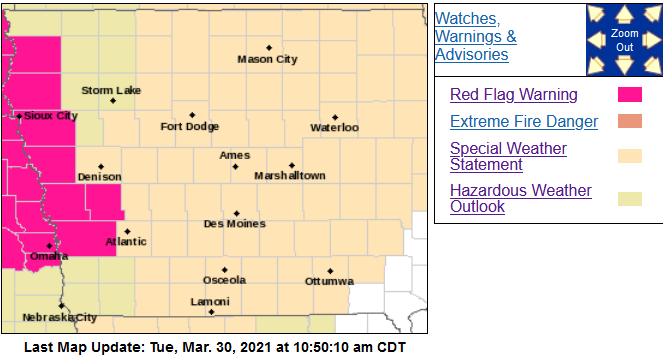 …RED FLAG WARNING IN EFFECT UNTIL 8 PM CDT THIS EVENING FOR WIND AND LOW RELATIVE HUMIDITY…
* Winds…Northwest 20 to 25 mph with gusts up to 35 mph.
* Relative Humidity…As low as 15 percent.
* Impacts…Any fires that ignite may spread rapidly and exhibit extreme fire behavior.
PRECAUTIONARY/PREPAREDNESS ACTIONS…
A Red Flag Warning means that critical fire weather conditions are either occurring now, or will shortly. A combination of strong winds, low relative humidity and warm temperatures can
contribute to extreme fire behavior.
For the rest of the area: Brisk Winds and Elevated Fire Danger Again Today. Although not as windy as Monday, northwest winds will still gust from 25 to 40 mph at times today. It will be cooler as well, but these winds will still combine with drying grasses and low humidities, as low as 25 to 35 percent by afternoon, to produce another day of elevated fire danger.
These winds may blow around unsecured objects and affect high profile vehicles. Also, conditions will be favorable for fires to develop and spread quickly, so avoid outdoor burning.
Today: Partly cloudy to cloudy w/a chance of sprinkles this morning. High 51. NW @ 20-40 mph slowly diminishing.
Tonight: Mostly clear w/a Low of 22. NW @ 5.
Tomorrow: Mostly sunny. High 46. NW @ 10-20.
Thursday: Mo. sunny. High 52.
Friday: P/Cldy. High 65.
Monday’s High in Atlantic was 76. Our Low this morning, 45. Last year on this date, the High in Atlantic was 69 and the Low was 25. The Record High was 87 in 1968, and the Record Low was 8 in 1964.
Today: Mostly Sunny & windy. High 73. S/SW @ 20-40 mph w/gusts to around 50 this afternoon. **RED FLAG WARNING & WIND ADVISORY from Noon until 8-p.m.**
Tonight: Increasing clouds w/a chance of light rain late. Low around 35. S @ 10-20 mph w/gusts to near 40 mph.
Tuesday: Mostly cloudy early w/a chance of morning showers; Becoming P/Cldy. High 51. NW @ 15-30.
Wednesday: Mo. Sunny & breezy, with a high near 46.
Thursday: Mo. Sunny, with a high near 52.
Sunday’s High in Atlantic was 56. Our Low was 31. Last year on this date the High in Atlantic was 59 and Low 24. The Record High on this date was 90 in 1896. The Record Low was 5, in 1969.
A RED FLAG WARNING is in effect from Noon today (Monday) until late this evening all but extreme northeast Iowa, and far western Nebraska, for Extreme Fire Weather Conditions. In addition, a WIND ADVISORY remains in effect from Noon today until late this evening. A combination of warming temperatures, strong southerly wind, low relative humidity, and relatively dry prairie grasses and other fuels will create extreme fire weather conditions. Any fires that start this afternoon may spread rapidly and become uncontrollable.
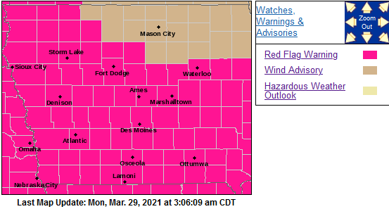
Red Flag Warning for counties shaded in pink
* Relative Humidity…Minimum relative humidity between 20 and 30 percent during the afternoon.
* WIND…Strong south to southwest winds with sustained speeds of 25 to 35 mph, with gusts over 50 mph possible.
* FUEL…Prairie grasses and any lingering crop debris will dry out quickly in these conditions and may be able to burn easily and lead to extremely fast fire growth.
PRECAUTIONARY/PREPAREDNESS ACTIONS…
A Red Flag Warning means that critical fire weather conditions are either occurring now, or will shortly. A combination of
strong winds, low relative humidity, and warm temperatures can contribute to extreme fire behavior.


