
330 AM CDT SUN JUN 30 2013
EARLY THIS MORNING…MOSTLY CLEAR. NORTH WIND 5 TO 10 MPH.
TODAY…PARTLY SUNNY. HIGH IN THE UPPER 70S. NORTHEAST WIND 10 TO 15 MPH WITH GUSTS TO AROUND 25 MPH.
TONIGHT…MOSTLY CLEAR. LOW IN THE MID 50S. NORTH WIND 5 TO 10 MPH.
MONDAY…MOSTLY SUNNY. HIGH IN THE UPPER 70S. NORTHEAST WIND 5 TO 15 MPH.
TUESDAY…PARTLY SUNNY. HIGH IN THE UPPER 70S. NORTHEAST WIND 5 TO 10 MPH.
WEDNESDAY…PARTLY SUNNY WITH A 20 PERCENT CHANCE OF THUNDERSTORMS. HIGH IN THE UPPER 70S.
INDEPENDENCE DAY…PARTLY SUNNY WITH A 20 PERCENT CHANCE OF THUNDERSTORMS. HIGH IN THE LOWER 80S.
THURSDAY NIGHT AND FRIDAY…PARTLY CLOUDY. LOW IN THE MID 60S. HIGH IN THE MID 80S.
COUNTIES:CRAWFORD-CARROLL-GREENE-AUDUBON-GUTHRIE-DALLAS-CASS-ADAIR-MADISON-ADAMS-UNION-TAYLOR-RINGGOLD-
134 PM CDT SAT JUN 29 2013
…CONDITIONS ARE FAVORABLE FOR FUNNEL CLOUDS…
CURRENT ATMOSPHERIC CONDITIONS SUPPORT THE DEVELOPMENT OF FUNNEL CLOUDS. USUALLY…THESE FUNNEL CLOUDS CAN FORM FROM SHOWERS AND WEAK THUNDERSTORMS. THESE FUNNELS ARE NORMALLY BRIEF…DROP ONLY A FEW HUNDRED FEET FROM THE CLOUD BASE…AND RARELY BECOME A TORNADO OR CAUSE DAMAGE. HOWEVER…IF ONE IS SPOTTED…PLEASE REPORT IT IMMEDIATELY TO LOCAL LAW ENFORCEMENT FOR RELAY TO THE NATIONAL WEATHER SERVICE. IF A TORNADO WARNING WOULD BECOME NECESSARY…TAKE APPROPRIATE ACTION.
715 AM CDT SAT JUN 29 2013
TODAY…PARTLY SUNNY. ISOLATED THUNDERSTORMS BEFORE NOON. SCATTERED SHOWERS AND ISOLATED THUNDERSTORMS IN THE AFTERNOON. BREEZY. HIGH IN THE UPPER 70S. NORTH WIND 10 TO 25 MPH. CHANCE OF PRECIPITATION 50 PERCENT.
TONIGHT…PARTLY CLOUDY. A CHANCE OF SHOWERS AND ISOLATED THUNDERSTORMS IN THE EVENING. LOW IN THE UPPER 50S. NORTH WIND 5 TO 10 MPH. GUSTS UP TO 20 MPH THROUGH MIDNIGHT. CHANCE OF PRECIPITATION 30 PERCENT.
SUNDAY…PARTLY SUNNY. HIGH IN THE MID 70S. NORTHEAST WIND 5 TO 15 MPH.
SUNDAY NIGHT…MOSTLY CLEAR. LOW IN THE MID 50S. NORTH WIND 5 TO 10 MPH.
MONDAY...MOSTLY SUNNY. HIGH IN THE UPPER 70S. NORTHEAST WIND 5 TO 10 MPH.
MONDAY NIGHT…MOSTLY CLEAR. LOW IN THE MID 50S.
TUESDAY AND TUESDAY NIGHT…PARTLY CLOUDY. HIGH IN THE UPPER 70S. LOW IN THE UPPER 50S.
WEDNESDAY…PARTLY SUNNY WITH A 20 PERCENT CHANCE OF THUNDERSTORMS. HIGH IN THE UPPER 70S.
Today: Sunny. High 85. Gusty winds out of the NW @ 10-20 with gusts up to 30.
Tonight: Clear. Low 62. NW @ 10-15.
Saturday: Partly Cloudy. Scattered showers, thunderstorms possible in the afternoon. High 78. N @ 15.
Saturday Night: Partly Cloudy. Low in the upper 50’s.
Sunday: Partly Cloudy. High 75. NE @ 10.
Monday: Partly Cloudy. High upper 70’s.
Tuesday: Partly Cloudy. High upper 70’s.
Podcast: Play in new window | Download (647.8KB)
Subscribe: RSS
Today: Scattered Showers and thunderstorms. Partly cloudy with a High of 88. Calm winds becoming 5-10mph.
Tonight: Partly cloudy with a Low of 65. Winds NW at 10-15.
Friday: Sunny with a High of 85. Winds NW at 10.
Friday Night: Clear. Low 62. Winds NW at 10-15
Saturday: Partly cloudy to cloudy. Scattered showers possible. High 78. Winds NNW at 10-15
Sunday: Partly sunny. Slight chance of a shower. High 77.
Monday: Sunny. H 78.
Podcast: Play in new window | Download (706.2KB)
Subscribe: RSS
Today: Scattered Showers early then Partly Sunny with a high near 90. Breezy with a south wind at 10-15mph with gusts as high as 25.
Tonight: A slight chance of showers and thunderstorms, mainly between 9pm and 1am. Partly cloudy with a low around 70. South winds at 5-15.
Wednesday: Sunny with a high near 89. West northwest winds at 10-15 with gusts as high as 20.
Thursday: Mostly sunny with a high near 88. Northwest winds at 5-10.
Friday: Sunny with a high of 86.
Saturday: Mostly sunny with a high in the low 80’s.
Podcast: Play in new window | Download (696.7KB)
Subscribe: RSS
THE NATIONAL WEATHER SERVICE IN OMAHA, NE HAS ISSUED A
* FLOOD ADVISORY FOR
  THE EAST NISHNABOTNA RIVER AT RED OAK.
* UNTIL TUESDAY EVENING.
* AT  815 PM MONDAY THE STAGE WAS 17.2 FEET.
* FLOOD STAGE IS 18.0 FEET.
* FORECAST...THE RIVER WILL RISE TO NEAR 17.9 FEET EARLY TUESDAY
  MORNING.
* IMPACT...AT 18.0 FEET...RURAL LOWLANDS BEGIN TO FLOOD ALONG THE
  EAST BANK.
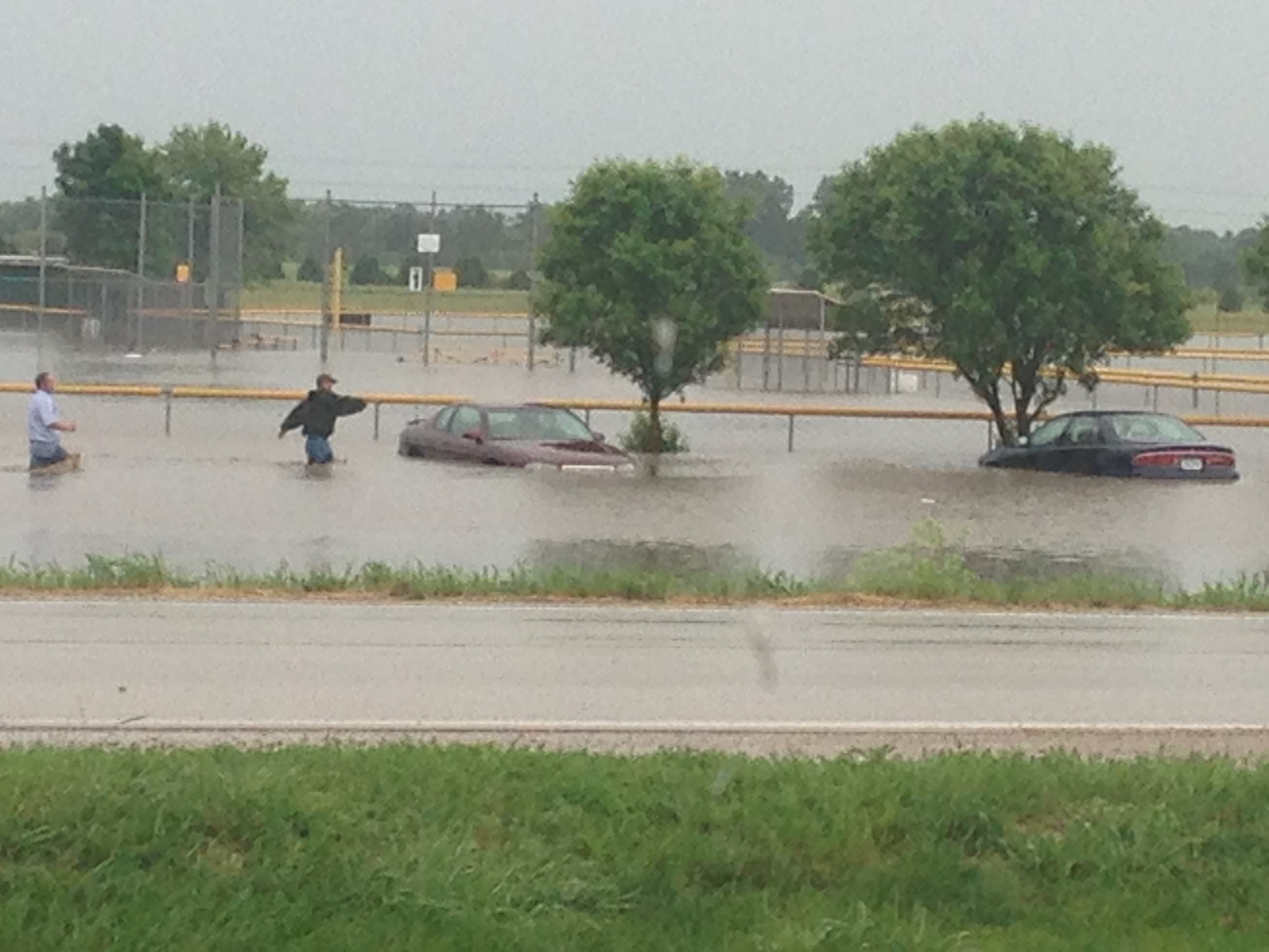
Heavy rains, flooding and high winds caused a bit of damage Monday morning. Storms packing winds of up to 70 miles per hour were reported in a number of locations. The heavy rains have caused some low-lying areas that were already threatened by recent rains to swell as creeks and streams couldn’t hold the added water. Flooding at the Atlantic little league complex caused a problem for those who park their cars in the lot and commute to the Menard’s Shipping Warehouse at Shelby. You can see in the picture that people are trying to get to some of the cars in waist-deep water to move them out of harms way. High winds were reported in several locations….58 mph at the Atlantic airport, 60 mph in Audubon and 75 mph in Harlan. The winds caused considerable tree damage. There was a report of a barn blown over north of Atlantic and a semi blown on its side on Highway 141 in Greene county.
FLASH FLOOD WARNING until 8-a.m.: NE Cass, SE Audubon & SW Guthrie Counties.
FLASH FLOOD WATCH until 4-p.m. for Cass, Adair, Adams, Audubon, Carroll, Crawford,Dallas, Guthrie & Madison Counties.
Monday: Showers and thunderstorms likely, mainly before 2pm. Partly sunny, with a high near 87. Breezy, with a south wind 8 to 17 mph, with gusts as high as 25 mph. Chance of precipitation is 70%. New rainfall amounts between a quarter and half of an inch possible.
Monday Night: A 20 percent chance of showers and thunderstorms after 11pm. Partly cloudy, with a low around 71. South wind 13 to 15 mph, with gusts as high as 21 mph.
Tuesday: Mostly sunny, with a high near 93. Heat index values as high as 102. Windy, with a south wind 14 to 22 mph, with gusts as high as 30 mph.
Tuesday Night: Partly cloudy, with a low around 72. Breezy, with a south wind 6 to 16 mph, with gusts as high as 23 mph.
Wednesday: Sunny, with a high near 91. Breezy.
Wednesday Night: Mostly clear, with a low around 71.
Thursday: Sunny, with a high near 90.
Thursday Night: Partly cloudy, with a low around 69.
Friday: Sunny, with a high near 87.
AREA COUNTIES: CRAWFORD-CARROLL-AUDUBON-GUTHRIE-
DALLAS-CASS-ADAIR-MADISON-
341 AM CDT MON JUN 24 2013
…FLASH FLOOD WATCH IN EFFECT THROUGH 4-p.m…..
* THUNDERSTORMS WILL MOVE ACROSS CENTRAL IOWA…MAINLY BETWEEN
INTERSTATE 80 AND HIGHWAY 20…EARLY THIS MORNING. A SECOND
ROUND OF STORMS WILL ORIENTED MORE NORTH TO SOUTH LATER THIS
MORNING AND AFTERNOON BUT WILL MOVE ACROSS THE SAME GENERAL
AREA. RAINFALL RATES OF 2 TO 3 INCHES AN HOUR ARE LIKELY WITH
THESE STORMS.
* RAINFALL RATES OF 2 OR MORE INCHES AN HOUR MAY CAUSE FLASH
FLOODING OF CREEKS AND STREAMS ALONG WITH THE POTENTIAL FOR
URBAN FLOODING.
PRECAUTIONARY/PREPAREDNESS ACTIONS…
A FLASH FLOOD WATCH MEANS THAT CONDITIONS MAY DEVELOP THAT LEAD
TO FLASH FLOODING. FLASH FLOODING IS A VERY DANGEROUS SITUATION.
YOU SHOULD MONITOR LATER FORECASTS AND BE PREPARED TO TAKE ACTION
SHOULD FLASH FLOOD WARNINGS BE ISSUED.


