
Scattered thunderstorms are forecast tonight and Monday. The threat for severe weather is low, but a few storms may generate some hail and gusty winds.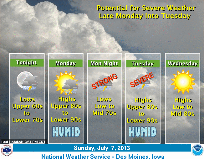 Humidity will be high with warm and muggy conditions expected from Monday through Tuesday. Thunderstorm chances will increase overnight Monday night and again Tuesday afternoon into Tuesday night. There is a threat of severe weather during these periods with large hail and damaging wind the primary threats. Slightly cooler and less humid weather will then arrive for the latter half of the work week along with lower rain chances.
400 AM CDT SUN JUL 7 2013
EARLY THIS MORNING...PARTLY CLOUDY WITH ISOLATED THUNDERSTORMS. SOUTH WIND 5 TO 15 MPH. CHANCE OF THUNDERSTORMS 20 PERCENT.
TODAY…PARTLY SUNNY. HIGH IN THE LOWER 90S. SOUTHWEST WIND 5 TO 15 MPH.
TONIGHT…PARTLY CLOUDY. A 20 PERCENT CHANCE OF THUNDERSTORMS OVERNIGHT. LOW AROUND 70. SOUTH WIND NEAR 5 MPH.
MONDAY…PARTLY SUNNY WITH A 30 PERCENT CHANCE OF THUNDERSTORMS. HIGH AROUND 90. SOUTH WIND AROUND 5 MPH.
MONDAY NIGHT…PARTLY CLOUDY THROUGH MIDNIGHT THEN BECOMING MOSTLY CLOUDY. A 50 PERCENT CHANCE OF THUNDERSTORMS. LOW IN THE LOWER 70S. SOUTH WIND 5 TO 10 MPH.
TUESDAY…PARTLY SUNNY WITH A 50 PERCENT CHANCE OF THUNDERSTORMS. HIGH IN THE LOWER 90S. SOUTHWEST WIND 5 TO 10 MPH. HIGHEST HEAT INDEX READINGS 100 TO 105 IN THE AFTERNOON.
TUESDAY NIGHT…PARTLY CLOUDY WITH A 50 PERCENT CHANCE OF THUNDERSTORMS. LOW AROUND 70.
WEDNESDAY…PARTLY SUNNY. HIGH IN THE MID 80S.
The National Weather Service forecast (podcast) for the KJAN listening area and weather information for Atlantic….
Podcast: Play in new window | Download (869.7KB)
Subscribe: RSS
346 AM CDT SAT JUL 6 2013
EARLY THIS MORNING…PARTLY CLOUDY. SOUTH WIND AROUND 10 MPH.
TODAY…PARTLY SUNNY. BREEZY. HIGH IN THE UPPER 80S. SOUTH WIND 10 TO 20 MPH.
TONIGHT…PARTLY CLOUDY WITH A 30 PERCENT CHANCE OF THUNDERSTORMS. LOW IN THE UPPER 60S. SOUTH WIND 10 TO 15 MPH. GUSTS UP TO 25 MPH THROUGH MIDNIGHT.
SUNDAY…PARTLY SUNNY. A 20 PERCENT CHANCE OF THUNDERSTORMS THROUGH MID MORNING. HIGH AROUND 90. SOUTH WIND 5 TO 15 MPH.
SUNDAY NIGHT…PARTLY CLOUDY WITH A 30 PERCENT CHANCE OF THUNDERSTORMS. LOW AROUND 70. SOUTH WIND NEAR 5 MPH.
MONDAY…PARTLY SUNNY WITH A 20 PERCENT CHANCE OF THUNDERSTORMS. HIGH AROUND 90. SOUTH WIND NEAR 5 MPH.
MONDAY NIGHT…THUNDERSTORMS LIKELY. LOW IN THE LOWER 70S. CHANCE OF THUNDERSTORMS 60 PERCENT.
TUESDAY…MOSTLY CLOUDY WITH A 50 PERCENT CHANCE OF THUNDERSTORMS. HIGH IN THE UPPER 80S.
The Freese-Notis (podcast) forecast for Atlantic & the KJAN listening area, and weather information for Atlantic….
Podcast: Play in new window | Download (705.6KB)
Subscribe: RSS
AREA COUNTIES: SAC-CRAWFORD-CARROLL-GREENE-AUDUBON-GUTHRIE-DALLAS-CASS-ADAIR-MADISON….500 AM CDT FRI JUL 5 2013
TODAY AND TONIGHT…
AN ISOLATED THUNDERSTORM IS POSSIBLE LATE TONIGHT. THE SEVERE WEATHER THREAT IS MINIMAL. SMALL HAIL…GUSTY WINDS…AND LOCALLY HEAVY RAINFALL WILL BE POSSIBLE WITH ANY STRONGER STORM.
SATURDAY THROUGH THURSDAY….
THUNDERSTORM CHANCES ARE POSSIBLE SATURDAY NIGHT THROUGH TUESDAY NIGHT. THE SEVERE WEATHER THREAT IS STILL UNCERTAIN…HOWEVER ANY SEVERE WEATHER OR HEAVY RAIN CHANCES LOOK MORE LIKELY MONDAY THROUGH TUESDAY NIGHT.
315 AM CDT FRI JUL 5 2013
EARLY THIS MORNING…MOSTLY CLEAR. SOUTH WIND 5 TO 10 MPH.
TODAY…PARTLY SUNNY. BREEZY. HIGH IN THE UPPER 80S. SOUTH WIND 10 TO 20 MPH.
TONIGHT…PARTLY CLOUDY. LOW IN THE UPPER 60S. SOUTH WIND 10 TO 15 MPH.
SATURDAY…PARTLY SUNNY. BREEZY. HIGH IN THE MID 80S. SOUTH WIND 10 TO 20 MPH.
SATURDAY NIGHT…PARTLY CLOUDY THROUGH MIDNIGHT THEN BECOMING MOSTLY CLOUDY. A 30 PERCENT CHANCE OF THUNDERSTORMS. LOW IN THE UPPER 60S. SOUTH WIND 10 TO 15 MPH.
SUNDAY…PARTLY SUNNY WITH A 20 PERCENT CHANCE OF THUNDERSTORMS. HIGH IN THE UPPER 80S. SOUTH WIND 10 TO 15 MPH.
SUNDAY NIGHT AND MONDAY…PARTLY CLOUDY. A 40 PERCENT CHANCE OF THUNDERSTORMS. LOW IN THE LOWER 70S. HIGH IN THE UPPER 80S.
MONDAY NIGHT AND TUESDAY…MOSTLY CLOUDY WITH A 40 PERCENT CHANCE OF THUNDERSTORMS. LOW IN THE LOWER 70S. HIGH IN THE UPPER 80S.
The latest forecast (Podcast) for the KJAN listening area & weather information for Atlantic…
Podcast: Play in new window | Download (894.2KB)
Subscribe: RSS
EARLY THIS MORNING…MOSTLY CLEAR. SOUTH WIND NEAR 5 MPH.
TODAY…MOSTLY SUNNY. HIGH IN THE MID 80S. SOUTH WIND 5 TO 15 MPH.
TONIGHT…MOSTLY CLEAR. LOW IN THE LOWER 60S. SOUTH WIND 5 TO 10 MPH.
FRIDAY…MOSTLY SUNNY. HIGH IN THE MID 80S. SOUTH WIND 10 TO 15 MPH WITH GUSTS TO AROUND 25 MPH.
FRIDAY NIGHT AND SATURDAY…PARTLY CLOUDY. BREEZY. LOW IN THE UPPER 60S. HIGH IN THE MID 80S. SOUTH WIND 10 TO 20 MPH WITH GUSTS TO AROUND 30 MPH.
SATURDAY NIGHT…PARTLY CLOUDY WITH A 50 PERCENT CHANCE OF THUNDERSTORMS. LOW IN THE UPPER 60S.
SUNDAY…PARTLY SUNNY WITH A 20 PERCENT CHANCE OF THUNDERSTORMS. HIGH IN THE UPPER 80S.
Now that July has arrived, we’re out of the peak season for tornadoes in Iowa, although twisters can strike during any month of the year. Jeff Johnson, warning coordination meteorologist at the National Weather Service, says the state’s tornado tally is well below average for the year so far, not that anyone’s complaining. “The tornado numbers were still a little bit down compared to normal,” Johnson says. “We had ten and we average probably 30 every year, so our numbers were a little bit down but still we had some significant storms.” Based on the forecast, this holiday week’s weather shouldn’t include anything severe, but Johnson notes, that can always change in a hurry.
“We can get severe weather in July and August, even right on through the late fall,” Johnson says. “Even in November, it’s not unprecedented to get tornadoes. Remember Stratford here in ’05. We’re not out of the woods but we’re beyond the peak season and we still have to keep our guard out.” Iowa’s first tornado this year struck on May 19th. The previous confirmed tornado touchdown in the state was 358 days prior. It set a record for the longest time Iowa’s been tornado-free in more than 60 years of record-keeping.
(Radio Iowa)


