201 AM CDT MON JUN 24 2013
THE NATIONAL WEATHER SERVICE IN DES MOINES HAS ISSUED A FLASH FLOOD WARNING FOR…
NORTHEASTERN CASS COUNTY IN SOUTHWEST IOWA…SOUTHERN AUDUBON COUNTY IN WEST CENTRAL IOWA…SOUTHWESTERN GUTHRIE COUNTY IN WEST CENTRAL IOWA…UNTIL 800 AM CDT
* AT 159 AM CDT…NATIONAL WEATHER SERVICE DOPPLER RADAR INDICATED SLOW MOVING THUNDERSTORMS WITH VERY HEAVY RAINFALL ACROSS THE WARNED AREA. ESTIMATED RAINFALL OF 2 TO 3 INCHES HAS LIKELY FALLEN SINCE MIDNIGHT…AND ANOTHER 1 TO 2 INCHES OF RAIN COULD FALL NORTH OF ADAIR AND EAST OF EXIRA BY 4 AM.
* RUNOFF FROM THIS EXCESSIVE RAINFALL WILL CAUSE FLASH FLOODING TO OCCUR. FLASH FLOODING IS EXPECTED TO OCCUR OVER MAINLY RURAL AREAS OF NORTHEASTERN CASS…SOUTHERN AUDUBON AND SOUTHWESTERN GUTHRIE COUNTIES…INCLUDING THE TOWNS OF ANITA…BRAYTON…EXIRA AND KIMBALLTON. THE WARNING INCLUDES A LARGE STRETCH OF I-80.
PRECAUTIONARY/PREPAREDNESS ACTIONS…
EXCESSIVE RUNOFF FROM HEAVY RAINFALL WILL CAUSE FLOODING OF SMALL CREEKS AND STREAMS…COUNTRY ROADS…AS WELL AS FARMLAND ALONG THE BANKS OF CREEKS AND STREAMS. BE ESPECIALLY CAUTIOUS AT NIGHT WHEN IT IS HARDER TO RECOGNIZE THE DANGERS OF FLOODING. IF FLASH FLOODING IS OBSERVED ACT QUICKLY. DO NOT ENTER THE WATER. TURN AROUND AND MOVE UP TO HIGHER GROUND TO ESCAPE FLOOD WATERS. DO NOT STAY IN AREAS SUBJECT TO FLOODING WHEN WATER BEGINS RISING.
…FLASH FLOOD WATCH IS CANCELLED…
THE FLASH FLOOD WATCH FOR PORTIONS OF CENTRAL IOWA…NORTH
CENTRAL IOWA…NORTHEAST IOWA…NORTHWEST IOWA AND WEST CENTRAL
IOWA HAS BEEN CANCELLED. THUNDERSTORMS THAT MOVE THROUGH EARLIER
TODAY HAVE PUSHED A FRONTAL BOUNDARY SOUTH OF THE STATE.
THUNDERSTORMS ARE LIKELY TO FORM ALONG THIS BOUNDARY AND SPREAD
NORTH TONIGHT…HOWEVER THE HEAVIEST RAINFALL IS LIKELY TO REMAIN
SOUTH OF IOWA TONIGHT.
1031 AM CDT SUN JUN 23 2013 AREA COUNTIES: AUDUBON, GUTHRIE, DALLAS, CRAWFORD, CARROLL AND GREENE….
…FLASH FLOOD WATCH NOW IN EFFECT FROM 7 PM CDT THIS EVENING THROUGH MONDAY MORNING…
SEVERAL ROUNDS OF THUNDERSTORMS ARE POSSIBLE TONIGHT. RAINFALL AMOUNTS MAY TOTAL 2 TO 3 INCHES WITH ISOLATED AMOUNTS OF 4 OR MORE INCHES OF RAIN BY MONDAY MORNING IN SOME LOCATIONS. AT THIS TIME THE NORTHERN TWO THIRDS OF CENTRAL IOWA IS FAVORED FOR THE HEAVIER RAINFALL. THE AREA OF HEAVY RAIN AND POTENTIAL FOR FLASH FLOODING MAY BE EXPANDED SOUTH INTO SOUTHERN IOWA FOR LATER TONIGHT.
THUNDERSTORMS ARE EXPECTED TO REDEVELOP OVER THE AREA TONIGHT AND STRENGTHEN AS THEY MOVE SOUTH. RAINFALL RATES OF SEVERAL INCHES PER HOUR MAY CAUSE FLASH FLOODING OF CREEKS AND STREAMS ALONG WITH THE POTENTIAL FOR URBAN FLASH FLOODING.
PRECAUTIONARY/PREPAREDNESS ACTIONS...
A FLASH FLOOD WATCH MEANS THAT CONDITIONS MAY DEVELOP THAT LEAD TO FLASH FLOODING. FLASH FLOODING IS A VERY DANGEROUS SITUATION. YOU SHOULD MONITOR LATER FORECASTS AND BE PREPARED TO TAKE ACTION SHOULD FLASH FLOOD WARNINGS BE ISSUED.
AUDUBON-GUTHRIE-DALLAS-CASS-ADAIR-MADISON-ADAMS-UNION- TAYLOR-RINGGOLD-
628 AM CDT SUN JUN 23 2013
…THUNDERSTORMS WITH BRIEF HEAVY RAIN AND GUSTY WINDS…
A LINE OF THUNDERSTORMS WITH BRIEF HEAVY RAINFALL AND WINDS
GUSTING TO 30 TO 45 MPH WILL MOVE ACROSS THE AREA BETWEEN 630 AM
CDT AND 830 AM CDT THIS SUNDAY MORNING. RAINFALL AMOUNTS MAY REACH
ONE HALF TO AN INCH IN A SHORT PERIOD OF TIME AS THE STORMS PASS
YOUR AREA. EXPECT DANGEROUS LIGHTNING ALONG WITH THE STORMS EARLY
THIS MORNING.
THE BRIEF HEAVY RAINFALL MAY CAUSE PONDING OF WATER AND LOCALIZED
RISES IN STREAMS AND CREEKS EARLY TODAY.
ADDITIONAL THUNDERSTORMS ARE POSSIBLE LATER TODAY. SOME OF THE
STORMS MAY BE STRONG WITH LOCALLY HEAVY RAINFALL OVER PORTIONS OF
CENTRAL AND NORTHERN IOWA.
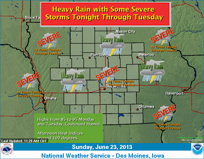
Warm and humid conditions will persist over Iowa through at least the first part of next week. Highs will range from the mid 80s to the mid 90s with lows overnight in the 70s. There will be periods of thunderstorms through Tuesday.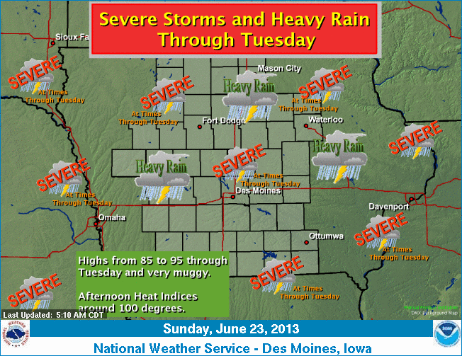 The most likely time for storms will be late afternoon through the night and into the early morning hours. Some severe storms are possible as well as heavy rainfall. At this point…Sunday and Sunday night appear to have the best chances for more widespread thunderstorms…heavy rainfall and severe storms.
430 AM CDT SUN JUN 23 2013
EARLY THIS MORNING…PARTLY CLOUDY WITH A 50 PERCENT CHANCE OF THUNDERSTORMS. SOUTH WIND 10 TO 15 MPH.
TODAY…MOSTLY CLOUDY. A CHANCE OF THUNDERSTORMS IN THE MORNING… THEN THUNDERSTORMS LIKELY IN THE AFTERNOON. BREEZY. SOME THUNDERSTORMS MAY PRODUCE HEAVY RAINFALL IN THE AFTERNOON. HIGH IN THE UPPER 80S. SOUTH WIND 10 TO 20 MPH. CHANCE OF THUNDERSTORMS 70 PERCENT.
TONIGHT…MOSTLY CLOUDY WITH A 40 PERCENT CHANCE OF THUNDERSTORMS UNTIL EARLY MORNING…THEN PARTLY CLOUDY EARLY IN THE MORNING. LOW IN THE LOWER 70S. SOUTH WIND 5 TO 15 MPH.
MONDAY…PARTLY SUNNY. A SLIGHT CHANCE OF THUNDERSTORMS THROUGH MID MORNING. A SLIGHT CHANCE OF THUNDERSTORMS LATE IN THE AFTERNOON. HIGH AROUND 90. SOUTH WIND 5 TO 15 MPH. CHANCE OF THUNDERSTORMS 20 PERCENT.
MONDAY NIGHT AND TUESDAY…PARTLY CLOUDY. BREEZY. LOW IN THE LOWER 70S. HIGH IN THE LOWER 90S. SOUTH WIND 10 TO 20 MPH. HEAT INDEX READINGS AROUND 100.
TUESDAY NIGHT…PARTLY CLOUDY. LOW IN THE MID 70S.
WEDNESDAY AND WEDNESDAY NIGHT...MOSTLY CLEAR. HIGH IN THE LOWER 90S. LOW IN THE LOWER 70S.
AREA COUNTIES: CRAWFORD-CARROLL–AUDUBON-GUTHRIE-DALLAS….
345 AM CDT SUN JUN 23 2013
…HEAVY RAIN AND FLASH FLOODING POSSIBLE THIS AFTERNOON THROUGH TONIGHT…
A COOL FRONT AND STORM SYSTEM OVER THE PLAINS WILL COMBINE TO INCREASE THUNDERSTORM CHANCES THIS AFTERNOON AND TONIGHT ACROSS CENTRAL IOWA. THERE MAY BE SEVERAL ROUNDS OF THUNDERSTORMS FROM THIS AFTERNOON THROUGH TONIGHT. AMPLE MOISTURE IN THE ATMOSPHERE
…FLASH FLOOD WATCH IN EFFECT FROM 1 PM CDT THIS AFTERNOON THROUGH MONDAY MORNING…
* SEVERAL ROUNDS OF THUNDERSTORMS ARE POSSIBLE TODAY AND TONIGHT. RAINFALL AMOUNTS MAY TOTAL 2 TO 3 INCHES WITH ISOLATED AMOUNTS OF 4 OR MORE INCHES OF RAIN BY MONDAY MORNING IN SOME LOCATIONS. AT THIS TIME THE NORTHERN TWO THIRDS OF CENTRAL IOWA ARE FAVORED FOR THE HEAVIER RAINFALL. THE AREA OF HEAVY RAIN AND POTENTIAL FOR FLASH FLOODING MAY BE EXPANDED SOUTH INTO SOUTHERN IOWA FOR LATER TODAY AND TONIGHT.
* THUNDERSTORMS ARE EXPECTED TO INCREASE BY EARLY AFTERNOON OVER NORTHERN IOWA AND STRENGTHEN AS THEY MOVE SOUTH THIS AFTERNOON AND TONIGHT WHEN THE POTENTIAL FOR FLASH FLOODING WILL BE THE GREATEST. RAINFALL RATES OF SEVERAL INCHES PER HOUR MAY CAUSE FLASH FLOODING OF CREEKS AND STREAMS ALONG WITH THE POTENTIAL FOR URBAN FLASH FLOODING.
PRECAUTIONARY/PREPAREDNESS ACTIONS…
A FLASH FLOOD WATCH MEANS THAT CONDITIONS MAY DEVELOP THAT LEAD TO FLASH FLOODING. FLASH FLOODING IS A VERY DANGEROUS SITUATION. YOU SHOULD MONITOR LATER FORECASTS AND BE PREPARED TO TAKE ACTION SHOULD FLASH FLOOD WARNINGS BE ISSUED.
AREA COUNTIES: CASS-ADAIR-MADISON-ADAMS-UNION-TAYLOR-RINGGOLD…
417 AM CDT SUN JUN 23 2013
TODAY AND TONIGHT…THUNDERSTORMS ARE EXPECTED ACROSS THE AREA THIS MORNING THEN AGAIN THIS AFTERNOON AND TONIGHT. SOME STORMS THIS AFTERNOON AND TONIGHT MAY BE SEVERE WITH LARGE HAIL AND WIND GUSTS TO 60 MPH THE MAIN THREATS. LOCALLY HEAVY RAINFALL IS ALSO POSSIBLE.
MONDAY THROUGH SATURDAY…THUNDERSTORMS ARE AGAIN POSSIBLE AT TIMES MONDAY THROUGH TUESDAY. SOME STORMS MAY BE SEVERE WITH LARGE HAIL AND DAMAGING WIND THE MAIN THREATS. ON AND OFF THUNDERSTORM CHANCES WILL EXIST OVER THE AREA FOR THE REMAINDER OF THE EXTENDED. IT IS TOO EARLY TO DETERMINE TIMING AND SEVERE POTENTIAL FOR THE REMAINDER OF THE PERIOD AT THIS TIME.
.SPOTTER INFORMATION STATEMENT…
SPOTTER ACTIVATION MAY BE NEEDED AT TIMES THROUGH TUESDAY.
Today Mostly sunny, with a high near 91. Windy, with a south wind 10 to 15 mph increasing to 15 to 25 mph in the afternoon. Winds could gust as high as 30 mph.
Tonight Partly cloudy, with a low around 73. Breezy, with a south wind 15 to 20 mph, with gusts as high as 25 mph.
Sunday A slight chance of showers and thunderstorms before 10am, then a chance of showers and thunderstorms after 4pm. Partly sunny, with a high near 89. Windy, with a south wind 15 to 25 mph, with gusts as high as 30 mph.
Sunday Night Chance of showers and thunderstorms, mainly before 1am. Mostly cloudy, with a low around 71. South wind 5 to 10 mph. New rainfall amounts between a quarter and half of an inch possible.
Monday Partly sunny, with a high near 89. South wind 5 to 15 mph, with gusts as high as 20 mph.
Tuesday Mostly sunny, with a high near 90. Breezy.
Wednesday Mostly sunny, with a high near 92
Podcast: Play in new window | Download (788.4KB)
Subscribe: RSS