
COUNTIES IN THE KJAN LISTENING AREA: SAC-CRAWFORD-CARROLL-AUDUBON-GUTHRIE-DALLAS-CASS-ADAIR-MADISON-ADAMS-UNION-TAYLOR-RINGGOLD
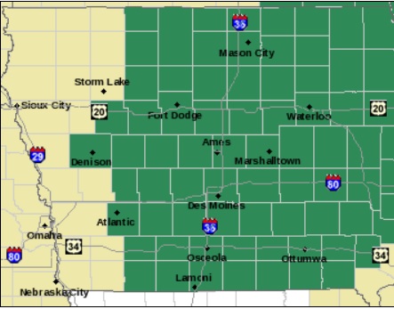
Counties shown in green are included in the Flash Flood Watch. (9/9-10)
356 AM CDT TUE SEP 9 2014
FLASH FLOOD WATCH IN EFFECT FROM 7-P.M. THIS EVENING THROUGH 7-A.M. WEDNESDAY.
WIDESPREAD RAINFALL AMOUNTS OF 1 TO 2 INCHES CAN BE EXPECTED ACROSS CENTRAL IOWA TONIGHT…WITH LOCALLY HIGHER AMOUNTS OF 3 INCHES OR MORE POSSIBLE.
FLASH FLOODING IS POSSIBLE ACROSS THE REGION. SIGNIFICANT PONDING IN URBAN AREAS IS POSSIBLE. IN ADDITION…SMALL STREAMS MAY RISE ABOVE THEIR BANKS AND CAUSE FLOODING OF LOW LYING AREAS INCLUDING ROADWAYS. FLASH FLOODING AT NIGHT IS EXTREMELY DANGEROUS.
PRECAUTIONARY/PREPAREDNESS ACTIONS…
A FLASH FLOOD WATCH MEANS THAT CONDITIONS MAY DEVELOP THAT LEAD TO FLASH FLOODING. FLASH FLOODING IS A VERY DANGEROUS SITUATION. YOU SHOULD MONITOR LATER FORECASTS AND BE PREPARED TO TAKE ACTION SHOULD FLASH FLOOD WARNINGS BE ISSUED.
PALO ALTO-POCAHONTAS-SAC-CALHOUN-CRAWFORD-CARROLL-AUDUBON-GUTHRIE-
1155 AM CDT MON SEP 8 2014
…THUNDERSTORMS WITH STRONG WIND GUSTS AND BRIEF MODERATE TO
HEAVY RAINFALL POSSIBLE THROUGH EARLY AFTERNOON…
A LINE OF THUNDERSTORMS MOVING INTO WEST CENTRAL IOWA FROM JUST
SOUTH OF SPENCER TO TEMPLETON IS MOVING VERY SLOWLY TO THE EAST
SOUTHEAST. THESE STORMS HAVE THE CAPABILITY OF PRODUCING HEAVY
RAINFALL…AT A RATE OF THREE QUARTERS OF AN INCH TO AN INCH IN AN
HOUR. STRONG WIND GUSTS OF 35 TO 50 MPH ARE ALSO POSSIBLE WITH
THESE STORMS.
AREA COUNTIES: SAC-CRAWFORD-CARROLL-GREENE-
1026 AM CDT MON SEP 8 2014
…STRONG WIND GUSTS POSSIBLE THROUGH NOON…
AN AREA OF DECAYING THUNDERSTORMS ACROSS NORTHERN IOWA…MAINLY ALONG AND NORTH OF HIGHWAY 20…IS PRODUCING WIND GUSTS OF 35 TO 50 MPH. SMALL OR LOOSE OBJECTS CAN BE BLOWN AROUND FROM WIND GUSTS OF THESE MAGNITUDES. FURTHER WEST AND SOUTH ARE SCATTERED THUNDERSTORMS. THE STORMS WILL ALSO BE CAPABLE OF PRODUCING 35 TO
50 MPH WIND GUSTS ALONG WITH MODERATE RAINFALL. RAINFALL RATES OF A HALF TO THREE QUARTERS OF AN INCH IN A HALF HOUR ARE POSSIBLE.
MONONA IA-
817 AM CDT MON SEP 8 2014
…SIGNIFICANT WEATHER ADVISORY FOR MONONA COUNTY UNTIL 900 AM CDT…
AT 814 AM CDT…DOPPLER RADAR WAS TRACKING A STRONG THUNDERSTORM NEAR
SMITHLAND…OR 28 MILES SOUTHWEST OF IDA GROVE…MOVING SOUTHEAST AT
35 MPH.
WIND GUSTS UP TO 50 MPH WILL BE POSSIBLE WITH THIS STORM.
LOCATIONS IMPACTED INCLUDE…
ONAWA…WHITING…UTE…MAPLETON…SOLDIER…CASTANA…TURIN…
RODNEY…KENNEBEC AND LEWIS AND CLARK STATE PARK.
The National Weather Service in Des Moines says a significant storm will impact Iowa by late Tuesday into Tuesday night. Before then, scattered thunderstorms are possible today through Tuesday morning. A few severe storms may develop with this initial activity. The primary system arrives over western Iowa by late Tuesday afternoon.
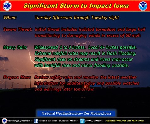
Severe storm outlook (NWS/Des Moines)
Severe storms are becoming more likely – especially late Tuesday afternoon through mid-evening with tornadoes, large hail and damaging winds all possible. In addition, a significant heavy rainfall event is expected and may result in localized flash flooding and significant rises on area streams and some rivers.
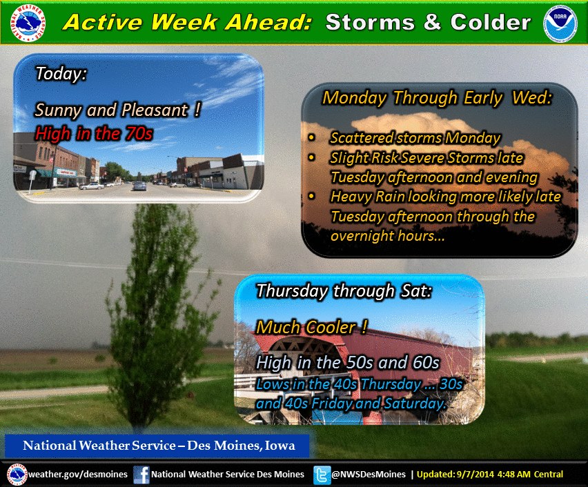
Much colder air will follow the storm by Thursday night. Early morning lows Friday and Saturday are forecast to dip into the 30s in some areas. Highs will only reach the 50s to lower 60s both Thursday and Friday.
AREA COUNTIES: SAC-CRAWFORD-CARROLL-AUDUBON-GUTHRIE-DALLAS-CASS-ADAIR-MADISON-ADAMS-UNION-TAYLOR-RINGGOLD-
531 AM CDT MON SEP 8 2014
TODAY AND TONIGHT….NON SEVERE THUNDERSTORMS WILL SPREAD ACROSS THE AREA TODAY THROUGH THE AFTERNOON. ANOTHER ROUND OF THUNDERSTORMS IS LIKELY DURING
THE EVENING AND OVERNIGHT TONIGHT. A FEW STORMS MAY BE SEVERE WITH LARGE HAIL AND WIND BEING THE MAIN THREATS.
TUESDAY AND WEDNESDAY….A SIGNIFICANT STORM WILL AFFECT THE AREA TUESDAY AFTERNOON THROUGH EARLY WEDNESDAY MORNING. A FEW MAINLY NON SEVERE THUNDERSTORMS WILL BE POSSIBLE TUESDAY MORNING THROUGH EARLY AFTERNOON.
THUNDERSTORMS ARE LIKELY LATE TUESDAY AFTERNOON AND TUESDAY NIGHT. SEVERE THUNDERSTORMS WITH HEAVY RAINFALL…DAMAGING WINDS…TORNADOES AND A LESSER THREAT FOR LARGE HAIL WILL BE POSSIBLE IN THE LATE AFTERNOON THROUGH MID EVENING. LATE IN THE EVENING OR TUESDAY NIGHT DAMAGING WINDS AND HEAVY RAINFALL WILL BE
THE MAIN THREATS ACROSS MUCH OF THE AREA. THERE IS A POTENTIAL FOR FLASH FLOODING DUE TO HIGH RAINFALL RATES AND SOME RIVERS OR STREAMS MAY REACH BANKFULL OR PRODUCE MINOR FLOODING.
SPOTTER INFORMATION STATEMENT…
SPOTTER ACTIVATION WILL LIKELY BE NEEDED TUESDAY AFTERNOON AND EVENING OVER PORTIONS OF THE OUTLOOK AREA.
AREA COUNTIES: MONONA-HARRISON-SHELBY-POTTAWATTAMIE-MILLS-MONTGOMERY-FREMONT-PAGE
TODAY AND TONIGHT…A FEW THUNDERSTORMS ARE EXPECTED IN NORTHEAST NEBRASKA AND MAYBE WEST CENTRAL IOWA THIS MORNING. A FEW OF THESE STORMS COULD CONTAIN HAIL AND WERE DRIVEN BY AN UPPER LEVEL DISTURBANCE AND ASSOCIATED LOW LEVEL JET.
ADDITIONAL THUNDERSTORMS COULD DEVELOP OR MOVE INTO THE REGION TONIGHT…MAINLY AFTER MIDNIGHT…AS ANOTHER DISTURBANCE APPROACHES. SEVERE WEATHER WITH THESE STORMS IS UNLIKELY.
TUESDAY AND WEDNESDAY…THUNDERSTORMS ARE EXPECTED TO BECOME MORE WIDESPREAD OVER THE AREA TUESDAY AND TUESDAY EVENING AS MOISTURE AND INSTABILITY INCREASES ACROSS THE PLAINS AND A DISTURBANCE SENDS A COLD FRONT
INTO NEBRASKA. SEVERE THUNDERSTORMS ARE POSSIBLE…MAINLY FROM LATE TUESDAY AFTERNOON THROUGH TUESDAY EVENING…WITH DAMAGING WINDS AND LARGE HAIL PRIMARY HAZARDS ALONG WITH LOCALLY HEAVY RAIN. IN ADDITION…A SMALL WINDOW COULD EXIST FROM LATE AFTERNOON THROUGH MID EVENING FOR TORNADOES IF CONVECTIVE DEBRIS DOES NOT BECOME TOO WIDESPREAD ALLOWING MORE ISOLATED STORMS ALONG A POSSIBLE WARM FRONT IN SOUTHEAST OR EAST CENTRAL NEBRASKA AND
SOUTHWEST IOWA.
The Freese-Notis weather forecast for the KJAN listening area and weather info. for Atlantic.

Podcast: Play in new window | Download (1.0MB)
Subscribe: RSS
Early This Morning – Mostly clear. South wind 5 to 10 mph.
Today – Mostly sunny. A slight chance of thunderstorms in the late morning and early afternoon. A chance of thunderstorms late in the afternoon. High in the upper 70s. South wind 5 to 15 mph. Chance of thunderstorms 40 percent.
Tonight – Mostly cloudy. A slight chance of thunderstorms in the evening…then a chance of thunderstorms overnight. Warmer. Low in the mid 60s. South wind 5 to 15 mph. Chance of thunderstorms 40 percent.
Tuesday – Mostly cloudy. Scattered thunderstorms in the morning… Then thunderstorms likely early in the afternoon. Thunderstorms late in the afternoon. High in the lower 80s. South wind 5 to 15 mph. Chance of thunderstorms 80 percent.
Tuesday Night – Thunderstorms. Some thunderstorms may produce heavy rainfall through midnight. Low in the mid 60s. Southeast wind 10 to 15 mph shifting to the southwest after midnight. Gusts up to 25 mph. Chance of thunderstorms near 100 percent.
Wednesday – Cloudy. A 40 percent chance of showers and drizzle in the morning. Cooler. High in the upper 60s. Northwest wind 10 to 15 mph with gusts to around 25 mph.
Wednesday Night – Mostly cloudy. Cooler. Low in the upper 40s.
Thursday – Mostly cloudy with a 20 percent chance of light rain. High around 60.
(click on the image to enlarge)
Officials with the National Weather Service in Des Moines say the weather will turn very active next week. After a pleasant day today (Sunday), a few storms return on Monday and Monday night. A greater threat for severe weather is expected Tuesday afternoon and evening. Along with that, thunderstorms with heavy rainfall are becoming more likely Tuesday evening and overnight into early Wednesday. Very cool Canadian air arrives Thursday evening and will last through Saturday. Lows will fall into the 30s and 40s at times!
Early This Morning Clear. Patchy fog. West wind near 5 mph.
Today -Sunny. Patchy fog through mid morning. High in the mid 70s. South wind near 10 mph.
Tonight – Mostly clear. Low in the mid 50s. South wind 5 to 10 mph.
Monday – Partly sunny with a slight chance of showers and isolated thunderstorms. High in the upper 70s. South wind 5 to 15 mph. Chance of precipitation 20 percent.
Monday Night – Mostly cloudy with a 50 percent chance of thunderstorms. Low in the mid 60s. South wind 5 to 15 mph.
Tuesday – Mostly cloudy. A chance of thunderstorms in the morning… Then thunderstorms likely in the afternoon. High in the upper 70s. South wind 5 to 15 mph. Chance of thunderstorms 60 percent.
Tuesday Night – Thunderstorms through midnight…then showers and scattered thunderstorms after midnight. Low in the mid 60s. Chance of precipitation 90 percent.
Wednesday – Cloudy. A chance of showers in the morning…then a slight chance of showers in the afternoon. High in the lower 70s. Chance of showers 40 percent.


