
345 AM CDT SAT SEP 13 2014/ NWS – Des Moines
…FROST ADVISORY IN EFFECT UNTIL 8 AM CDT THIS MORNING…
EARLY THIS MORNING…CLEAR…COLDER. PATCHY FROST. WEST WIND NEAR 5 MPH.
TODAY...SUNNY. PATCHY FROST THROUGH MID MORNING. HIGH IN THE UPPER 50S. SOUTHWEST WIND NEAR 5 MPH SHIFTING TO THE SOUTH 5 TO 15 MPH IN THE AFTERNOON.
TONIGHT…MOSTLY CLEAR. LOW IN THE LOWER 40S. SOUTH WIND 5 TO 10 MPH.
SUNDAY…MOSTLY SUNNY. HIGH IN THE UPPER 60S. SOUTH WIND 5 TO 10 MPH.
SUNDAY NIGHT...MOSTLY CLOUDY. A CHANCE OF SHOWERS AND ISOLATED THUNDERSTORMS THROUGH MIDNIGHT…THEN SHOWERS LIKELY AND ISOLATED THUNDERSTORMS AFTER MIDNIGHT. WARMER. LOW IN THE LOWER 50S. SOUTHEAST WIND AROUND 5 MPH. CHANCE OF PRECIPITATION 70 PERCENT.
MONDAY…MOSTLY CLOUDY WITH A 40 PERCENT CHANCE OF SHOWERS IN THE MORNING…THEN MOSTLY SUNNY IN THE AFTERNOON. HIGH IN THE MID 60S. NORTH WIND 5 TO 10 MPH.
MONDAY NIGHT AND TUESDAY…MOSTLY CLEAR. LOW AROUND 40. HIGH IN THE MID 60S.
A FROST ADVISORY is in effect through late this morning for the entire KJAN listening area. The ADVISORY runs through 8-a.m. for Cass, Adair, Adams, Audubon, Crawford, Carroll, Guthrie, Madison, Taylor, Union and Ringgold Counties….and until 9-a.m., for Monona, Harrison, Shelby, Pottawattamie, Mills, Montgomery, Fremont and Page Counties.
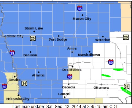
Areas in light blue are included in a FROST ADVISORY Saturday morning
Temperatures will remain in the middle 30’s until around 8-or 9-a.m., allowing for areas of frost to develop, especially in the low-lying regions. Sensitive outdoor vegetation could be damaged or killed by frost if left uncovered.
AREA COUNTIES….SAC-CRAWFORD-CARROLL-AUDUBON-GUTHRIE-DALLAS-CASS-ADAIR-MADISON-ADAMS-UNION-TAYLOR-RINGGOLD…
328 PM CDT FRI SEP 12 2014
…FROST ADVISORY IN EFFECT FROM 3 AM TO 8 AM CDT SATURDAY…
THE NATIONAL WEATHER SERVICE IN DES MOINES HAS ISSUED A FROST ADVISORY…WHICH IS IN EFFECT FROM 3 AM TO 8 AM CDT SATURDAY.
* TIMING…EARLY SATURDAY MORNING.
* TEMPERATURE…TEMPERATURES WILL FALL WITHIN A RANGE OF 32 TO 35 DEGREES BY DAYBREAK SATURDAY.
* IMPACTS…PLANTS AND TENDER VEGETATION MAY BE KILLED IF LEFT OUTSIDE UNCOVERED.
PRECAUTIONARY/PREPAREDNESS ACTIONS…
A FROST ADVISORY MEANS THAT FROST IS POSSIBLE. SENSITIVE OUTDOOR PLANTS MAY BE KILLED IF LEFT UNCOVERED.
Atlantic (@ KJAN), .28″; Massena, .45″.
Other reports….Shenandoah, .24″; Clarinda, .22″; 1.5 miles S. of Avoca, .4″; Oakland, .50″; Emerson, .44″; Henderson, .39″; Irwin, .3″; Audubon, .4″ ; Red Oak, .45″ ; Hamburg and Bedford, .3″ each.
The (podcast) Freese-Notis forecast and weather information (including precip/HI-LO temps) for Atlantic.

Podcast: Play in new window | Download (1.1MB)
Subscribe: RSS
401 AM CDT FRI SEP 12 2014
EARLY THIS MORNING…LIGHT RAIN LIKELY. NORTHEAST WIND 5 TO 10 MPH. CHANCE OF RAIN 70 PERCENT.
TODAY...CLOUDY. LIGHT RAIN IN THE MORNING…THEN A CHANCE OF LIGHT RAIN IN THE AFTERNOON. HIGH IN THE LOWER 50S. NORTH WIND 5 TO 10 MPH. CHANCE OF RAIN 90 PERCENT.
TONIGHT…MOSTLY CLOUDY IN THE EVENING THEN CLEARING. COLDER. PATCHY FROST EARLY IN THE MORNING. LOW IN THE MID 30S. WEST WIND NEAR 5 MPH.
SATURDAY…SUNNY. PATCHY FROST THROUGH MID MORNING. HIGH IN THE LOWER 60S. SOUTH WIND NEAR 10 MPH.
SATURDAY NIGHT...MOSTLY CLEAR. NOT AS COOL. LOW IN THE MID 40S. SOUTH WIND 5 TO 10 MPH.
SUNDAY…MOSTLY SUNNY. HIGH IN THE UPPER 60S. SOUTH WIND 5 TO 10 MPH.
SUNDAY NIGHT…CLOUDY. A SLIGHT CHANCE OF SHOWERS THROUGH MIDNIGHT…THEN A CHANCE OF SHOWERS AFTER MIDNIGHT. LOW IN THE MID 50S. CHANCE OF SHOWERS 50 PERCENT.
MONDAY…CLOUDY WITH A 20 PERCENT CHANCE OF SHOWERS. HIGH IN THE UPPER 60S.
The (podcast) Freese-Notis forecast and weather information (including precip/HI-LO temps) for Atlantic.
Podcast: Play in new window | Download (1,016.0KB)
Subscribe: RSS
THE NATIONAL WEATHER SERVICE IN DES MOINES HAS ISSUED A FLOOD WARNING FOR…MADISON COUNTY IN SOUTH CENTRAL IOWA…UNTIL 315 AM CDT THURSDAY
* AT 321 PM CDT…LOCAL LAW ENFORCEMENT REPORTED FLOODING IN NUMEROUS AREAS ACROSS THE COUNTY. THERE HAS BEEN LITTLE TO NO IMPROVEMENT THIS AFTERNOON.
* SOME LOCATIONS THAT WILL EXPERIENCE FLOODING INCLUDE…WEST DES MOINES…WINTERSET…EARLHAM…AVENUE OF THE SAINTS EVENT CENTER…ST. CHARLES…TRURO…PATTERSON…EAST PERU…MACKSBURG…BEVINGTON…BADGER CREEK STATE PARK AND WINTERSET-MADISON COUNTY AIRPORT.
PRECAUTIONARY/PREPAREDNESS ACTIONS…
A FLOOD WARNING MEANS THAT FLOODING IS IMMINENT OR HAS BEEN REPORTED. STREAM RISES WILL BE SLOW AND FLASH FLOODING IS NOT EXPECTED. HOWEVER…ALL INTERESTED PARTIES SHOULD TAKE NECESSARY PRECAUTIONS IMMEDIATELY.
DO NOT DRIVE YOUR VEHICLE INTO AREAS WHERE THE WATER COVERS THE ROADWAY. THE WATER DEPTH MAY BE TOO GREAT TO ALLOW YOUR CAR TO CROSS SAFELY. MOVE TO HIGHER GROUND.
Rainfall in Atlantic, at the KJAN studios through 3:40-a.m. today (9/9/14), amounted to 3.12″ since the rain began to fall at around 12:30-p.m., Tuesday. Elsewhere in town, a resident near 7th & Birch reported 7.10″ over the past 24-hours, while 3.8″ was reported at a business on Chestnut Street.
Other reported rain totals include (as of early this morning): 6.10″ in Afton (Union County); 4.4″ in Villisca; 4.25″ in Adair & Greenfield; 4.22″ 3 miles e/se of Anita; 4.2″ in Massena (Ardell McCunn); 4.18″ in Winterset; 2 miles n/ne of Lewis, 4.16″; 2.5″ 3 miles west of Oakland; ; 3.30″ 3 miles w. of Pacific Junction; 3.34″ at Earlham; Fontanelle, 2.4″‘ 2.1″ just south of Guthrie Center; 3.15″ in Corning; 2.20″ 3 miles s. of Creston; 2.02″ in Shenandoah; 3.30″ near Hamburg; 2.25″ in Emerson; 1.91 in Audubon; 1.7″ in Bedford; 1.6″ in Coon Rapids.
Other events:
9-p.m. Tues. – Numerous tree limbs down in and near Griswold, some blocking roads. Unspecified damage reported by Cass Co. Sheriff’s Deputy at or near the Conklin Fish Farm.
2″ diameter hail (slightly large than golf-ball size) 5-mile e/se of Corning at around 4:40-p.m. Tues.
2″ dia. hail in Lenox reported at 5:05-p.m. Tues.
1.75″ (Golf ball size) hail reported 7-miles s/se of Prescott, in Adams Co., at around 5:10-p.m. Tues.
1″ hail reported 2 miles s. of Lenox at around 5:20-p.m. Tues.
7:47-p.m. water reported over some secondary roads in Union County, near Kent.


