
**DENSE FOG ADVISORY until 9-a.m.**
Today Showers and thunderstorms. Areas of fog before 9am. High near 68. Northeast wind 5 to 11 mph. Chance of precipitation is 80%. New rainfall amounts between a quarter and half of an inch possible.
Tonight A chance of showers and thunderstorms before 10pm, then a slight chance of showers between 10pm and 1am. Partly cloudy, with a low around 44. North northwest wind 8 to 15 mph, with gusts as high as 21 mph. Chance of precipitation is 30%. New rainfall amounts of less than a tenth of an inch, except higher amounts possible in thunderstorms.
Friday Mostly sunny, with a high near 53. Windy, with a west northwest wind 16 to 21 mph increasing to 23 to 28 mph in the afternoon. Winds could gust as high as 37 mph.
Friday Night Mostly clear, with a low around 34. Breezy, with a west northwest wind 9 to 18 mph, with gusts as high as 26 mph.
Saturday Mostly sunny, with a high near 55. West northwest wind 10 to 15 mph, with gusts as high as 21 mph.
Saturday Night Partly cloudy, with a low around 41.
Sunday Mostly sunny, with a high near 64.
…DENSE FOG ADVISORY IN EFFECT UNTIL 9 AM CDT THURSDAY…
THE NATIONAL WEATHER SERVICE IN DES MOINES HAS ISSUED A DENSE FOG
ADVISORY…WHICH IS IN EFFECT UNTIL 9 AM CDT THURSDAY, FOR CASS, ADAIR, ADAMS, AUDUBON, CARROLL, GUTHRIE, DALLAS, MADISON, UNION AND RINGGOLD COUNTIES IN THE KJAN LISTENING AREA.
* VISIBILITY…VISIBILITY WILL FALL BELOW A QUARTER OF A MILE IN MANY AREAS…AND TO NEAR ZERO AT TIMES.
* IMPACTS…DRIVING WILL BECOME HAZARDOUS DUE TO LOW AND CHANGING VISIBILITIES. PLEASE DRIVE SLOWLY AND ALLOW EXTRA TIME FOR TRAVEL.
PRECAUTIONARY/PREPAREDNESS ACTIONS…
A DENSE FOG ADVISORY MEANS VISIBILITIES WILL FREQUENTLY BE REDUCED TO LESS THAN ONE QUARTER MILE. IF DRIVING…SLOW DOWN… USE YOUR HEADLIGHTS…AND LEAVE PLENTY OF DISTANCE AHEAD OF YOU.
The National Weather Service in Omaha has issued a Flood Warning for the East Nishnabotna River at Red Oak, until Friday morning. The river is projected to rise to 19.2 feet however, additional rain and severe weather could increase this amount over the next day or two.
Should additional warnings and flooding concern occur, information will be posted immediately. At 19.2 feet, very minor lowland flooding will begin.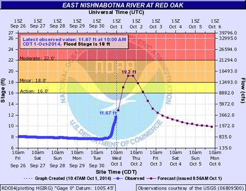
Here’s a look back at September’s weather, here in Atlantic: Rainfall for the month amounted to 6.44-inches, which was 2.63″ above the normal of 3.81.; The average High for the month was 74 degrees, which was just 2.4 degrees less than normal. The hottest day was on Sept. 4th, when we reached 92 degrees.
The average monthly Low was 49.4 degrees, which was slightly less than 2 degrees below the normal of 51.1. The coolest morning of the month was on Sept. 12th, when the thermometer dipped to 32 degrees.
(Information compiled at KJAN, the official National Weather Service reporting site for Atlantic)
(updated 9:20-a.m.)
24-hour rainfall in Atlantic at the KJAN studios (the Official National Weather Service site for Atlantic) was 2.08″ as of 7-a.m., Wednesday (10/1) . At the Atlantic Airport, the Automated Weather Observation System (AWOS) measured 2.26″. Seven-miles n/ne of Atlantic, a spotter observed 2.06″ of rain in their gauge. KJAN’s Lavon Eblen reported 2.5″ of rain at her home north of Atlantic.
If you have a rainfall total to report, e-mail kjannews@metc.net. Please include your location or proximity to the nearest town, the amount of rain that has fallen, and the time your measurement was taken. Feel free to update the total as the day wears on. Thank You!
Other 24-hour rainfall reports we’ve received this morning:
3.90″ 3 miles west of Pacific Junction in Mills County; 3.40″ 3 miles east of Manning; 3.10 in Anita near the golf course (reported by Rosalie Kopp); 3.10″ in Shenandoah (updated total); 3.00″ in Audubon (also, 3.10″ n of the Audubon Airport as of 7:30-a.m.); 2.80″ in Oakland and in Marne; 2.62″ west of Bagley, in Guthrie County; 2.60″ 1.5 miles s. of Avoca; 2.32″ 1 mi. S. of Guthrie Center in Guthrie County; 2.28″ 4 miles e/se of Carroll; 2.20″ south of Bedford (2.4″ reported N of Bedford); 2.18″ in Massena (Ardelle McCunn); 2.04″ 3 miles NE of Yale in Guthrie County; 1.92″ in Harlan; 1.85″ in Emerson; 1.81″ 4-miles north of New Market, in Taylor County; 1.74″ in Clarinda; 1.62″ at Jefferson (as of 5:15-a.m.) – from an NWS Cooperative Observer; 1.61″ northeast of Creston; 1.58″ 2 miles NE of Denison.
Despite the recent warm temperatures across Iowa, the month of September was slightly cooler than normal, according to state climatologist Harry Hillaker. The month was highlighted by freezing conditions on September 13. That marked the earliest freeze in the state since 1976. Hillaker says the temperature hit 31-degrees in Mason City, Estherville, Sheldon, Elkader, and Sioux Center. He notes it “wasn’t cold enough, long enough” to do much widespread damage to crops.
The hottest temperature during the month was recorded on September 4. “The highest reading was 94-degrees, which happened in Glenwood, Shenandoah, Sidney, and Donnellson,” Hillaker says. Fall officially arrived on September 22 and Hillaker says the temperature failed to reach triple-digits anywhere in Iowa the entire summer. “In fact, we have a few places in northeastern and far northern Iowa that (haven’t) reached the 90s this year,” Hillaker says. The wetter than normal weather this year continued through the month of September.
It was especially rainy over the first half of the month in parts of southern Iowa. Areas of Warren County received up to 9 inches of rain over the month. “On the other extreme, Estherville was the dry spot in the state with just 1.2 inches of rain during the month,” Hillaker says. The statewide average rainfall total in September was 4.5 inches, about one-inch above normal for the month, according to Hillaker. The statewide average temperature for the month was 62.2 degrees, about one-degree cooler than normal.
(Radio Iowa)
Today Periods of showers and possibly a thunderstorm before 11am, then scattered showers and thunderstorms, mainly between 11am and 1pm. High near 75. South wind 8 to 10 mph. Chance of precipitation is 80%. New rainfall amounts between a quarter and half of an inch possible.
Tonight A chance of showers and thunderstorms, then showers likely and possibly a thunderstorm after 4am. Mostly cloudy, with a low around 58. South southeast wind around 5 mph becoming calm. Chance of precipitation is 60%. New rainfall amounts of less than a tenth of an inch, except higher amounts possible in thunderstorms.
Thursday Showers and thunderstorms before 1pm, then showers likely and possibly a thunderstorm between 1pm and 4pm, then a chance of showers after 4pm. High near 68. North northeast wind 6 to 10 mph. Chance of precipitation is 80%. New rainfall amounts between a half and three quarters of an inch possible.
Thursday Night A 30 percent chance of showers, mainly before 7pm. Cloudy during the early evening, then gradual clearing, with a low around 44. Breezy, with a west northwest wind 10 to 16 mph, with gusts as high as 23 mph. New precipitation amounts of less than a tenth of an inch possible.
Friday Mostly sunny, with a high near 54. Windy, with a west northwest wind 16 to 26 mph, with gusts as high as 40 mph.
Friday Night Mostly clear, with a low around 34. Windy.
Saturday Mostly sunny, with a high near 56.
The (podcast) Freese-Notis weather forecast for the KJAN listening area and weather info. for Atlantic.

Podcast: Play in new window | Download (1,012.3KB)
Subscribe: RSS
AREA COUNTIES: MONONA-HARRISON-SHELBY-POTTAWATTAMIE-MILLS-MONTGOMERY-FREMONT-PAGE-
TODAY AND TONIGHT:
SCATTERED THUNDERSTORMS WILL SPREAD INTO THE AREA THIS MORNING AND
MAY CONTINUE INTO TONIGHT AS A FRONTAL BOUNDARY STALLS OVER THE
AREA AND A STRONG UPPER LEVEL SYSTEM MOVES FROM WESTERN NEBRASKA
TO NORTH DAKOTA. ISOLATED STORMS MAY PRODUCE LARGE HAIL THIS
AFTERNOON BUT THE BETTER CHANCE OF SEVERE STORMS IS EXPECTED TO
BE OVER PARTS OF NORTHEAST NEBRASKA.
WEDNESDAY THROUGH MONDAY:
MORE THUNDERSTORMS ARE EXPECTED TO PREVAIL OVER THE AREA
WEDNESDAY INTO THURSDAY AS ADDITIONAL UPPER LEVEL SYSTEMS AND A
COLD FRONT MOVE ACROSS THE AREA. SOME STORMS MAY BE SEVERE IN
PARTS OF EASTERN NEBRASKA AND SOUTHWEST IOWA WITH LARGE HAIL
THE PRIMARY HAZARD.
SPOTTER INFORMATION STATEMENT…
SPOTTER ACTIVATION IS NOT EXPECTED AT THIS TIME TODAY OR TONIGHT.
AREA COUNTIES: SAC-CRAWFORD-CARROLL-AUDUBON-GUTHRIE-DALLAS-CASS-ADAIR-MADISON-ADAMS-UNION-TAYLOR-RINGGOLD
533 AM CDT TUE SEP 30 2014
TODAY AND TONIGHT: SCATTERED NON SEVERE THUNDERSTORMS WILL BE ON THE INCREASE ACROSS THE WEST THIS MORNING AND OVER THE ENTIRE REGION TONIGHT.
WEDNESDAY THROUGH MONDAY: THUNDERSTORM CHANCES ARE FORECAST TO PERSIST THROUGH THURSDAY. HOWEVER…THE OVERALL PROBABILITY OF SEVERE WEATHER REMAINS LOW AT THIS TIME. IF SEVERE WEATHER DOES OCCUR…THE PERIOD OF MOST
CONCERN WOULD BE WEDNESDAY AFTERNOON AND EVENING OVER THE FAR
SOUTHWEST PORTION OF THE OUTLOOK AREA WHERE THERE IS A SLIGHT RISK
OF SEVERE THUNDERSTORMS.
SPOTTER INFORMATION STATEMENT…
SPOTTER ACTIVATION IS NOT ANTICIPATED AT THIS TIME.


