
TORNADO WATCH NUMBER 156; NWS STORM PREDICTION CENTER NORMAN OK 1045 AM CDT SUN MAY 10 2015
IOWA COUNTIES INCLUDE: ADAIR AUDUBON BUENA VISTA CALHOUN CARROLL CASS CHEROKEE CLAY CRAWFORD DICKINSON EMMET GREENE
GUTHRIE HARRISON IDA LYON MONONA O`BRIEN OSCEOLA PALO ALTO PLYMOUTH POCAHONTAS POTTAWATTAMIE SAC SHELBY SIOUX WOODBURY
THE NWS STORM PREDICTION CENTER HAS ISSUED A TORNADO WATCH FOR PORTIONS OF WESTERN IOWA SOUTHWEST MINNESOTA EASTERN NEBRASKA SOUTHEASTERN SOUTH DAKOTA EFFECTIVE THIS SUNDAY MORNING AND EVENING FROM 1045 AM UNTIL 900 PM CDT.
* PRIMARY THREATS INCLUDE…
A FEW TORNADOES LIKELY; SCATTERED LARGE HAIL EVENTS TO 1.5 INCHES IN DIAMETER LIKELY; ISOLATED DAMAGING WIND GUSTS TO 70 MPH POSSIBLE.
SCATTERED SUPERCELLS AND SHORT LINES OF SUSTAINED STORMS WITH A THREAT FOR HAIL…LOCALLY DAMAGING WIND…AND A FEW TORNADOES EXPECTED OVER WATCH AREA THROUGH EARLY TONIGHT.
THE TORNADO WATCH AREA IS APPROXIMATELY ALONG AND 80 STATUTE MILES EAST AND WEST OF A LINE FROM 10 MILES NORTH NORTHWEST OF BROOKINGS SOUTH DAKOTA TO 5 MILES SOUTH SOUTHWEST OF OMAHA NEBRASKA.
PRECAUTIONARY/PREPAREDNESS ACTIONS…
REMEMBER…A TORNADO WATCH MEANS CONDITIONS ARE FAVORABLE FOR TORNADOES AND SEVERE THUNDERSTORMS IN AND CLOSE TO THE WATCH AREA. PERSONS IN THESE AREAS SHOULD BE ON THE LOOKOUT FOR THREATENING WEATHER CONDITIONS AND LISTEN FOR LATER STATEMENTS AND POSSIBLE WARNINGS.
516 AM CDT SUN MAY 10 2015
CRAWFORD-CARROLL-AUDUBON-GUTHRIE-DALLAS-CASS-ADAIR-MADISON-ADAMS-UNION-TAYLOR-RINGGOLD COUNTIES….
SEVERE STORMS ARE EXPECTED ACROSS THE AREA TODAY ESPECIALLY THIS AFTERNOON AND EARLY EVENING. HAIL UP TO 2 INCHES IN DIAMETER…DAMAGING WINDS TO 70 MPH AND TORNADOES ARE ALL
POSSIBLE. A STRONG AND LONG TRACKED TORNADO MAY OCCUR.
MONDAY THROUGH SATURDAY: CHANCES FOR THUNDERSTORMS RETURN FOR WEDNESDAY NIGHT THROUGH SATURDAY. A FEW SEVERE STORMS MAY OCCUR THROUGH THE PERIOD.
SPOTTER INFORMATION STATEMENT: SPOTTER ACTIVATION MAY BE REQUIRED BETWEEN 1 PM AND 7 PM TODAY. SEVERE WEATHER REPORTS ARE HIGHLY ENCOURAGED.
441 AM CDT SUN MAY 10 2015
SKIES ACROSS IOWA WERE OVERCAST EARLY SUNDAY MORNING. TEMPERATURES HAD COOLED INTO THE UPPER 50S AND LOW 60S. WINDS WERE FROM THE EAST AT 10 TO 15 MPH WITH GUSTS IN SOME LOCATIONS UP TO 25 MPH. A BAND OF SHOWERS AND THUNDERSTORMS WAS BEGINNING TO LIFT INTO WESTERN IOWA IN THE EARLY MORNING HOURS.
A SURFACE LOW PRESSURE SYSTEM WILL LIFT NORTHEAST INTO EASTERN SOUTH DAKOTA THROUGHOUT THE DAY TODAY. THIS LOW PRESSURE SYSTEM WILL BRING CHANCES FOR SHOWERS AND THUNDERSTORMS TO THE REGION SUNDAY. PRECIPITATION CHANCES WILL GENERALLY COME IN THE MORNING…AND AGAIN IN THE AFTERNOON AND OVERNIGHT HOURS.
THUNDERSTORMS MAY BE SEVERE…ESPECIALLY IN THE AFTERNOON…WITH LARGE HAIL…DAMAGING WINDS AND TORNADOES ALL POSSIBLE…ESPECIALLY IN IOWA AND WESTERN NEBRASKA AND SOUTH DAKOTA. AS THE SYSTEM PUSHES EAST…MUCH COLDER AND DRIER AIR WILL PUSH IN BEHIND FOR EARLY IN THE WORK WEEK. TEMPERATURES WILL BE BELOW NORMAL…WITH HIGHS IN THE 50S AND 60S TUESDAY…AND OVERNIGHT LOWS IN THE UPPER 30S AND 40S.
A WARMING TREND RETURNS WEDNESDAY.THROUGH THE END OF THE WEEK…ALONG WITH ADDITIONAL CHANCES FOR SHOWERS AND THUNDERSTORMS.
MONONA-HARRISON-SHELBY-POTTAWATTAMIE-MILLS-MONTGOMERY-FREMONT-PAGE COUNTIES. 418 AM CDT SUN MAY 10 2015
THIS HAZARDOUS WEATHER OUTLOOK IS FOR PORTIONS OF SOUTH WEST IOWA,WEST CENTRAL IOWA, EAST CENTRAL NEBRASKA, NORTHEAST NEBRASKA AND SOUTHEAST NEBRASKA.
TODAY AND TONIGHT: SEVERE THUNDERSTORMS WITH THE POSSIBILITY OF A FEW TORNADOES. LARGE HAIL, AND HIGH WINDS WILL BE POSSIBLE THIS AFTERNOON AND INTO THE EARLY EVENING HOURS. THE GREATEST CHANCE FOR SEVERE STORMS APPEARS TO BE IN THE NORTHEAST CORNER OF NEBRASKA AND WEST CENTRAL IOWA, OR FROM THE HARTINGTON AND WAYNE AREAS TO HARLAN.
THERE IS ALSO A CHANCE FOR SEVERE STORMS FROM NORFOLK TO THE OMAHA METRO AREA AND INTO SOUTHWEST IOWA. SCATTERED SHOWERS AND THUNDERSTORMS MAY BE MOVING THROUGH THE REGION DURING THE MORNING HOURS…BUT SEVERE STORMS ARE NOT EXPECTED TO DEVELOP UNTIL THE EARLY TO MID AFTERNOON…WITH PEAK TIMING FOR SEVERE WEATHER DURING THE LATE AFTERNOON HOURS. THE STORMS SHOULD MOVE OUT OF THE AREA BY LATE EVENING.
MONDAY THROUGH SATURDAY: INTERMITTENT CHANCES FOR THUNDERSTORMS RETURN FROM WEDNESDAY NIGHT THROUGH SATURDAY.
SPOTTER INFORMATION STATEMENT: SPOTTER ACTIVATION WILL LIKELY BE NEEDED THIS AFTERNOON AND POSSIBLY INTO THE EARLY EVENING HOURS.
452 AM CDT SUN MAY 10 2015
EARLY THIS MORNING…CLOUDY WITH A 50 PERCENT CHANCE OF THUNDERSTORMS. WARMER. EAST WIND 10 TO 15 MPH.
TODAY…MOSTLY CLOUDY. SCATTERED SHOWERS AND ISOLATED THUNDERSTORMS THROUGH MID MORNING…THEN SCATTERED THUNDERSTORMS IN THE LATE MORNING AND EARLY AFTERNOON. NUMEROUS THUNDERSTORMS LATE IN THE AFTERNOON. SOME THUNDERSTORMS MAY BE SEVERE IN THE AFTERNOON. HIGH IN THE MID 70S. SOUTHEAST WIND 10 TO 15 MPH WITH GUSTS TO AROUND 25 MPH. CHANCE OF PRECIPITATION 60 PERCENT.
TONIGHT…MOSTLY CLOUDY WITH A CHANCE OF THUNDERSTORMS IN THE EVENING…THEN PARTLY CLOUDY WITH A SLIGHT CHANCE OF THUNDERSTORMS BEFORE MIDNIGHT. PARTLY CLOUDY AFTER MIDNIGHT. COOLER. SOME THUNDERSTORMS MAY BE SEVERE IN THE EVENING. LOW IN THE MID 40S. SOUTHWEST WIND 10 TO 15 MPH WITH GUSTS TO AROUND 25 MPH. CHANCE OF THUNDERSTORMS 50 PERCENT.
MONDAY…PARTLY SUNNY. BREEZY…COOLER. HIGH IN THE UPPER 50S. WEST WIND 10 TO 15 MPH INCREASING TO 20 TO 25 MPH IN THE AFTERNOON.
TUESDAY…SUNNY. HIGH IN THE LOWER 60S. NORTHWEST WIND 10 TO 15 MPH.
WEDNESDAY…MOSTLY SUNNY. HIGH IN THE UPPER 60S.
DES MOINES, Iowa (AP) — Updated National Weather Service forecasts for Iowa and Nebraska indicate rain for Iowa with possibly strong storms developing on Sunday and a blast of a winter-like snowstorm for Western Nebraska.
Iowa’s rain chances increase into Saturday evening and there is potential for early Sunday morning severe weather continuing into Mother’s Day afternoon with areas of concern along the Iowa/Minnesota state line and in Western Iowa.
Southwest and west-central portions of Nebraska are areas of concern beginning with thunderstorms. Severe storms also could develop along the Nebraska/Iowa state line Saturday night.
Sunday brings possible isolated tornadoes from extreme eastern Nebraska into southwest Iowa Sunday afternoon. A winter weather advisory is issued for Sheridan County on northwest Nebraska, which could get up to 5 inches of snow Saturday night continuing into Sunday.
MONONA-HARRISON-SHELBY-POTTAWATTAMIE-MILLS-MONTGOMERY-FREMONT-PAGE COUNTIES….1217 PM CDT SAT MAY 9 2015
THIS AFTERNOON AND TONIGHT: ISOLATED THUNDERSTORMS MAY APPROACH THE SOUTHEAST NEBRASKA BORDER FROM KANSAS LATE THIS AFTERNOON BUT MORE WIDESPREAD ACTIVITY IS NOT EXPECTED UNTIL THIS EVENING WITH STORMS SPREADING NORTH DURING THE NIGHT. THERE WILL BE A MARGINAL RISK FOR SEVERE WEATHER ACROSS SOUTHEAST NEBRASKA AND SOUTHWEST IOWA THIS EVENING WITH LARGE HAIL AND DAMAGING WINDS THE PRIMARY HAZARDS. THE BETTER CHANCE OF WIDESPREAD HEAVY RAIN IS EXPECTED TO OCCUR WEST OF EASTERN NEBRASKA TONIGHT FROM CENTRAL INTO WESTERN NEBRASKA, ALTHOUGH LOCALLY HEAVY RAIN IS POSSIBLE WITH STRONGER STORMS.
SUNDAY THROUGH FRIDAY: THUNDERSTORMS WILL BE POSSIBLE ON SUNDAY AND SUNDAY NIGHT AND OVER THE OUTLOOK AREA. SOME STORMS MAY BE SEVERE SUNDAY AFTERNOON INTO EARLY SUNDAY EVENING IN EASTERN NEBRASKA AND SOUTHWEST IOWA. ISOLATED TORNADOES ARE POSSIBLE FROM EXTREME EASTERN NEBRASKA INTO SOUTHWEST IOWA LATE SUNDAY AFTERNOON BUT LARGE HAIL AND DAMAGING WINDS WILL BE THE PRIMARY HAZARDS.
THE CHANCE FOR THUNDERSTORMS THEN RETURNS WEDNESDAY THROUGH SATURDAY.
SPOTTER INFORMATION STATEMENT…
STORM SPOTTER ACTIVATION IS NOT ANTICIPATED AT THIS TIME FOR THIS AFTERNOON OR TONIGHT.

Podcast: Play in new window | Download (851.0KB)
Subscribe: RSS
956 AM CDT FRI MAY 8 2015
…The Flood Warning is cancelled for the following river…
Missouri River at Plattsmouth affecting Mills County (IA) and Cass County (NE).
…The Flood Warning continues for the following river…
Missouri River At Nebraska City affecting Fremont County (IA) and Otoe County (NE).
Mother Nature may be very busy on Mother’s Day. After a full week of stormy weather, forecasters say Iowans see a brief break from the clouds today (Friday), while the rains will return tomorrow. Meteorologist Kurt Kotenberg, at the National Weather Service, says it appears likely much of the state may see severe weather on Sunday.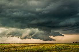
“It will probably start to get potentially bad early afternoon especially through the early evening,” Kotenberg says. “One of the things we’ll be working on today is to narrow it down to a more specific area. The southern part of the state has a little better chance than northern Iowa for severe weather, but we’re looking at a statewide threat, as of right now.”
While many Iowans may be traveling this weekend to celebrate the holiday, they may need to keep an umbrella handy, while some Iowans may need to retreat to the basement. “We could be looking at all modes of severe weather here in Iowa,” Kotenberg says. “We could see some hail, some damaging winds and maybe even a few tornadoes across the state. Stay tuned to the forecast the next couple of days as we try to pin it down a little more but it looks like it could be a pretty widespread severe weather threat for Sunday.”
Parts of Nebraska had tornadoes and severe flooding this week, while that state’s weekend forecast calls for up to eight inches of snow in the higher elevations of the Panhandle. “It looks like we’ll get to miss out on the cold weather here in Iowa,” Kotenberg says. “It’ll be cooler, certainly. We’ll probably see temperatures drop down to the 40s and high temperatures in the 60s, maybe even the 50s, but no snow in the forecast here in Iowa. It’ll be cooler, but snow-free.”
The skies may start to clear on Monday, as the forecast calls for a return to calmer, more seasonable weather.
(Radio Iowa)


