
The Freese-Notis (podcast) weather forecast for Atlantic & the KJAN listening area, and weather information for Atlantic.

Podcast: Play in new window | Download (1.0MB)
Subscribe: RSS
FLOOD WARNING
NATIONAL WEATHER SERVICE OMAHA/VALLEY NEBRASKA
251 AM CDT TUE JUN 16 2015
The National Weather Service in Omaha has issued a Flood Warning for
The West Nishnabotna River Near Riverton from Monday afternoon to late tonight…or until the warning is cancelled.
* At 2:15 AM Tuesday the stage was 24.2 feet…or 2.7 feet above flood stage.
* Flood stage is 21.5 feet.
* Minor flooding is forecast to continue.
* Forecast…the river will continue falling to below flood stage
late this afternoon.
* Impact…at 24.0 feet…The river is at bankfull and floodwaters
will begin to spread throughout the floodplain.
The National Weather Service in Omaha has issued a Flood Warning for
The East Nishnabotna River At Riverton.
* until Wednesday afternoon…or until the warning is cancelled.
* At 1:45 AM Tuesday the stage was 23.7 feet…or 0.2 feet above flood stage.
* Flood stage is 23.5 feet.
* Minor flooding is forecast to continue.
* Forecast…the river will slowly rise to near 24 feet at early
afternoon…then fall below flood stage this evening.
* Impact…at 23.5 feet…Lowland flooding begins.
…The Flood Warning continues for the following river…
East Nishnabotna River At Red Oak affecting Montgomery County.
PRECAUTIONARY/PREPAREDNESS ACTIONS…
Do not drive cars through areas where water covers the road. The
water depth may be too great to allow your vehicle to pass safely.
Turn around…don`t drown!
* At 10:30 PM Monday the stage was 20.1 feet…or 2.1 feet above flood stage.
* Flood stage is 18.0 feet.
* Minor flooding is occurring and Minor flooding is forecast.
* Forecast…The river will continue rising to near 20.3 feet before falling below flood stage early this afternoon.
* Impact…at 20.0 feet…Lowland flooding begins along the west bank.
Early This Morning: Mostly clear. Patchy fog. Northeast wind 5 to 10 mph.
Today: Sunny. Patchy fog through mid morning. High around 80. East wind 5 to 10 mph.
Tonight: Partly cloudy in the evening then becoming mostly cloudy. Low in the mid 60s. Southeast wind 5 to 10 mph.
Wednesday: Partly sunny. A 20 percent chance of thunderstorms in the late morning and afternoon. High in the lower 80s. South wind 5 to 10 mph.
Wednesday Night: Mostly cloudy with a 30 percent chance of thunderstorms. Low in the mid 60s. Southwest wind near 10 mph shifting to the northwest after midnight.
Thursday: Mostly cloudy in the morning then becoming mostly sunny. A 20 percent chance of thunderstorms. High in the lower 80s. Northeast wind 5 to 10 mph.
Thursday Night: Mostly cloudy with a 20 percent chance of thunderstorms. Low in the mid 60s.
Friday: Partly sunny with a 20 percent chance of thunderstorms. High in the lower 80s.
The Cass County Emergency Management Agency is continuing to monitor both the Troublesome Creek and East Nishnabotna Rivers, in Atlantic.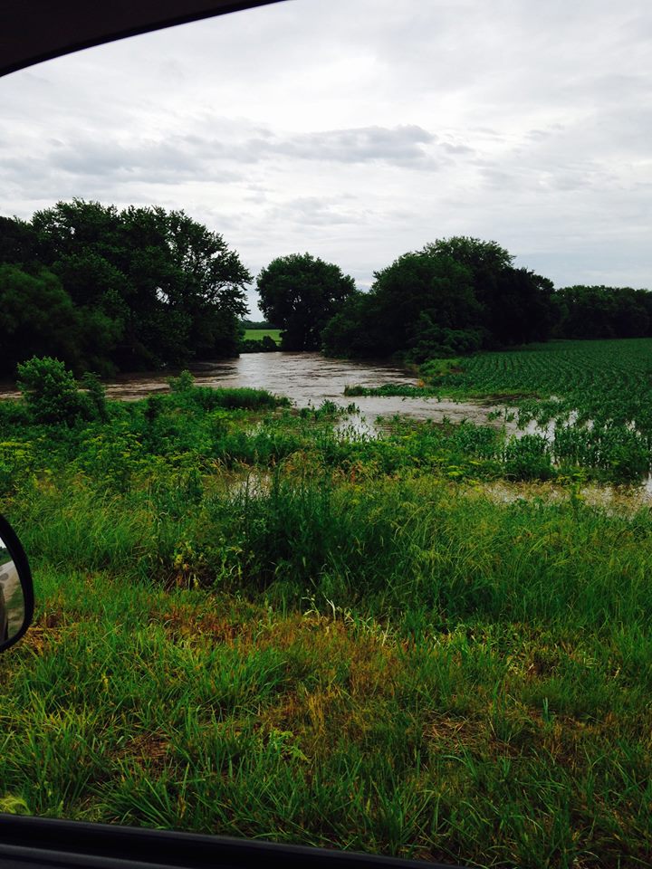 Troublesome was bank full and out of its banks to the south just east of the Olive Street bridge as of 11-a.m. At 10-a.m., the river was at 14.57-feet. Flood stage is 19-feet. The river is expected to crest at 15.5-feet, but Emergency Management Coordinator Mike Kennon said that depends on how much more rain we get locally and upstream.
No flood warnings have been issued for Cass County at this time, however a Flood Warning is in effect for the East Nishnabotna River at Red Oak, until early Tuesday morning.
The following are 24-hour (ending at 7-a.m. Mon., 6/15) rainfall amounts provided to and relayed by, the National Weather Service.
FLOOD WARNING NATIONAL WEATHER SERVICE OMAHA/VALLEY NEBRASKA 1017 AM CDT MON JUN 15 2015 …The National Weather Service in Omaha has issued a flood warning for the following river in Iowa… East Nishnabotna River At Red Oak affecting Montgomery County.
PRECAUTIONARY/PREPAREDNESS ACTIONS… Do not drive cars through areas where water covers the road. The water depth may be too great to allow your vehicle to pass safely. Turn around…don`t drown!
DES MOINES, Iowa (AP) – Several streets in Ankeny and other Polk County communities have been covered with runoff from heavy overnight rain. The National Weather Service says it’s received reports that up to 3 inches of rain has fallen since midnight in southeast Ankeny and that up to 8 inches of water is covering some intersections and streets. Flooded and blocked streets also have been reported in Altoona.
A flood warning has been issued for the Des Moines River, and the Raccoon River and North Raccoon River have already risen above flood stage. The weather service says thunderstorms later Monday could bring 2 more inches of rain to the area.
24-hour rainfall in Atlantic thru 7-a.m. today was 2.92 inches.
The Freese-Notis forecast for Atlantic & the KJAN listening area, and weather data for Atlantic, including 24-hour rainfall.
Podcast: Play in new window | Download (1.1MB)
Subscribe: RSS
552 AM CDT MON JUN 15 2015
TODAY AND TONIGHT:
SHOWERS AND THUNDERSTORMS ARE EXPECTED THROUGH TONIGHT. SOME OF THE THUNDERSTORMS WILL PRODUCE HEAVY RAINFALL OF 1 TO 2 INCHES TODAY. LOCALIZED FLASH FLOODING IS POSSIBLE TODAY ESPECIALLY OVER AREAS THAT RECEIVE ADDITIONAL HEAVY RAINFALL ON TOP OF LAST NIGHTS RAINFALL. A FEW STORMS MAY BE SEVERE THIS AFTERNOON SOUTHEAST OF A CRESTON TO TAMA LINE WITH WIND BEING THE MAIN THREAT.
TUESDAY THROUGH SUNDAY:
ADDITIONAL THUNDERSTORMS ARE POSSIBLE WEDNESDAY THROUGH SATURDAY. AT THIS TIME THE THREAT OF SEVERE WEATHER REMAINS LOW THROUGH WEDNESDAY.
CHANCES FOR THUNDERSTORMS RETURN FRIDAY THROUGH SUNDAY. THERE WILL BE AN INCREASED RISK OF SEVERE THUNDERSTORMS LATE IN THE WEEK AND WEEKEND WITH THE POTENTIAL FOR HEAVY RAINFALL SATURDAY INTO SATURDAY NIGHT.
.SPOTTER INFORMATION STATEMENT…
SPOTTER ACTIVATION IS NOT ANTICIPATED AT THIS TIME BUT RAINFALL
REPORTS ARE APPRECIATED.


