
407 AM CDT FRI JUN 19 2015
EARLY THIS MORNING…PARTLY CLOUDY. NORTHEAST WIND NEAR 5 MPH.
TODAY…SUNNY. HIGH IN THE LOWER 80S. SOUTHEAST WIND 5 TO 10 MPH.
TONIGHT…PARTLY CLOUDY. LOW IN THE MID 60S. SOUTHEAST WIND 5 TO 10 MPH.
SATURDAY…PARTLY SUNNY. A SLIGHT CHANCE OF THUNDERSTORMS BEFORE NOON. A CHANCE OF THUNDERSTORMS IN THE AFTERNOON. HIGH IN THE UPPER 80S. SOUTH WIND 10 TO 15 MPH SHIFTING TO THE WEST IN THE AFTERNOON. GUSTS UP TO 25 MPH. CHANCE OF THUNDERSTORMS 50 PERCENT.
SATURDAY NIGHT…PARTLY CLOUDY. A 20 PERCENT CHANCE OF THUNDERSTORMS THROUGH MIDNIGHT. LOW IN THE MID 60S. NORTH WIND NEAR 10 MPH.
SUNDAY…MOSTLY SUNNY. HIGH IN THE UPPER 80S. SOUTHEAST WIND NEAR 10 MPH.
SUNDAY NIGHT…MOSTLY CLOUDY WITH A 50 PERCENT CHANCE OF THUNDERSTORMS. LOW IN THE UPPER 60S.
MONDAY…PARTLY SUNNY WITH A 20 PERCENT CHANCE OF THUNDERSTORMS.HIGH IN THE MID 80S.
The Freese-Notis (podcast) weather forecast for Atlantic & the KJAN listening area, and weather information for Atlantic.

Podcast: Play in new window | Download (1.1MB)
Subscribe: RSS
“It’s not the heat, but the humidity!” And then it’s the storms.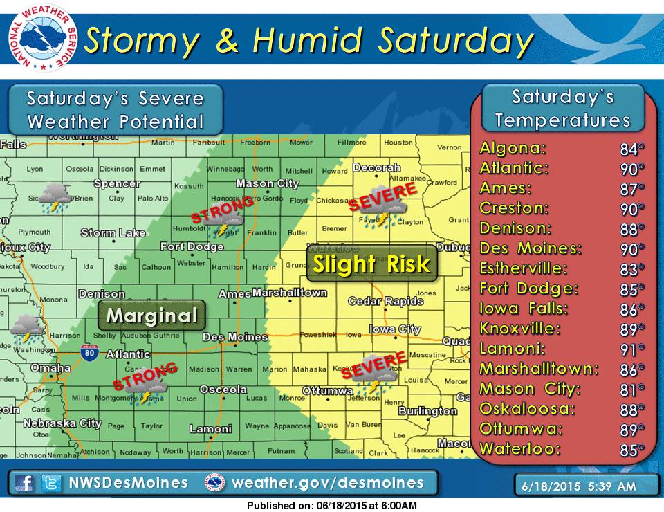 The National Weather Service in Des Moines reports Saturday will be hot and humid, with the potential for severe weather.With High temperatures in the upper 80s to low 90’s Saturday, and Dewpoint values in the low to mid-70’s, the Heat index (or, how it feels) will be in the mid- to upper 90’s, with a few places reaching 100 degrees.
The heat and humidity will be most prevalent along and south of Interstate 80, with the warmest temperatures off to the south. There is also a threat of severe weather Saturday, with a “marginal” risk for strong storms weather over much of the KJAN listening area, and a slight risk of severe storms over parts of central Iowa, and most of the eastern half of the State. The primary threats Saturday afternoon and evening include large hail, damaging winds, and the possibility of tornadoes.
The Weather Service says you need to prepare for this heat spell, by making sure air conditioning works, drink plenty of water, never leave children or pets alone in closed vehicles, stay indoors as much as possible and limit exposure to the sun.
Today: Partly sunny, with a high near 80. East northeast wind 7 to 10 mph.
Tonight: Partly cloudy, with a low around 62. East northeast wind 5 to 8 mph becoming calm.
Friday: Mostly sunny, with a high near 84. Light east wind becoming southeast 6 to 11 mph in the morning. Winds could gust as high as 18 mph.
Friday Night: Partly cloudy, with a low around 68. South southeast wind 7 to 10 mph.
Saturday: A 30 percent chance of showers and thunderstorms after 1pm. Mostly sunny, with a high near 89. South southeast wind 11 to 15 mph, with gusts as high as 29 mph. New rainfall amounts of less than a tenth of an inch, except higher amounts possible in thunderstorms.
Saturday Night: Partly cloudy, with a low around 67.
Sunday: A 30 percent chance of showers and thunderstorms. Mostly sunny, with a high near 85.
Fears about flooding are rising as more rain is in the forecast over the next few days for parts of the state that are still soggy from up to five-inches of rain last weekend. Meteorologist David Sheets, at the National Weather Service office in the Quad Cities, says eastern Iowa is filling what was until recently a moisture deficit.
“As of a couple weeks ago, there were parts of eastern Iowa that were starting to enter a D-zero drought,” Sheets says. “River levels were at seasonal normals and in some instances, below normal.” That’s changing though and Sheets admits too much rain, too soon, will cause more flash flooding in areas like Cedar Rapids. Still, the Weather Service is -not- predicting widespread flooding like in 2008.
“The danger we have is the saturated soil conditions and stream levels running high,” Sheets says. “If we were to get a thunderstorm with heavy rainfall, it can quickly lead to flash flooding in urban areas and along streams. That’s what we’re most prone to right now.” The current forecast calls for more scattered storms across much of Iowa through Sunday but the showers are -not- expected to bring significant amounts of rain.
(Radio Iowa)
740 AM CDT WED JUN 17 2015
…The Flood Warning is cancelled for the following rivers…
West Nishnabotna River Near Riverton affecting Fremont County.
East Nishnabotna River At Riverton affecting Fremont County.
Nishnabotna River Near Hamburg affecting Fremont County.
AUDUBON-GUTHRIE-CASS-ADAIR-ADAMS-UNION-TAYLOR-RINGGOLD COUNTIES…
701 AM CDT WED JUN 17 2015
…PATCHY DENSE FOG EARLY THIS MORNING…
PATCHY DENSE FOG WITHIN AN AREA OF FOG HAS DEVELOPED OVER
SOUTHWEST IOWA EARLY THIS MORNING. VISIBILITY HAS BEEN REDUCED
TO LESS THAN ONE QUARTER MILE AT TIMES…ESPECIALLY IN LOW LYING
AREAS AND NEAR RIVER BOTTOMS. DRIVERS SHOULD BE CAUTIOUS THROUGH 900 AM CDT THIS MORNING WHEN THE FOG IS EXPECTED TO LIFT. USE LOW BEAM HEADLIGHTS AND ALLOW EXTRA DISTANCE BETWEEN YOU AND OTHER VEHICLES AHEAD OF YOU. BE ESPECIALLY CAUTIOUS WHEN APPROACHING INTERSECTIONS AND RAILROAD CROSSINGS AS VEHICLES OR TRAINS MAY BE HIDDEN BY DENSE FOG. CONDITIONS WILL IMPROVE OVER THE NEXT TWO HOURS.
The Freese-Notis (podcast) weather forecast for Atlantic & the KJAN listening area, and weather information for Atlantic.
Podcast: Play in new window | Download (1.1MB)
Subscribe: RSS
407 AM CDT WED JUN 17 2015
EARLY THIS MORNING…MOSTLY CLOUDY. SOUTHEAST WIND AROUND 5 MPH.
TODAY…MOSTLY CLOUDY. SCATTERED THUNDERSTORMS IN THE LATE MORNING AND AFTERNOON. HIGH IN THE MID 80S. SOUTHWEST WIND 5 TO 10 MPH. CHANCE OF THUNDERSTORMS 50 PERCENT.
TONIGHT…MOSTLY CLOUDY. A CHANCE OF THUNDERSTORMS THROUGH MIDNIGHT…THEN A SLIGHT CHANCE OF THUNDERSTORMS AFTER MIDNIGHT. A CHANCE OF THUNDERSTORMS EARLY IN THE MORNING. LOW IN THE MID 60S. WEST WIND NEAR 10 MPH. CHANCE OF THUNDERSTORMS 40 PERCENT.
THURSDAY…PARTLY SUNNY. A CHANCE OF THUNDERSTORMS UNTIL LATE AFTERNOON…THEN A SLIGHT CHANCE OF THUNDERSTORMS LATE IN THE AFTERNOON. HIGH IN THE LOWER 80S. EAST WIND NEAR 10 MPH. CHANCE OF THUNDERSTORMS 50 PERCENT.
THURSDAY NIGHT…PARTLY CLOUDY THROUGH MIDNIGHT THEN BECOMING MOSTLY CLOUDY. LOW IN THE MID 60S. SOUTHEAST WIND NEAR 10 MPH.
FRIDAY…MOSTLY SUNNY. HIGH IN THE LOWER 80S. SOUTHEAST WIND 5 TO 15 MPH.
SATURDAY…MOSTLY CLOUDY WITH A 40 PERCENT CHANCE OF THUNDERSTORMS. HIGH IN THE UPPER 80S.
FLOOD STATEMENT
NATIONAL WEATHER SERVICE OMAHA/VALLEY NEBRASKA
632 AM CDT TUE JUN 16 2015
A Flood Warning continues until 3:20-a.m. Wednesday for the following rivers:
• West Nishnabotna River Near Riverton affecting Fremont County.
• East Nishnabotna River At Red Oak affecting Montgomery County.
• East Nishnabotna River At Riverton affecting Fremont County.
• Nishnabotna River Near Hamburg affecting Fremont County.
PRECAUTIONARY/PREPAREDNESS ACTIONS…
Do not drive cars through areas where water covers the road. The
water depth may be too great to allow your vehicle to pass safely.
Turn around…don`t drown!


