
220 PM CDT THU MAY 26 2016
THE NATIONAL WEATHER SERVICE IN OMAHA HAS ISSUED A
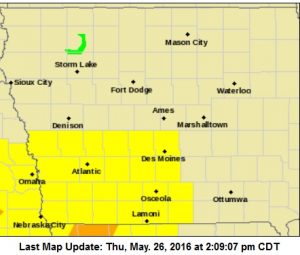
* SEVERE THUNDERSTORM WARNING FOR…
SOUTHWESTERN PAGE COUNTY IN SOUTHWESTERN IOWA…
EASTERN FREMONT COUNTY IN SOUTHWESTERN IOWA…
* UNTIL 245 PM CDT
* AT 220 PM CDT…A SEVERE THUNDERSTORM WAS LOCATED 6 MILES SOUTHEAST OF HAMBURG…OR 12 MILES NORTHWEST OF TARKIO…MOVING NORTHEAST AT 30 MPH.
HAZARD…60 MPH WIND GUSTS AND QUARTER SIZE HAIL.
SOURCE…RADAR INDICATED.
IMPACT…HAIL DAMAGE TO VEHICLES IS EXPECTED. EXPECT WIND DAMAGE
TO ROOFS…SIDING AND TREES.
* LOCATIONS IMPACTED INCLUDE…
SHENANDOAH…HAMBURG…FARRAGUT AND RIVERTON.
THIS INCLUDES THE FOLLOWING HIGHWAYS…
HIGHWAY 59 IN IOWA BETWEEN MILE MARKERS 1 AND 16.
INTERSTATE 29 NEAR MILE MARKER 1.
PRECAUTIONARY/PREPAREDNESS ACTIONS…
FOR YOUR PROTECTION MOVE TO AN INTERIOR ROOM ON THE LOWEST FLOOR OF A BUILDING.
TORNADO WATCH OUTLINE UPDATE FOR WT 216
NWS STORM PREDICTION CENTER NORMAN OK
210 PM CDT THU MAY 26 2016

TORNADO WATCH 216 IS IN EFFECT UNTIL 1000 PM CDT FOR THE
FOLLOWING LOCATIONS.  IOWA COUNTIES INCLUDED ARE

ADAIR                ADAMS               AUDUBON
CASS                 CLARKE              DALLAS
DECATUR              GUTHRIE             LUCAS
MADISON              POLK                RINGGOLD
TAYLOR               UNION               WARREN
WAYNE
* PRIMARY THREATS INCLUDE…
A FEW TORNADOES LIKELY WITH A COUPLE INTENSE TORNADOES POSSIBLE.
WIDESPREAD LARGE HAIL AND ISOLATED VERY LARGE HAIL EVENTS TO 2.5
INCHES IN DIAMETER LIKELY. SCATTERED DAMAGING WIND GUSTS TO 70 MPH
POSSIBLE.
PROBABILITY TABLE:
PROB OF 2 OR MORE TORNADOES : 60%
PROB OF 1 OR MORE STRONG /F2-F5/ TORNADOES : 30%
PROB OF 10 OR MORE SEVERE WIND EVENTS : 40%
PROB OF 1 OR MORE WIND EVENTS > 75 MPH : 10%
PROB OF 10 OR MORE SEVERE HAIL EVENTS : 90%
PROB OF 1 OR MORE HAIL EVENTS > 2 INCHES : 60%
PROB OF 6 OR MORE COMBINED SEVERE HAIL/WIND EVENTS : >95%
TORNADO WATCH OUTLINE UPDATE FOR WT 216
NWS STORM PREDICTION CENTER NORMAN OK
210 PM CDT THU MAY 26 2016

TORNADO WATCH 216 IS IN EFFECT UNTIL 1000 PM CDT FOR THE
 FOLLOWING LOCATIONS

IAC001-003-009-029-039-049-053-077-117-121-153-159-173-175-181-
185-270300-
/O.NEW.KWNS.TO.A.0216.160526T1910Z-160527T0300Z/

IA
.    IOWA COUNTIES INCLUDED ARE

ADAIR                ADAMS               AUDUBON
CASS                 CLARKE              DALLAS
DECATUR              GUTHRIE             LUCAS
MADISON              POLK                RINGGOLD
TAYLOR               UNION               WARREN
WAYNE
There are unconfirmed reports of a tornado derailing several cars of a freight train early this (Thursday) morning in western Iowa, yet, that’s among very few twisters spotted in the state so far this year. Meteorologist Craig Cogi, at the National Weather Service, says the spring and summer months have been relatively quiet in Iowa the past three years.
“Typically through this time of the year, we see about 17 or 18 tornadoes and the last three years, we’ve been right about 12 tornadoes,” Cogil says. “Certainly, we’ve been behind the curve as far as that goes and I don’t think anyone is going to complain.”
While last year had a slow start, there were eventually 58 tornadoes reported statewide. Cogil was asked if there’s a reason why the number is again so low this year. “No, not really,” he says. “It’s just the pattern that we get in and it’s just not been conducive for tornado development during the spring and early summer the past few years.”
Cogil says Iowans need to be watchful for the potential for severe weather now and through the upcoming Memorial Day weekend. “We’re going to see a couple of different systems move across the Midwest,” he says. “Particularly, we’re looking at tomorrow, on Thursday, the potential of severe weather across much of Iowa in addition to the threat of tornadoes. People just need to watch the weather and look for updates.”
See the forecast for your area at weather-dot-gov.
(Radio Iowa)
AREA COUNTIES: SAC-CRAWFORD-CARROLL-AUDUBON-GUTHRIE-DALLAS-CASS-ADAIR-MADISON-ADAMS-UNION-TAYLOR-RINGGOLD....
824 AM CDT THU MAY 26 2016
THERE IS A SLIGHT RISK OF SEVERE WEATHER TODAY INTO TONIGHT. THE HIGHEST RISK IS OVER SOUTHWESTERN IOWA. ALL SEVERE THREATS ARE POSSIBLE INCLUDING LARGE HAIL…DAMAGING WINDS…AND ISOLATED TORNADOES. HEAVY RAINFALL IS ALSO POSSIBLE THIS EVENING AND TONIGHT…WHICH COULD LEAD TO LOCALIZED FLOODING.
INTERMITTENT THUNDERSTORMS ARE EXPECTED TOMORROW (FRIDAY) THROUGH WEDNESDAY OF NEXT WEEK. THERE IS A LOW RISK FOR SEVERE THUNDERSTORMS ON FRIDAY AND SATURDAY.
SPOTTER INFORMATION STATEMENT…
SPOTTER ACTIVATION WILL LIKELY BE NEEDED THIS AFTERNOON INTO
TONIGHT.
Today: P/Cldy to Cldy w/scattered showers & thunderstorms again this afternoon, some may be severe. High near 80. SE @ 10-20.
Tonight: Showers and thunderstorms likely. Some of the storms be severe this evening, and could produce heavy rain. Low around 64. East southeast wind 10mph. .
Friday: A 40% chance of showers & thunderstorms early; Mostly cloudy. High 82. S/SE @ 10-20.
Friday Night: Showers and thunderstorms likely. Llow around 63
Saturday: Mo. Cldy w/a 50% chance of showers & thunderstorms. High near 80. South southeast wind 7 to 13 mph. New rainfall amounts between a quarter and half of an inch possible.
Saturday Night: A 30 percent chance of showers and thunderstorms. Low around 59.
Sunday: P/Cldy w/isolated showers and thunderstorms. High near 84.
Wednesday’s High in Atlantic was 80. Our 24-hour Low thru 7-a.m. today was 57. We received 1.84” of rain, most of that early this morning. Last year on this date, our High in Atlantic was 73 and the low was 52. The All-time Record High in Atlantic on this date was 96 in 1926. The Record Low was 30 in 1901.
Thunderstorm winds or possibly a tornado caused a Union Pacific Train to derail early this (Thursday) morning, in Crawford County. Emergency Management Coordinator Greg Miller told KJAN News some of the train’s container cars derailed between 2-and 2:25-a.m., about a mile and a half west of Westside. None of the cars were toppled over, though. The train was carrying some hazardous material, but as of the latest report, nothing was leaking, and no injuries were reported.
Miller said the train’s engineers swore a tornado caused the damage, as several of the containers inside the rail cars were sucked out of those cars. He said winds gusted up to 75-miles per hour for a short time. All the crossings are open in area towns, but power lines were down in several communities. Charter Oak, Dow City and Denison all reported scattered power outages. Winds just southwest of Denison at the airport, peaked at 87-mph at around 2:15-a.m. A few minutes earlier, winds were gusting to near 60-mph in the same area.
The National Weather Service says Arcadia, in Carroll County, was hit with near 60-mph winds and quarter-sized hail at around 2:30-a.m. Miller said the town was hit pretty hard. Elsewhere, a resident of Audubon County who lives about 7-to 8-miles east of Exira off 280th Street, reports a solid wood corn crib that’s stood the test of time for over 50-years, was blown over sometime between 2:25-and 2:45-a.m. today. And, a little southwest of Minden, in Dallas County, half-dollar size hail was reported at around 2:35-a.m.
254 AM CDT THU MAY 26 2016

THE NATIONAL WEATHER SERVICE IN DES MOINES  HAS ISSUED A

* SEVERE THUNDERSTORM WARNING FOR...
  SOUTHERN WEBSTER COUNTY IN CENTRAL IOWA...
  SOUTHWESTERN STORY COUNTY IN CENTRAL IOWA...
  EASTERN GUTHRIE COUNTY IN WEST CENTRAL IOWA...
  WESTERN HAMILTON COUNTY IN CENTRAL IOWA...
  SOUTHEASTERN CALHOUN COUNTY IN WEST CENTRAL IOWA...
  NORTHWESTERN POLK COUNTY IN CENTRAL IOWA...
  NORTHEASTERN CARROLL COUNTY IN WEST CENTRAL IOWA...
  GREENE COUNTY IN WEST CENTRAL IOWA...
  BOONE COUNTY IN CENTRAL IOWA...
  NORTHERN DALLAS COUNTY IN CENTRAL IOWA...

* UNTIL 345 AM CDT

* AT 254 AM CDT...SEVERE THUNDERSTORMS WERE LOCATED ALONG A LINE
  EXTENDING FROM 4 MILES NORTH OF LAKE CITY TO 7 MILES SOUTH OF
  PANORA...MOVING EAST AT 60 MPH.

  HAZARD...60 MPH WIND GUSTS AND PENNY SIZE HAIL.

  SOURCE...RADAR INDICATED.

  IMPACT...EXPECT DAMAGE TO ROOFS...SIDING...AND TREES.


