Early This Morning: Mostly clear. West wind near 10 mph.
Today: Sunny…warmer. High in the mid 80s. Southwest wind near 10 mph.
Tonight: Partly cloudy. A 20 percent chance of thunderstorms after midnight. Low around 60. Southwest wind near 10 mph.
Memorial Day: Mostly sunny with a 30 percent chance of thunderstorms. High in the lower 80s. South wind near 10 mph.
Monday Night: Mostly cloudy with a 50 percent chance of thunderstorms. Low in the lower 60s. South wind 5 to 10 mph.
Tuesday: Thunderstorms likely. High in the mid 70s. South wind 5 to 10 mph. Chance of thunderstorms 60 percent.
Tuesday Night: Cloudy with a 40 percent chance of thunderstorms. Low in the upper 50s.
Wednesday: Partly sunny. High in the mid 70s.
Today: Partly Sunny w/a 40% chance of showers & thunderstorms. High near 78. South southwest wind 5 to 15 mph.
Tonight: P/Cldy w/a 30% chance of showers & thunderstorms. Low around 60.
Sunday: P/Sunny. High 83. W/Sw @ 10-15.
Sunday Night: P/Cldy w/a 30% chance of showers & thunderstorms. Low around 63.
Memorial Day: P/Sunny w/a 40% chance of afternoon showers & thunderstorms. High near 85.
Tuesday: Mo. Cldy w/a 60% chance of showers & thunderstorms. High 77.
Friday’s High in Atlantic was 77. Our 24-hour Low thru 7-a.m. today was 59. We received .26” rain over the past 24-hours ending today at 7-a.m.. The total rainfall in Atlantic from Monday through this morning is 6.05-inches. Last year on this date, our High in Atlantic was 73 and the low was 60. The All-time Record High in Atlantic on this date was 95 in 1895. The Record Low was 29 in 1894.
403 AM CDT SAT MAY 28 2016
EARLY THIS MORNING…PERIODS OF SHOWERS AND ISOLATED THUNDERSTORMS. SOUTH WIND NEAR 10 MPH. CHANCE OF PRECIPITATION 80 PERCENT.
TODAY…MOSTLY CLOUDY. SCATTERED SHOWERS AND ISOLATED THUNDERSTORMS THROUGH MID MORNING…THEN SCATTERED THUNDERSTORMS IN THE LATE MORNING AND AFTERNOON. HIGH IN THE MID 70S. SOUTHWEST WIND 5 TO 15 MPH. CHANCE OF PRECIPITATION 50 PERCENT.
TONIGHT…MOSTLY CLOUDY WITH ISOLATED THUNDERSTORMS IN THE EVENING…THEN MOSTLY CLOUDY WITH A SLIGHT CHANCE OF SHOWERS AND ISOLATED THUNDERSTORMS BEFORE MIDNIGHT. PARTLY CLOUDY AFTER MIDNIGHT. LOW IN THE MID 50S. SOUTHWEST WIND NEAR 10 MPH. GUSTS UP TO 20 MPH THROUGH MIDNIGHT. CHANCE OF PRECIPITATION 20 PERCENT.
SUNDAY…MOSTLY SUNNY. HIGH IN THE LOWER 80S. SOUTHWEST WIND NEAR 10 MPH.
SUNDAY NIGHT…PARTLY CLOUDY THROUGH MIDNIGHT THEN BECOMING MOSTLY CLOUDY. A 30 PERCENT CHANCE OF THUNDERSTORMS. LOW AROUND 60. SOUTH WIND NEAR 10 MPH.
MEMORIAL DAY…PARTLY SUNNY. A CHANCE OF THUNDERSTORMS IN THE MORNING…THEN THUNDERSTORMS LIKELY IN THE AFTERNOON. HIGH IN THE LOWER 80S. SOUTH WIND NEAR 5 MPH INCREASING TO 5 TO 15 MPH IN THE AFTERNOON. CHANCE OF THUNDERSTORMS 60 PERCENT.
MONDAY NIGHT…MOSTLY CLOUDY WITH A 50 PERCENT CHANCE OF THUNDERSTORMS. LOW IN THE LOWER 60S.
TUESDAY…THUNDERSTORMS LIKELY. HIGH IN THE UPPER 70S. CHANCE OF THUNDERSTORMS 60 PERCENT.
340 AM CDT SAT MAY 28 2016
…FLASH FLOOD WATCH IS CANCELLED…
THE FLASH FLOOD WATCH (which was in effect until 7-a.m.) FOR PORTIONS OF SOUTH CENTRAL IOWA…SOUTHEAST IOWA AND SOUTHWEST IOWA HAS BEEN CANCELLED.
HEAVY RAIN IS NOT ANTICIPATED OVER SOUTHERN IOWA THROUGH THE REMAINDER OF THE MORNING. ADDITIONAL LIGHT SHOWERS ARE POSSIBLE, BUT WILL NOT BE ENOUGH TO POSE ANY THREAT OF FLASH FLOODING.
753 PM CDT FRI MAY 27 2016 …HEAVY RAIN AND FLASH FLOODING POSSIBLE TONIGHT… .A STORM SYSTEM LIFTING NORTHWARD FROM THE SOUTHERN PLAINS INTO OUR REGION TONIGHT WILL BRING THE POTENTIAL FOR HEAVY RAINFALL. ALTHOUGH THE HEAVIEST RAINFALL IS EXPECTED TO FALL FROM SOUTH CENTRAL INTO SOUTHEAST IOWA…HEAVY RAIN WHICH FELL THURSDAY EVENING IN SOUTHWEST IOWA HAS MADE SOME LOCATIONS THERE MORE SUSCEPTIBLE TO FLASH FLOODING TONIGHT.
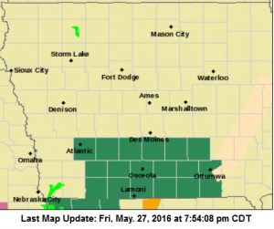
Flash Flood Watch for counties in green
CASS-ADAIR-MADISON-ADAMS-UNION-RINGGOLD– 753 PM CDT FRI MAY 27 2016 …FLASH FLOOD WATCH IN EFFECT UNTIL 7 AM CDT SATURDAY… THE NATIONAL WEATHER SERVICE IN DES MOINES HAS ISSUED A * FLASH FLOOD WATCH FOR PORTIONS OF SOUTH CENTRAL IOWA… SOUTHEAST IOWA AND SOUTHWEST IOWA… * UNTIL 7 AM CDT SATURDAY * LOCALLY HEAVY RAINFALL IS EXPECTED TO FALL TONIGHT WITH THE BEST CHANCES SOUTH OF INTERSTATE 80. ALTHOUGH THE HEAVIEST RAINFALL IS EXPECTED TO FALL FROM SOUTH CENTRAL INTO SOUTHEAST IOWA…HEAVY RAIN WHICH FELL THURSDAY EVENING IN SOUTHWEST IOWA HAS MADE SOME LOCATIONS THERE MORE SUSCEPTIBLE TO FLASH FLOODING TONIGHT. * FLASH FLOODING CAN BE ESPECIALLY DANGEROUS AT NIGHT BECAUSE IT CAN BE MORE DIFFICULT TO SEE FLOODED ROADS. EXERCISE CAUTION IF YOU PLAN TO TRAVEL TONIGHT. PRECAUTIONARY/PREPAREDNESS ACTIONS… A FLASH FLOOD WATCH MEANS THAT CONDITIONS MAY DEVELOP THAT LEAD TO FLASH FLOODING. FLASH FLOODING IS A VERY DANGEROUS SITUATION. YOU SHOULD MONITOR LATER FORECASTS AND BE PREPARED TO TAKE ACTION SHOULD FLASH FLOOD WARNINGS BE ISSUED.
Today: Cloudy to P/Cldy, w/light rain ending this morning; Showers & thunderstorms redeveloping this afternoon. High near 80. S/SE @ 5-10. New rainfall amounts between a quarter and half of an inch possible.
Tonight: Cloudy w/an 80% chance of showers & thunderstorms. Low around 60. New rainfall amounts between a quarter and half of an inch possible.
Saturday: Showers and thunderstorms ending in the morning. Cldy to P/Cldy. High 78. W/SW @ 10-15. New rainfall amounts between a tenth and quarter of an inch, except higher amounts possible in thunderstorms.
Sat. Night: Cloudy w/a 30% chance of showers and thunderstorms thru midnight. Low around 58.
Sunday: P/Cldy. High near 84.
Sun. Night: P/Cldy w/a slight chance of showers and thunderstorms. Low around 61.
Memorial Day: P/Cldy w/isolated showers and thunderstorms. High near 84.
Thursday’s High in Atlantic was 83. Our 24-hour Low thru 7-a.m. today was 58. We received 3.51” of rain from 7-a.m. Thursday through 7-a.m. today, w/most of that falling late Thursday afternoon into late Thursday night.
The total rainfall in Atlantic (at KJAN) from Monday through this morning is 5.79-inches.
Last year on this date, our High in Atlantic was 83 and the low was 54. The All-time Record High in Atlantic on this date was 91 in 1931. The Record Low was 31 in 1907.
Thunderstorms that slowly and loudly rumbled across southwest and western Iowa Thursday afternoon and evening, left many streets in Atlantic closed for several hours because of high water due to heavy, heavy rain and flash flooding. At the KJAN studios on the northern limits of Atlantic, we measured 3.51-inches of rainfall (from 7-a.m. Thursday through 7-a.m. today). The skies dumped even more rain in town, with Bull Creek flooding leading to water rushing into intersections stretching from 11th and Roosevelt northwest to the vicinity of 11th and Linn near the Washington/Schuler Elementary School, where Police blocked traffic for a time due to high water.
Lawns and streets along the path of the creek, from Oak to Elm, and 11th to 7th Street, were filled with water that had nowhere to go because the storm sewer system couldn’t keep up. Further north, intersections with rapidly flowing, deep water were barricaded or manned by emergency workers, including police, volunteer firefighters and others, but there were some stalled vehicles seen, including in the area of 4th and Elm, and following the initial deluge of rain, at 7th and Walnut, which was one of the intersections to be blocked-off, twice during the evening.
By late Thursday evening, the flood threat had subsided, as rains trickled-off to sprinkles. As of this morning, the Cass County Communications Center said they had no reports of any road closures in Atlantic, but motorists should be watchful for debris on the road from flooding, and tree limbs that may have fallen from the gusty winds that accompanied Thursday’s storms.
Flash Flooding was also reported Thursday in Fremont County, 5-miles south of Thurman, near Percival, and in Tabor. A storm spotter in Panora late Thursday night measured 3.55-inches of rain in their gauge, from storms that fell late Thursday afternoon and evening.
338 AM CDT FRI MAY 27 2016
EARLY THIS MORNING…NUMEROUS THUNDERSTORMS. SOUTH WIND 10 TO 15 MPH WITH GUSTS TO AROUND 40 MPH. CHANCE OF THUNDERSTORMS 60 PERCENT.
TODAY…CLOUDY WITH SCATTERED THUNDERSTORMS. HIGH IN THE MID 70S. SOUTHEAST WIND 5 TO 10 MPH. CHANCE OF THUNDERSTORMS 50 PERCENT.
TONIGHT…MOSTLY CLOUDY. A CHANCE OF THUNDERSTORMS THROUGH MIDNIGHT…THEN THUNDERSTORMS AFTER MIDNIGHT. LOW AROUND 60. SOUTHEAST WIND NEAR 5 MPH. CHANCE OF THUNDERSTORMS 80 PERCENT.
SATURDAY…MOSTLY CLOUDY. THUNDERSTORMS LIKELY THROUGH MID MORNING…THEN A CHANCE OF THUNDERSTORMS IN THE LATE MORNING AND AFTERNOON. HIGH IN THE MID 70S. SOUTH WIND NEAR 10 MPH SHIFTING TO THE SOUTHWEST IN THE AFTERNOON. CHANCE OF THUNDERSTORMS 60 PERCENT.
SATURDAY NIGHT…MOSTLY CLOUDY WITH A 50 PERCENT CHANCE OF THUNDERSTORMS THROUGH MIDNIGHT…THEN PARTLY CLOUDY AFTER MIDNIGHT. LOW IN THE UPPER 50S. WEST WIND 5 TO 10 MPH.
SUNDAY…MOSTLY SUNNY. HIGH IN THE LOWER 80S. WEST WIND 5 TO 10 MPH.
SUNDAY NIGHT…PARTLY CLOUDY WITH A 20 PERCENT CHANCE OF THUNDERSTORMS. LOW IN THE LOWER 60S.
MEMORIAL DAY…PARTLY SUNNY WITH A 40 PERCENT CHANCE OF THUNDERSTORMS. HIGH IN THE LOWER 80S.
These pictures are from Cass County Emergency Management Coordinator Mike Kennon…(Click on the images to once and then when the separate file opens, to enlarge)