
FLASH FLOOD WARNING
NATIONAL WEATHER SERVICE OMAHA/VALLEY NEBRASKA
431 PM CDT THU MAY 26 2016

THE NATIONAL WEATHER SERVICE IN OMAHA HAS ISSUED A

* FLASH FLOOD WARNING FOR...
  SOUTHEASTERN POTTAWATTAMIE COUNTY IN SOUTHWESTERN IOWA...

* UNTIL 730 PM CDT

* AT 431 PM CDT...DOPPLER RADAR INDICATED A THUNDERSTORM PRODUCING
  HEAVY RAIN ACROSS THE WARNED AREA. OVER TWO INCHES OF RAIN HAVE
  ALREADY FALLEN. FLASH FLOODING IS EXPECTED TO BEGIN SHORTLY.

* SOME LOCATIONS THAT WILL EXPERIENCE FLOODING INCLUDE...
  CARSON...MACEDONIA...FARM CREEK PUBLIC WILDLIFE AREA AND OLD TOWN
  PARK.

THIS INCLUDES HIGHWAY 59 IN IOWA BETWEEN MILE MARKERS 41 AND 44.

PRECAUTIONARY/PREPAREDNESS ACTIONS...

MOVE TO HIGHER GROUND NOW. ACT QUICKLY TO PROTECT YOUR LIFE.
PAGE IA-FREMONT IA-
354 PM CDT THU MAY 26 2016
THE NATIONAL WEATHER SERVICE IN OMAHA HAS ISSUED A
* FLOOD ADVISORY FOR…
NORTHWESTERN PAGE COUNTY IN SOUTHWESTERN IOWA…
SOUTHEASTERN FREMONT COUNTY IN SOUTHWESTERN IOWA…
* UNTIL 700 PM CDT
* AT 353 PM CDT…DOPPLER RADAR INDICATED HEAVY RAIN DUE TO
THUNDERSTORMS. THIS WILL CAUSE MINOR FLOODING IN THE ADVISORY AREA.
OVER AN INCH OF RAIN HAD FALLEN FROM STORMS THAT MOVED THROUGH EARLIER.
* SOME LOCATIONS THAT WILL EXPERIENCE FLOODING INCLUDE…
SHENANDOAH…ESSEX…FARRAGUT…
RIVERTON AND PIERCE RECREATION AREA.
PRECAUTIONARY/PREPAREDNESS ACTIONS…
EXCESSIVE RUNOFF FROM HEAVY RAINFALL WILL CAUSE FLOODING OF SMALL CREEKS AND STREAMS…AS WELL AS FARM AND COUNTRY ROADS. DO NOT ATTEMPT TO TRAVEL ACROSS FLOODED ROADS. FIND ALTERNATE ROUTES.
PAGE IA-FREMONT IA-COUNTIES
248 PM CDT THU MAY 26 2016
…A SEVERE THUNDERSTORM WARNING REMAINS IN EFFECT UNTIL 315 PM CDT FOR NORTHWESTERN PAGE AND NORTHEASTERN FREMONT COUNTIES…AT 247 PM CDT…A SEVERE THUNDERSTORM WAS LOCATED NEAR SHENANDOAH…OR 22 MILES NORTH OF TARKIO…MOVING NORTHEAST AT 35 MPH.
HAZARD…60 MPH WIND GUSTS AND QUARTER SIZE HAIL.
220 PM CDT THU MAY 26 2016
THE NATIONAL WEATHER SERVICE IN OMAHA HAS ISSUED A
* SEVERE THUNDERSTORM WARNING FOR…
SOUTHWESTERN PAGE COUNTY IN SOUTHWESTERN IOWA…
EASTERN FREMONT COUNTY IN SOUTHWESTERN IOWA…
* UNTIL 245 PM CDT
* AT 220 PM CDT…A SEVERE THUNDERSTORM WAS LOCATED 6 MILES SOUTHEAST OF HAMBURG…OR 12 MILES NORTHWEST OF TARKIO…MOVING NORTHEAST AT 30 MPH.
HAZARD…60 MPH WIND GUSTS AND QUARTER SIZE HAIL.
SOURCE…RADAR INDICATED.
IMPACT…HAIL DAMAGE TO VEHICLES IS EXPECTED. EXPECT WIND DAMAGE
TO ROOFS…SIDING AND TREES.
* LOCATIONS IMPACTED INCLUDE…
SHENANDOAH…HAMBURG…FARRAGUT AND RIVERTON.
THIS INCLUDES THE FOLLOWING HIGHWAYS…
HIGHWAY 59 IN IOWA BETWEEN MILE MARKERS 1 AND 16.
INTERSTATE 29 NEAR MILE MARKER 1.
PRECAUTIONARY/PREPAREDNESS ACTIONS…
FOR YOUR PROTECTION MOVE TO AN INTERIOR ROOM ON THE LOWEST FLOOR OF A BUILDING.
TORNADO WATCH OUTLINE UPDATE FOR WT 216
NWS STORM PREDICTION CENTER NORMAN OK
210 PM CDT THU MAY 26 2016

TORNADO WATCH 216 IS IN EFFECT UNTIL 1000 PM CDT FOR THE
FOLLOWING LOCATIONS.  IOWA COUNTIES INCLUDED ARE

ADAIR                ADAMS               AUDUBON
CASS                 CLARKE              DALLAS
DECATUR              GUTHRIE             LUCAS
MADISON              POLK                RINGGOLD
TAYLOR               UNION               WARREN
WAYNE
* PRIMARY THREATS INCLUDE…
A FEW TORNADOES LIKELY WITH A COUPLE INTENSE TORNADOES POSSIBLE.
WIDESPREAD LARGE HAIL AND ISOLATED VERY LARGE HAIL EVENTS TO 2.5
INCHES IN DIAMETER LIKELY. SCATTERED DAMAGING WIND GUSTS TO 70 MPH
POSSIBLE.
PROBABILITY TABLE:
PROB OF 2 OR MORE TORNADOES : 60%
PROB OF 1 OR MORE STRONG /F2-F5/ TORNADOES : 30%
PROB OF 10 OR MORE SEVERE WIND EVENTS : 40%
PROB OF 1 OR MORE WIND EVENTS > 75 MPH : 10%
PROB OF 10 OR MORE SEVERE HAIL EVENTS : 90%
PROB OF 1 OR MORE HAIL EVENTS > 2 INCHES : 60%
PROB OF 6 OR MORE COMBINED SEVERE HAIL/WIND EVENTS : >95%
TORNADO WATCH OUTLINE UPDATE FOR WT 216
NWS STORM PREDICTION CENTER NORMAN OK
210 PM CDT THU MAY 26 2016

TORNADO WATCH 216 IS IN EFFECT UNTIL 1000 PM CDT FOR THE
 FOLLOWING LOCATIONS

IAC001-003-009-029-039-049-053-077-117-121-153-159-173-175-181-
185-270300-
/O.NEW.KWNS.TO.A.0216.160526T1910Z-160527T0300Z/

IA
.    IOWA COUNTIES INCLUDED ARE

ADAIR                ADAMS               AUDUBON
CASS                 CLARKE              DALLAS
DECATUR              GUTHRIE             LUCAS
MADISON              POLK                RINGGOLD
TAYLOR               UNION               WARREN
WAYNE
There are unconfirmed reports of a tornado derailing several cars of a freight train early this (Thursday) morning in western Iowa, yet, that’s among very few twisters spotted in the state so far this year. Meteorologist Craig Cogi, at the National Weather Service, says the spring and summer months have been relatively quiet in Iowa the past three years.
“Typically through this time of the year, we see about 17 or 18 tornadoes and the last three years, we’ve been right about 12 tornadoes,” Cogil says. “Certainly, we’ve been behind the curve as far as that goes and I don’t think anyone is going to complain.”
While last year had a slow start, there were eventually 58 tornadoes reported statewide. Cogil was asked if there’s a reason why the number is again so low this year. “No, not really,” he says. “It’s just the pattern that we get in and it’s just not been conducive for tornado development during the spring and early summer the past few years.”
Cogil says Iowans need to be watchful for the potential for severe weather now and through the upcoming Memorial Day weekend. “We’re going to see a couple of different systems move across the Midwest,” he says. “Particularly, we’re looking at tomorrow, on Thursday, the potential of severe weather across much of Iowa in addition to the threat of tornadoes. People just need to watch the weather and look for updates.”
See the forecast for your area at weather-dot-gov.
(Radio Iowa)
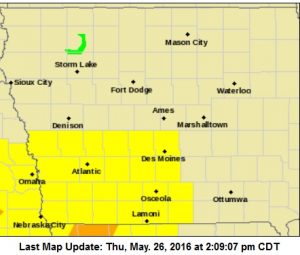
AREA COUNTIES: SAC-CRAWFORD-CARROLL-AUDUBON-GUTHRIE-DALLAS-CASS-ADAIR-MADISON-ADAMS-UNION-TAYLOR-RINGGOLD....
824 AM CDT THU MAY 26 2016
THERE IS A SLIGHT RISK OF SEVERE WEATHER TODAY INTO TONIGHT. THE HIGHEST RISK IS OVER SOUTHWESTERN IOWA. ALL SEVERE THREATS ARE POSSIBLE INCLUDING LARGE HAIL…DAMAGING WINDS…AND ISOLATED TORNADOES. HEAVY RAINFALL IS ALSO POSSIBLE THIS EVENING AND TONIGHT…WHICH COULD LEAD TO LOCALIZED FLOODING.
INTERMITTENT THUNDERSTORMS ARE EXPECTED TOMORROW (FRIDAY) THROUGH WEDNESDAY OF NEXT WEEK. THERE IS A LOW RISK FOR SEVERE THUNDERSTORMS ON FRIDAY AND SATURDAY.
SPOTTER INFORMATION STATEMENT…
SPOTTER ACTIVATION WILL LIKELY BE NEEDED THIS AFTERNOON INTO
TONIGHT.
Today: P/Cldy to Cldy w/scattered showers & thunderstorms again this afternoon, some may be severe. High near 80. SE @ 10-20.
Tonight: Showers and thunderstorms likely. Some of the storms be severe this evening, and could produce heavy rain. Low around 64. East southeast wind 10mph. .
Friday: A 40% chance of showers & thunderstorms early; Mostly cloudy. High 82. S/SE @ 10-20.
Friday Night: Showers and thunderstorms likely. Llow around 63
Saturday: Mo. Cldy w/a 50% chance of showers & thunderstorms. High near 80. South southeast wind 7 to 13 mph. New rainfall amounts between a quarter and half of an inch possible.
Saturday Night: A 30 percent chance of showers and thunderstorms. Low around 59.
Sunday: P/Cldy w/isolated showers and thunderstorms. High near 84.
Wednesday’s High in Atlantic was 80. Our 24-hour Low thru 7-a.m. today was 57. We received 1.84” of rain, most of that early this morning. Last year on this date, our High in Atlantic was 73 and the low was 52. The All-time Record High in Atlantic on this date was 96 in 1926. The Record Low was 30 in 1901.


