
Today: Mostly cloudy w/scattered showers. High 52. NW @ 15-30.
Tonight: Clear w/widespread frost. Low 26. (Freeze Warning overnight).
Tomorrow: Mo. Sunny. High 60. S @ 5-10.
Friday: P/Cldy. High 68. S @ 5-10.
Saturday: P/Cldy to Cldy w/scattered showers. High 72.
Tuesday’s High in Atlantic was 77. Our 24-hour Low (ending at 7-a.m. today) was 46. Last year on this date, our High in Atlantic was 72 and the low was 36. The Record High in Atlantic on this date was 90 in 1899. The Record Low was 17 in 1908.
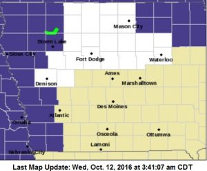
FREEZE WARNING IN EFFECT FROM 1 AM TO 9 AM CDT THURSDAY
THE NATIONAL WEATHER SERVICE IN DES MOINES EXPANDED A FREEZE
WARNING FOR THE KJAN LISTENING AREA. THE WARNING IS IN EFFECT FROM 1 AM TO 9 AM CDT THURSDAY FOR SAC-CRAWFORD-CARROLL-AUDUBON-GUTHRIE-DALLAS-CASS-ADAIR-MADISON-ADAMS-UNION-TAYLOR-RINGGOLD COUNTIES, AND FROM 1-AM UNTIL 10-AM THURSDAY FOR MONONA-HARRISON-SHELBY-POTTAWATTAMIE-MILLS-MONTGOMERY-FREMONT- PAGE COUNTIES.
* TEMPERATURE…26 TO 32.
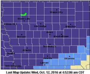
Freeze Warning for Counties in purple, Frost Advisory for those in light blue.
A FEW URBAN AREAS INCLUDING THE DES MOINES METRO MAY REMAIN ABOVE 32 HOWEVER FROST WILL OCCUR.
* IMPACTS…IN ADDITION TO THE FREEZING TEMPERATURES WIDESPREAD
FROST WILL OCCUR. SENSITIVE VEGETATION WILL NOT SURVIVE IF LEFT
UNPROTECTED.
PRECAUTIONARY/PREPAREDNESS ACTIONS…
A FREEZE WARNING MEANS SUB-FREEZING TEMPERATURES ARE IMMINENT OR HIGHLY LIKELY. THESE CONDITIONS WILL KILL CROPS AND OTHER SENSITIVE VEGETATION.
MONONA-HARRISON-SHELBY-POTTAWATTAMIE-MILLS-MONTGOMERY-FREMONT- PAGE COUNTIES; 334 AM CDT WED OCT 12 2016
A FREEZE WARNING REMAINS IN EFFECT FROM 1 AM TO 10 AM CDT THURSDAY
Freeze Warning for Counties in purple, Thursday
* TEMPERATURE…WIDESPREAD TEMPERATURES OF 32 DEGREES OR COLDER ARE LIKELY ACROSS THE AREA. THE COLDEST TEMPERATURES ARE EXPECTED TO OCCUR IN NORTHEAST NEBRASKA AND NORTHWEST IOWA… WHERE TEMPERATURES MAY FALL INTO THE MID TO UPPER 20S. TEMPERATURES MAY FALL BELOW FREEZING FOR SEVERAL HOURS.
* IMPACTS…THIS WOULD BE THE FIRST FREEZE OF AUTUMN IN MANY LOCATIONS…AND WOULD MARK THE END OF THE GROWING SEASON FOR CROPS AND SENSITIVE VEGETATION. .
PRECAUTIONARY/PREPAREDNESS ACTIONS… A FREEZE WARNING MEANS SUB-FREEZING TEMPERATURES ARE IMMINENT OR HIGHLY LIKELY. THESE CONDITIONS WILL KILL CROPS AND OTHER SENSITIVE VEGETATION.
Today: Partly cloudy & mild. High 77. S @ 10-20.
Tonight: Cloudy w/light rain developing late. Low 50. NW @ 10-20.
Tomorrow: Cldy w/shwrs. High 53. NW @ 10-30
Thursday: Mostly sunny. High around 60.
Friday: P/Cldy. High near 70.
Monday’s High in Atlantic was 66. We received .04” of an inch of rain yesterday. Our 24-hour Low (ending at 7-a.m. today) was 56. Last year on this date, our High in Atlantic was 86 and the low was 54. The Record High in Atlantic on this date was 93 in 1893. The Record Low was 17 in 1984.
DES MOINES, Iowa (AP) — This year will go down in the Iowa history books as the third wettest among 144 years of records. The Iowa Department of Natural Resources in its monthly Water Summary Update says the statewide average precipitation in Iowa was 45 inches, nearly 10 inches more than normal for the 2016 water year, which is measured from Oct. 1, 2015, through Sept. 30, 2016.
Excessive rain in September over north-central and northeast Iowa resulted in flooding and a record crest on the Shell Rock River and the second highest crest on record on the Cedar River. September rain totals varied from just under an inch at Fairfield to over 17 inches near Nora Springs.
The statewide average for the month was 6.29 inches making it the wettest September since 1986.
The Fire Danger rating in Shelby County has been lowered from “High,” to “Moderate.” Property owners and/or managers planning a controlled burn of brush or grassland areas are asked to call in and report your burning projects to Shelby County Dispatch at 712-755-2124, and notify your local Fire Chief.
Timing for burns should be morning, or evening hours and extinguished by dark unless authorized by Fire Chief due to possible impacts to roads and health from smoke. Burns must be monitored at all times.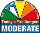
Today (Columbus Day): Increasingly cloudy scattered showers. High 70. S @ 15-30.
Tonight: Showers ending; becoming P/Cldy. Low 57. S @ 10-15.
Tomorrow: P/Cldy. High 77. S @ 10-20
Wednesday: Mostly Cloudy & cooler, w/showers likely. High 55.
Thursday: P/Cldy. High around 60.
Sunday’s High in Atlantic was 73. Our 24-hour Low (ending at 7-a.m. today) was 39. Last year on this date, our High in Atlantic was 73 and the low was 39. The Record High in Atlantic on this date was 96 in 1893. The Record Low was 17 in 1906.
EARLY THIS MORNING…PARTLY CLOUDY. SOUTH WIND NEAR 10 MPH.
TODAY…MOSTLY CLOUDY. SCATTERED SHOWERS AND ISOLATED THUNDERSTORMS IN THE AFTERNOON. BREEZY. HIGH IN THE UPPER 60S. SOUTH WIND 5 TO 15 MPH INCREASING TO 15 TO 20 MPH IN THE AFTERNOON. CHANCE OF PRECIPITATION 30 PERCENT.
TONIGHT…MOSTLY CLOUDY WITH SCATTERED LIGHT SHOWERS AND ISOLATED THUNDERSTORMS IN THE EVENING…THEN PARTLY CLOUDY OVERNIGHT. LOW IN THE LOWER 50S. SOUTH WIND 10 TO 15 MPH WITH GUSTS TO AROUND 30 MPH. CHANCE OF PRECIPITATION 30 PERCENT.
TUESDAY…MOSTLY SUNNY. HIGH IN THE MID 70S. SOUTH WIND 10 TO 15 MPH.
TUESDAY NIGHT…MOSTLY CLOUDY. A CHANCE OF LIGHT SHOWERS AND ISOLATED THUNDERSTORMS AFTER MIDNIGHT. LOW IN THE UPPER 40S. SOUTH WIND 5 TO 10 MPH SHIFTING TO THE NORTH 5 TO 15 MPH WITH GUSTS TO AROUND 25 MPH AFTER MIDNIGHT. CHANCE OF PRECIPITATION 30 PERCENT.
WEDNESDAY…CLOUDY WITH A 40 PERCENT CHANCE OF LIGHT SHOWERS IN THE MORNING…THEN MOSTLY SUNNY IN THE AFTERNOON. MUCH COOLER. HIGH IN THE MID 50S. NORTH WIND 10 TO 15 MPH WITH GUSTS TO AROUND 25 MPH.
Today: Sunny, with a high near 71. Northeast wind 5 to 9 mph becoming south in the afternoon.
Tonight: Mostly clear, with a low around 51. South wind around 7 mph.
Columbus Day: A 20 percent chance of showers and thunderstorms after 10am. Mostly cloudy, with a high near 70. Breezy, with a south wind 8 to 18 mph, with gusts as high as 30 mph.
Monday Night: A 20 percent chance of showers before 1am. Partly cloudy, with a low around 54. South wind 11 to 14 mph, with gusts as high as 25 mph.
Tuesday: Mostly sunny, with a high near 73. South wind 10 to 14 mph, with gusts as high as 20 mph.
Tuesday Night: A 30 percent chance of showers after 1am. Mostly cloudy, with a low around 47. New precipitation amounts of less than a tenth of an inch possible.
Wednesday: A 40 percent chance of showers before 1pm. Partly sunny, with a high near 54. Breezy.
Wednesday Night: Areas of frost after 5am. Otherwise, mostly clear, with a low around 32.


