
352 AM CDT TUE OCT 25 2016
EARLY THIS MORNING…MOSTLY CLOUDY. EAST WIND NEAR 10 MPH.
TODAY…MOSTLY CLOUDY. SCATTERED THUNDERSTORMS IN THE AFTERNOON. HIGH IN THE LOWER 60S. SOUTHEAST WIND 5 TO 15 MPH. GUSTS UP TO 25 MPH IN THE AFTERNOON. CHANCE OF THUNDERSTORMS 30 PERCENT.
TONIGHT…SHOWERS AND PERIODS OF THUNDERSTORMS. LOW IN THE MID 50S. SOUTH WIND 10 TO 15 MPH WITH GUSTS TO AROUND 30 MPH. CHANCE OF PRECIPITATION 90 PERCENT.
WEDNESDAY…MOSTLY CLOUDY. LIGHT SHOWERS LIKELY AND NUMEROUS THUNDERSTORMS THROUGH MID MORNING. HIGH IN THE LOWER 60S. NORTHWEST WIND 10 TO 15 MPH. CHANCE OF PRECIPITATION 60 PERCENT.
THURSDAY…MOSTLY SUNNY. HIGH IN THE MID 60S. SOUTH WIND NEAR 10 MPH.
FRIDAY…MOSTLY SUNNY. HIGH IN THE MID 70S.
Officials with the Shelby County Emergency Management Agency said today (Monday), the County Fire Danger rating will remain HIGH through Thursday, even though we are supposed to receive some moisture. Wind and continued drying after short duration moisture will keep Fire Danger in the HIGH category through Thursday. Predominate fuel at this time is grass, and will completely cure, and be ready to burn within 1 hour of rain event. 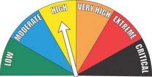
Burning of any kind is restricted unless approval is received from local Fire Chief. Controlled burns that are not reported will result in Fire Department being dispatched, and Fires extinguished if determined to be un-safe. Please call 712-755-2124 if you have any questions.
Today: Partly Cloudy. High 65. NE @ 10.
Tonight: P/Cldy. Low 45. SE @ 5-10.
Tomorrow: P/Cldy to Cldy w/scattered afternoon showers & thunderstorms. High 63. SE @ 10-20.
Wednesday: Showers ending in the morning; Becoming P/Cldy. High 65.
Thursday: P/Cldy. High 70.
Sunday’s High in Atlantic was 73. Our 24-hour Low (ending at 7-a.m. today) was 35. Last year on this date, our High in Atlantic was 61 and the low was 29. The Record High in Atlantic on this date was 82 in 1891. The Record Low was 15 in 1999.
Early This Morning: Clear. Northeast wind near 10 mph.
Today: Sunny. High in the mid 60s. East wind 5 to 10 mph.
Tonight: Partly cloudy through midnight then becoming mostly cloudy. Low in the mid 40s. Southeast wind 5 to 10 mph.
Tuesday: Cloudy. A slight chance of light showers and isolated thunderstorms in the morning…then scattered thunderstorms in the afternoon. High in the lower 60s. Southeast wind 5 to 15 mph with gusts to around 25 mph. Chance of precipitation 50 percent.
Tuesday Night: Showers and scattered thunderstorms. Low in the mid 50s. South wind 10 to 15 mph with gusts to around 30 mph. Chance of precipitation 90 percent.
Wednesday: Partly sunny. High in the mid 60s. Northwest wind 10 to 15 mph.
Wednesday Night: Partly cloudy. Colder. Low in the mid 40s.
Thursday: Mostly sunny. High in the upper 60s.
Today: Sunny, with a high near 70. Southwest wind 7 to 14 mph becoming north northwest in the morning. Winds could gust as high as 20 mph.
Tonight: Mostly clear, with a low around 39. North northwest wind 5 to 7 mph becoming northeast after midnight.
Monday: Mostly sunny, with a high near 63. East southeast wind 5 to 10 mph.
Monday Night: Increasing clouds, with a low around 47. Southeast wind 6 to 8 mph.
Tuesday: A 40 percent chance of showers and thunderstorms, mainly after 1pm. Mostly cloudy, with a high near 67. East southeast wind 8 to 15 mph, with gusts as high as 23 mph. New rainfall amounts of less than a tenth of an inch, except higher amounts possible in thunderstorms.
Tuesday Night: Showers and possibly a thunderstorm. Low around 55. Chance of precipitation is 90%. New rainfall amounts between three quarters and one inch possible.
Wednesday: Mostly cloudy, with a high near 62.
Skyscan Forecast Saturday, October 22, 2016 Richard Garuckas
Today: Mostly sunny. High 69. SW @ 5-10.
Tonight: Mostly clear. Low 44. SSE @ 5.
Sunday: Mostly sunny. High 71. S @ 5-10 becoming NW @ 10-20.
Sunday Night: Partly cloudy. Low 41.
Monday: Mostly sunny. Cooler. High 61.
Tuesday: Increasing clouds with a chance of showers. High 60.
Wednesday: Mostly cloudy with a chance of showers. High 54.

Podcast: Play in new window | Download (697.8KB)
Subscribe: RSS
Today: Areas of fog this morning; P/Cloudy. High 62. S @ 10-15.
Tonight: P/Cldy. Not as cold. Low 40. S @ 5-10.
Tomorrow: P/Cldy. High 72. SW @ 10-20.
Sunday: P/Cldy. High 72.
Monday: P/Cldy. High 65.
Thursday’s High in Atlantic was 58. Our 24-hour Low (ending at 7-a.m. today) was 30. Last year on this date, our High in Atlantic was 69 and the low was 50. The Record High in Atlantic on this date was 87 in 1947. The Record Low was 13 in 1930.
250 AM CDT FRI OCT 21 2016
EARLY THIS MORNING…CLEAR…COLDER. EAST WIND NEAR 5 MPH.
TODAY…SUNNY. HIGH AROUND 60. SOUTH WIND NEAR 10 MPH INCREASING TO 10 TO 15 MPH IN THE AFTERNOON.
TONIGHT…MOSTLY CLEAR. LOW AROUND 40. SOUTH WIND 5 TO 10 MPH.
SATURDAY…SUNNY. HIGH IN THE UPPER 60S. SOUTH WIND NEAR 10 MPH.
SUNDAY…SUNNY. HIGH AROUND 70. NORTHWEST WIND 5 TO 15 MPH.
MONDAY…SUNNY. HIGH IN THE MID 60S.
TUESDAY…MOSTLY CLOUDY. A CHANCE OF SHOWERS IN THE MORNING… THEN A CHANCE OF SHOWERS AND ISOLATED THUNDERSTORMS IN THE AFTERNOON. HIGH IN THE UPPER 60S. CHANCE OF PRECIPITATION 30 PERCENT.
ADAMS-UNION-TAYLOR-RINGGOLD COUNTIES…
A FROST ADVISORY IS IN EFFECT FROM 3 AM TO 8 AM CDT TODAY (FRIDAY).
* TEMPERATURE…32 TO 36 DEGREES INTO EARLY FRIDAY MORNING.
* IMPACTS…SENSITIVE PLANTS MAY BE DAMAGED OR KILLED IF NOT PROTECTED OR BROUGHT INDOORS.
PRECAUTIONARY/PREPAREDNESS ACTIONS… A FROST ADVISORY MEANS THAT WIDESPREAD FROST IS EXPECTED. SENSITIVE OUTDOOR PLANTS MAY BE KILLED IF LEFT UNCOVERED.
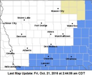
Frost Advisory for counties in light blue
The National Climate Prediction Center is again issuing a La Nina watch into next year, though an Iowa climatologist says it likely isn’t much reason for farmers and snow shovelers to worry. Dennis Todey, director of the U-S-D-A Midwest Climate Hub in Ames, says the La Nina watch won’t mean any significant changes in the long-range outlook. “Okay, yeah, it could end up being La Nina,” Todey says. “Still, I don’t think it’s going to be a major issue. It doesn’t really change too much about what it says for the winter or for next growing season.”
La Nina occurs when Pacific Ocean surface temperatures fall and it has some effect on the weather across North America. Todey says the looming La Nina may be a contributing factor to the winter ahead. “The storm pattern may be a bit more active across the northern U.S. this year,” Todey says. “I’m not saying we’re calling for more precipitation than average but it could be more active and we’ll probably see more storm systems coming through.”
Todey says other factors may have more of an effect on the weather through next spring. “Probably something else is going to kick in and be more of a driver this winter than the La Nina will be,” Todey says, “and then, it becomes a non-factor by next summer.” The La Nina pattern comes on the heels of a two-year, record-breaking El Nino pattern that faded away late this summer.
(Radio Iowa)


