
MILLS IA-CASS NE-OTOE NE-SARPY NE-
1130 AM CDT THU OCT 6 2016
…SIGNIFICANT WEATHER ADVISORY FOR WESTERN MILLS…CASS (NE)…
SOUTHWESTERN SARPY AND NORTHWESTERN OTOE COUNTIES in NE UNTIL 1215 PMCDT…
AT 1129 AM CDT…DOPPLER RADAR WAS TRACKING STRONG THUNDERSTORMS ALONG A LINE EXTENDING FROM 7 MILES NORTH OF BENNET TO 4 MILES WEST OF AVOCA. MOVEMENT WAS NORTHEAST AT 45 MPH. NICKEL SIZE HAIL WILL BE POSSIBLE WITH THESE STORMS.
LOCATIONS IMPACTED INCLUDE…
PLATTSMOUTH…LOUISVILLE…WEEPING WATER…ELMWOOD…MURRAY…
AVOCA…MURDOCK…NEHAWKA…EAGLE…MANLEY…
ALVO AND PLATTE RIVER STATE PARK.
THIS INCLUDES HIGHWAY 75 IN NEBRASKA NEAR MILE MARKER 73.
The grassland/field fire Danger rating will remain HIGH in Shelby County, until further notice. Emergency Management Coordindator Bob Seivert said Thursday (today), while some rain has fallen and more is likely, the amount of crops and vegetation in the fields is significant, and those elements can dry out in a matter of hours, creating a potential fast burning situation.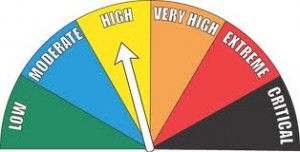
Today: Mostly cloudy w/scattered thunderstorms late this morning; Thunderstorms becoming more numerous this afternoon. Some may be severe later today. High 73. SE @ 10-20. Chance of thunderstorms 60 percent.
Tonight: Mostly cloudy w/showers & thunderstorms diminishing around midnight. Low 42. NW @ 10-20.
Friday: P/Cldy. High 62. NW @ 10-20.
Friday Night: Clear. Low around 40. Southwest wind near 5 mph.
Saturday: P/Cldy. High 68. SW @ 10-20 w/gusts to 25.
Saturday Night: Clear. Low in the mid 40s.
Sunday: Sunny. High in the lower 70s.
Wednesday’s High in Atlantic was 73. Our 24-hour Low (ending at 7-a.m. today) was 51. Last year on this date, our High in Atlantic was 73 and the low was 50. The Record High in Atlantic on this date was 91 in 1963 & 1997. The Record Low was 15 in 2012.
AREA COUNTIES: CRAWFORD-CARROLL-AUDUBON-GUTHRIE-DALLAS-CASS-ADAIR-MADISON-ADAMS-UNION-TAYLOR-RINGGOLD…
SEVERE THUNDERSTORMS ARE POSSIBLE LATE THIS AFTERNOON AND EVENING. THREATS ARE TORNADOES…DAMAGING WINDS…AND LARGE HAIL. A BRIEF PERIOD OF HEAVY RAINFALL IS ALSO POSSIBLE.
STORM SPOTTER ACTIVATION MAY BE REQUIRED ACROSS WESTERN & S.W. IA THIS AFTERNOON.
AREA COUNTIES: MONONA-HARRISON-SHELBY-POTTAWATTAMIE-MILLS-MONTGOMERY-FREMONT-PAGE…
STRONG TO SEVERE THUNDERSTORMS WILL LIKELY DEVELOP LATE THIS AFTERNOON AND CONTINUE INTO THE EARLY EVENING HOURS…MAINLY ALONG AND SOUTH OF INTERSTATE 80. DEEP LAYER WIND SHEAR COUPLED WITH STRONG INSTABILITY WILL BE IN PLACE FOR SUPERCELL DEVELOPMENT WITH LARGE HAIL AND DAMAGING WINDS THE MAIN THREATS. GIVEN THE STRONG ENVIRONMENTAL SHEAR…A FEW STORMS MAY BECOME TORNADIC IN NATURE IN EXTREME SOUTHEAST NEBRASKA AND SOUTHWEST IOWA.
Early This Morning: Partly cloudy. Northeast wind near 10 mph.
Today: Partly sunny in the morning then becoming mostly cloudy. Scattered thunderstorms in the morning…then thunderstorms likely in the afternoon. Some thunderstorms may be severe late in the afternoon. High in the lower 70s. Southeast wind 5 to 15 mph. Chance of thunderstorms 60 percent.
Tonight: Mostly cloudy until early morning then becoming partly cloudy. Thunderstorms likely through midnight…then a slight chance of showers after midnight. Colder. Some thunderstorms may be severe in the evening. Low in the lower 40s. West wind 10 to 15 mph shifting to the northwest after midnight. Gusts up to 30 mph. Chance of precipitation 70 percent.
Friday: Sunny…cooler. High around 60. Northwest wind 5 to 10 mph.
Friday Night: Clear. Low around 40. Southwest wind near 5 mph.
Saturday: Sunny. High in the upper 60s. Southwest wind near 10 mph increasing to 10 to 15 mph in the afternoon. Gusts up to 25 mph.
Saturday Night: Clear. Low in the mid 40s.
Sunday: Sunny. High in the lower 70s.
Today: Areas of fog this morning; P/Cldy. High 73. W-SE @ 10.
Tonight: P/Cldy to Cldy w/shwrs late. Low 55. SE @ 5-10.
Tomorrow: Scattered shwrs & tstrms. High 73. SE @ 10-20.
Friday: P/Cldy. High 62.
Saturday: P/Cldy. High 68.
Tuesday’s High in Atlantic was 71. We received 1.42” of rain over the past 24-hours (ending at 7-a.m. today) Our 24-hour Low was 56. Last year on this date, our High in Atlantic was 68 and the low was 44. The Record High in Atlantic on this date was 93 in 1963. The Record Low was 22 in 2012.
EARLY THIS MORNING…PARTLY CLOUDY WITH ISOLATED THUNDERSTORMS. AREAS OF FOG. SOUTHWEST WIND 5 TO 10 MPH. CHANCE OF THUNDERSTORMS 20 PERCENT.
TODAY…SUNNY. AREAS OF FOG THROUGH MID MORNING. HIGH IN THE MID 70S. WEST WIND AROUND 5 MPH SHIFTING TO THE SOUTHEAST UP TO 5 MPH IN THE AFTERNOON.
TONIGHT…PARTLY CLOUDY. A CHANCE OF SHOWERS AND ISOLATED THUNDERSTORMS OVERNIGHT. LOW IN THE MID 50S. EAST WIND NEAR 5 MPH. CHANCE OF PRECIPITATION 30 PERCENT.
THURSDAY…CLOUDY. A CHANCE OF THUNDERSTORMS IN THE MORNING… THEN THUNDERSTORMS IN THE AFTERNOON. HIGH IN THE LOWER 70S. SOUTHEAST WIND 5 TO 10 MPH. GUSTS UP TO 20 MPH IN THE AFTERNOON. CHANCE OF THUNDERSTORMS 80 PERCENT.
THURSDAY NIGHT…MOSTLY CLOUDY. THUNDERSTORMS LIKELY THROUGH MIDNIGHT. COLDER. LOW IN THE LOWER 40S. NORTHWEST WIND 10 TO 15 MPH WITH GUSTS TO AROUND 25 MPH. CHANCE OF THUNDERSTORMS 70 PERCENT.
FRIDAY…SUNNY…COOLER. HIGH IN THE LOWER 60S. NORTHWEST WIND AROUND 10 MPH. GUSTS UP TO 20 MPH IN THE MORNING.
FRIDAY NIGHT…MOSTLY CLEAR. LOW IN THE UPPER 30S.
Today: Mostly Cloudy w/scattered showers & thunderstorms. High 73. SE @ 10-20.
Tonight: Partly Cloudy to Cloudy w/showers ending. Low 57. S-W @ 10.
Tomorrow: P/Cldy to Cldy. High 72.
Thursday: Mo. Cldy w/showers & tstrms. High 72.
Friday: Isolated showers in the morning; Becoming P/Cldy. High 62.
Monday’s High in Atlantic was 77. Our 24-hour Low (ending today at 7-a.m.) was 46. Last year on this date, our High in Atlantic was 62 and the low was 36. The Record High in Atlantic on this date was 90 in 1938 & 2005. The Record Low was 20 in 1968.
345 AM CDT TUE OCT 4 2016
EARLY THIS MORNING…MOSTLY CLOUDY. WARMER. SOUTHEAST WIND 10 TO 15 MPH WITH GUSTS TO AROUND 25 MPH.
TODAY…PARTLY SUNNY. A CHANCE OF SHOWERS BEFORE NOON. THUNDERSTORMS IN THE AFTERNOON. BREEZY. HIGH IN THE MID 70S. SOUTH WIND 10 TO 20 MPH WITH GUSTS TO AROUND 30 MPH. CHANCE OF PRECIPITATION 90 PERCENT.
TONIGHT…THUNDERSTORMS THROUGH MIDNIGHT…THEN PARTLY CLOUDY WITH A CHANCE OF THUNDERSTORMS AFTER MIDNIGHT. LOW IN THE MID 50S. SOUTH WIND 5 TO 15 MPH WITH GUSTS TO AROUND 30 MPH. CHANCE OF THUNDERSTORMS NEAR 100 PERCENT.
WEDNESDAY…SUNNY. HIGH IN THE MID 70S. WEST WIND AROUND 5 MPH SHIFTING TO THE SOUTH IN THE AFTERNOON.
WEDNESDAY NIGHT…PARTLY CLOUDY THROUGH MIDNIGHT THEN BECOMING MOSTLY CLOUDY. A CHANCE OF SHOWERS AND ISOLATED THUNDERSTORMS. LOW IN THE MID 50S. EAST WIND NEAR 5 MPH. CHANCE OF PRECIPITATION 40 PERCENT.
THURSDAY…THUNDERSTORMS. HIGH IN THE LOWER 70S. EAST WIND 5 TO 15 MPH. CHANCE OF THUNDERSTORMS 90 PERCENT.
THURSDAY NIGHT…THUNDERSTORMS LIKELY THROUGH MIDNIGHT…THEN A SLIGHT CHANCE OF SHOWERS AFTER MIDNIGHT. COOLER. LOW IN THE MID 40S. CHANCE OF PRECIPITATION 70 PERCENT.
FRIDAY…PARTLY SUNNY. COOLER. HIGH IN THE UPPER 50S.


