
Today: Partly cloudy. High 70. NW @ 15-25.
Tonight: Mostly clear. Low 38.
Tomorrow: Mostly sunny. High around 70. NW @ 10.
Thursday: P/Cldy. High 74
Friday: P/Cldy. High around 80.
Monday’s High in Atlantic was 76. Our Low this morning 48. Last year on this date, the High in Atlantic was 89 and the low was 69. The Record High in Atlantic on this date was 104 in 1913. The Record Low for this date was 34 in 1962.
Labor Day (Today): Partly cloudy. NW @ 10-20. High near 80.
Tonight: P/Cldy. Low 48. NW @ 10-20 diminishing late.
Tomorrow: P/Cldy. High around 70. NW winds @ 15-25.
Wednesday: Mostly Sunny. High 68.
Thursday: P/Cldy. High 70
Sunday’s High in Atlantic was 84. Our (24-hour) Low at 7-a.m. will be 53. Last year on this date, the High in Atlantic was 79 and the low was 64. The Record High in Atlantic on this date was 101 in 1918. The Record Low for this date was 33 in 1891.
Today: Dense Fog Advisory until 10-a.m. for Cass, Adams, Audubon, Union Taylor & Ringgold Counties, otherwise sunny. High 88. S/SW @ 5-10.
Tonight: Mostly clear. Low 65. S @ 5-10.
Tomorrow/Labor Day: Sunny & breezy. High 81. W winds @ 5-15 shifting to the N & gusting to 25mph.
Monday night: P/Cldy. Low 51.
Tuesday: Sunny & breezy. High 72.
Tue. Night: Mo. Clear. Low 45.
Wednesday: Sunny. High near 70.
Saturday’s High in Atlantic was 81. Our Low this morning 55. Last year on this date, the High in Atlantic was 77 and the low was 57. The Record High in Atlantic on this date was 102in 1937. The Record Low for this date was 32 in 1974.
541 AM CDT Sun Sep 3 2017
…AREAS OF DENSE FOG SPREADING ACROSS WESTERN AND SOUTHERN IOWA…
.A clear sky, moist low level air and a light wind are all coming together to produce areas of dense fog…especially in lower lying areas. The fog is expected to dissipate fairly rapidly after sunrise.
AREA COUNTIES: Audubon-Cass-Adams-Union-Taylor-Ringgold
…DENSE FOG ADVISORY IN EFFECT UNTIL 10 AM CDT THIS MORNING…
The National Weather Service in Des Moines has issued a Dense Fog Advisory, which is in effect until 10 AM CDT this morning.
* VISIBILITY…one quarter mile or less.
* IMPACTS…Rapid reduction in visibility especially in lower lying areas will cause driving difficulties.
PRECAUTIONARY/PREPAREDNESS ACTIONS…
A Dense Fog Advisory means visibilities will frequently be reduced to less than one quarter mile. If driving, slow down, use your headlights, and leave plenty of distance ahead of you.
Skyscan Forecast Saturday, September 2, 2017 Richard Garuckas
Today: Partly to mostly sunny. S @ 5-10. Warmer. High 83.
Tonight: Mostly clear. Light and variable breeze. Low 61.
Sunday: Mostly sunny. Much warmer. High 89. SSW @ 5-10
Sunday night: Mostly clear. Low 68.
Monday: Mostly sunny. High 86.
Tuesday: Mostly sunny. Cooler. High 73.
Wednesday: Mostly sunny. High 72.

Podcast: Play in new window | Download (713.6KB)
Subscribe: RSS
The Labor Day weekend forecast calls for warm weather and sunny skies for much of Iowa — and it follows a month where the state was generally cooler and drier than usual. State climatologist Harry Hillaker says August wrapped up being unseasonably mild statewide. “Primarily, it was about 3.4-degrees cooler than normal,” Hillaker says. “We only had five days out of 31 that averaged above-normal on temperatures and none of those did it by very much.” It was the 16th coolest August in Iowa in 145 years of record-keeping as well as the coolest August since 2004.
Here in Atlantic, the average High for the month was 81. The average Low was 56. The norms are 83 and 61. As for rainfall, August was the third straight month of below-normal precipitation, but Hillaker says there was an unusual twist. “Both June and July we had drier-than-normal conditions over the southwest two-thirds of the state and then in August, it was exactly the opposite,” Hillaker says. “The driest part of the state was northeast and east-central Iowa, which had been the wettest previously, and the wetter part of the state was all the rest of Iowa, especially the far west, roughly the western third.”
The state averaged three-point-eight inches of rainfall during the month, about four-tenths of an inch below normal. Rainfall was widely varied. In Atlantic, we received 8.48 inches during the month of August, which was 4.6 inches above average.
And, while the eastern Iowa town of Muscatine recorded only half-an-inch of rain during the month, the northwestern town of Milford reported almost 11-inches. As for the month ahead, Hillaker says a long-range forecast was just issued by the National Weather Service. “They just put out a new 30-day outlook for the month of September,” Hillaker says, “and it’s going for below-normal temperatures for the month of September and also favors below-normal rainfall for that month as well.”
The Month of September, in Atlantic, usually brings us 3.81 inches of rain, an average High of 74, and an average Low of 51.
(Radio IA, w/local info. from KJAN)
Special Weather Statement for the following area counties: Sac-Crawford-Carroll-Audubon-Guthrie-Dallas-Cass-Adair-Madison-Adams-Union-Taylor-Ringgold…
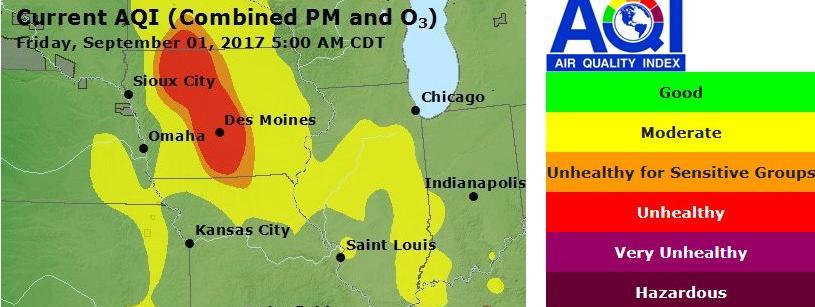
Officials with the National Weather Service in Des Moines report smoke from Canadian forest fires is moving across Iowa. National Weather Service meteorologist Dave Cousins said the fires in the Canadian provinces of Manitoba and Saskatchewan likely were supplying the majority of the smoky haze. He said also, the haze had cut visibility at the Davenport Municipal Airport to 2 1/2 miles.
In Addition, the latest Air Quality Index provided by the Iowa DNR suggests unhealthy conditions for parts of Iowa. In western Iowa, some people may experience unusual sensitivity to air pollution created by the smoke. In Central and north central Iowa, where the effects are more moderate, persons may realize more serious health effects, especially those who already have breathing issues.
Today: Areas of fog this morning, otherwise partly cloudy. High 80. SE @ 10-15.
Tonight: Cloudy w/scattered showers possible. Low 62. SE @ 5-10.
Tomorrow: Rain ending in the morning; P/Cldy. High 84. W @ 5-10.
Sunday: P/Cldy. High 88.
Monday: P/Cldy. High 86.
Thursday’s High in Atlantic was 84. Our Low this morning 54. Last year on this date, the High in Atlantic was 80 and the low was 52. The Record High in Atlantic on this date was 99 in 1913. The Record Low for this date was 34 in 1967.
Today: Areas of fog this morning; Partly Cloudy. High 81. NE @ 5-10.
Tonight: P/Cldy. Low 56. Light & variable winds.
Tomorrow: P/Cldy. High 82. SE @ 10.
Saturday: P/Cldy. High 84.
Sunday: P/Cldy. High 88.
Labor Day (Monday): P/Cldy. High near 90.
Wednesday’s High in Atlantic was 83. Our Low this morning (as of 5-a.m.) was 52. Last year on this date, the High in Atlantic was 81 and the low was 52. The Record High in Atlantic on this date was 101 in 1913. The Record Low for this date was 35 in 1967.
Today: Areas of fog this morning, otherwise partly cloudy. High 82. W @ 5-10.
Tonight: P/Cldy. Low 58. N @ 5.
Tomorrow: Partly cloudy to Cldy. High 80. NE @ 5-10.
Friday: P/Cldy. High 82.
Saturday: P/Cldy. High 84.
Tuesday’s High in Atlantic was 80. Our Low this morning (as of 5-a.m.) was 51. Last year on this date, the High in Atlantic was 80 and the low was 63. The Record High in Atlantic on this date was 101 in 1947. The Record Low for this date was 33 in 1893.


