
Counties: Monona-Harrison-Shelby-Pottawattamie-Mills-Montgomery-Fremont-Page
WIND ADVISORY IN EFFECT FROM 10 AM TO 7 PM CDT MONDAY, OCT. 23rd
Counties: Emmet-Palo Alto-Pocahontas-Sac-Calhoun-Crawford-Carroll-Audubon-Cass:
WIND ADVISORY IN EFFECT FROM 1 PM TO 7 PM CDT MONDAY, OCT, 23RD
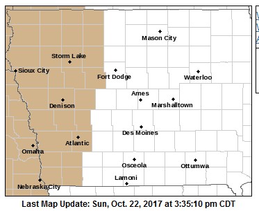
Wind Advisory counties in tan
The National Weather Service in Des Moines has issued a Wind Advisory.
* TIMING…Winds will become northwest and quite gusty by midday, continuing through sunset.
* WINDS…Northwest winds will reach sustained speeds of 25 to 35 mph with peak gusts of 40 to 45 mph. Winds will gust to near 50 mph Monday afternoon in the far west & southwest counties.
* IMPACTS…Strong northwest winds may affect high profile vehicles, blow trash cans and other loose objects and break small branches. These strong winds may also cause difficulty controlling fires with fields being harvested especially susceptible.
PRECAUTIONARY/PREPAREDNESS ACTIONS…
A Wind Advisory means that winds of 30 mph or more are expected. Winds this strong can make driving difficult, especially for high
profile vehicles. Use extra caution.
| Today: Sunny, with a high near 65. West northwest wind 5 to 10 mph. Tonight: Mostly clear, with a low around 42. South wind around 5 mph. Monday: Sunny & windy, with a high near 64. NW wind 5 to 10 mph increasing to 25 during the day, w/gusts to near 35 mph. Monday Night: Partly cloudy & windy, with a low around 40. NW @ 15-30. Tuesday: Sunny, with a high near 53. N/NW wind 20-35mph. Tuesday Night: Partly cloudy, with a low around 36. Wednesday: Mostly sunny, with a high near 64. |
448 PM CDT SAT OCT 21 2017
Significant Weather Advisory for SOUTHEASTERN PAGE COUNTY UNTIL 515 PM CDT…
At 447 PM CDT, Doppler radar was tracking a strong thunderstorm near Braddyville, or 18 miles northeast of Tarkio, moving northeast at 45 mph.
Winds of 40 to 50 mph will be possible with this storm.
Locations impacted include…
Clarinda, Braddyville, College Springs and Shambaugh.
442 PM CDT SAT OCT 21 2017
Humboldt IA-Palo Alto IA-Boone IA-Guthrie IA-Kossuth IA-Winnebago IA-
Carroll IA-Union IA-Madison IA-Hancock IA-Cass IA-Hamilton IA-
Wright IA-Audubon IA-Calhoun IA-Adams IA-Greene IA-Webster IA-
Pocahontas IA-Adair IA-Ringgold IA-Dallas IA-Taylor IA-
442 PM CDT SAT OCT 21 2017
…Strong Storms Moving across Central Iowa…
At 437 PM CDT, Doppler radar was tracking strong thunderstorms along a line extending from the Iowa Minnesota border northeast of Algona…to near Glidden to near Clarinda. The line as a whole was moving east at 25 mph, while individual storms were moving northeast along the line at 45 mph.
Up to dime sized hail and winds in excess of 40 mph will be possible with the stronger storms. Those attending or planning outdoor events should be prepared for thunderstorms and rapidly changing conditions, having shelter available on short notice.
Locations impacted include…
Fort Dodge, Waukee, Boone, Webster City, Creston, Perry, Atlantic, Algona, Winterset, Jefferson, Forest City, Adel, Garner, Clarion, Greenfield, Rockwell City, Mount Ayr, Corning, Guthrie Center and Bedford.
Skyscan Forecast Saturday, October 21, 2017 Richard Garuckas
Today: Cloudy. Showers and thunderstorms likely. S @ 15-20 gusting up to 35. High 70.
Tonight: Showers and thunderstorms early then gradual clearing. WNW @ 10-15. Low 44.
Sunday: Mostly sunny. WNW @ 5-10. High 63.
Monday: Mostly sunny. High 67.
Tuesday: Mostly sunny. Cooler and windy. High 53.
Wednesday: Mostly sunny. High 62.

Podcast: Play in new window | Download (737.4KB)
Subscribe: RSS
(UPDATE 2:50-a.m.: Warning cancelled. The storms have fallen through the level listed for SEVERE criteria.)
BULLETIN – IMMEDIATE BROADCAST REQUESTED
Severe Thunderstorm Warning
National Weather Service Omaha/Valley Nebraska
232 AM CDT SAT OCT 21 2017
The National Weather Service in Omaha has issued a
* Severe Thunderstorm Warning for…
Northwestern Shelby County in southwestern Iowa…
* Until 300 AM CDT
* At 232 AM CDT, a severe thunderstorm was located 4 miles southwest of Earling, or 20 miles south of Denison, moving northeast at 45 mph.
HAZARD…60 mph wind gusts and quarter size hail.
SOURCE…Radar indicated.
IMPACT…Hail damage to vehicles is expected. Expect wind damage to roofs, siding, and trees.
* Locations impacted include…
Earling, Defiance, Panama, Westphalia and Manteno Recreation Area. This includes Highway 59 in Iowa between mile markers 83 and 89.
PRECAUTIONARY/PREPAREDNESS ACTIONS…
For your protection move to an interior room on the lowest floor of a building.
Torrential rainfall is occurring with this storm, and may lead to flash flooding. Do not drive your vehicle through flooded roadways.
Shelby County Emergency Management Coordinator Bob Seivert today, is advising local fire chiefs in the County to place your local fire danger signs in the Extreme category, until 7-pm. The request is due to the expected high wind and dry conditions. No open burning is allowed in Shelby County today. Fires that do start will move quickly and be very difficult to contain and control. Seivert advises property owner/tenants to “Have a plan. If a fire occurs and you are in the path. You must move quickly to place of safety.” 
Today: Partly cloudy. High 78. SW @ 15-25.
Tonight: Partly cloudy to cloudy. Low 64. S @ 10-15 mph.
Saturday: Cloudy w/showers & thunderstorms. High 70. S @ 10-20.
Sunday: P/Cldy. High 67.
Monday: Mo. Cldy. High 65.
Thursday’s High in Atlantic was 77. Our 24-hour Low (at 7-a.m. today) will be/was 39. Last year on this date, the High in Atlantic was 58 and the low was 30. The Record High in Atlantic on this date was 87 in 1947 & 2003. The Record Low for this date was 14 in1960.
It’s been sunny and relatively warm with temperatures in the 60s and 70s this week, but Iowa Department of Transportation employees are busy preparing for winter. Craig Bargfrede is the DOT’s winter operations administrator. “In our world, October 15th is actually the official start of the winter season and that runs through April 15th,” Bargfrede says.
The agency’s 900 plows and other snow-moving equipment are being brought out of storage for tuneups and maintenance. “Making sure everything is functioning properly on the trucks, plows, blowers – we’re in the process of doing calibration on all of our spreaders to make sure the material is being dispensed properly and accurately across the board,” Bargfrede says. 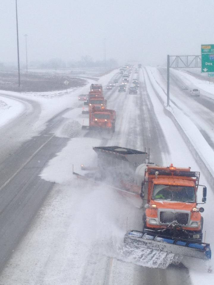
Over the summer, the Iowa DOT stocked storage facilities with nearly 230-thousand tons of salt to use on roads this winter. “Our annual usage has been somewhere around 140-to-150-thousand tons,” Bargfrede says. “So, if we would have a normal winter season, we have enough salt today to cover our requirement.”
In the coming weeks, even when it’s sunny and dry, Iowans may see DOT trucks spraying brine on roads and bridges. Bargfrede says it’s a “proactive approach.” Spraying brine on areas prone to frost prevents the formation of an icy layer, which typically occurs on cold, clear nights.
(Radio Iowa)
Today: Partly-to-Mostly Sunny. High 76. SE @ 10-15.
Tonight: Fair to Partly cloudy. Low 50. S @ 5-10 mph.
Tomorrow: P/Cldy. High 78. SW @ 15-25.
Saturday: Mo. Cldy w/showers or thunderstorms. High 70.
Sunday: P/Cldy. High 65.
Wednesday’s High in Atlantic was 74. Our Low this morning was 39. Last year on this date, the High in Atlantic was 73 and the low was 42. The Record High in Atlantic on this date was 88 in 2003. The Record Low for this date was 12 in1972.


