
Audubon-Guthrie-Cass-Adair-Adams-Union-Taylor-Ringgold-Crawford-Carroll Counties have been added to a Freeze Warning early Friday morning.
338 PM CDT Thu Oct 26 2017
…FREEZE WARNING IN EFFECT FROM 1 AM TO 9 AM CDT FRIDAY…
The National Weather Service in Des Moines has issued a Freeze
Warning, which is in effect from 1 AM to 9 AM CDT Friday.
* TEMPERATURE…Around 30 degrees.
* IMPACTS…Temperatures below freezing will kill unprotected
cold-sensitive plants.
PRECAUTIONARY/PREPAREDNESS ACTIONS…
A Freeze Warning means sub-freezing temperatures are imminent or
highly likely. These conditions will kill crops and other
sensitive vegetation.
This is in addition to Shelby-Pottawattamie-Mills-Montgomery-Fremont-Page-Harrison counties which have a Freeze Warning in place from 5:00am-9:00am Friday morning.
Today: Partly cloudy. High 61. S-NW @ 10-20.
Tonight: Partly cloudy. Low 34. NW @ 15-30mph.
Tomorrow: Mostly Cloudy w/sprinkles or flurries possible. High 40. NW @ 20-40.
Saturday: P/Cldy. High 44.
Sunday: P/Cldy & warmer. High 60.
Wednesday’s High in Atlantic was 69. Our 24-hour Low (ending at 7-a.m. today) will be 40. (As of 5:15-a.m. today, it was 51) Last year on this date, the High in Atlantic was 64 and the low was 37. The Record High in Atlantic on this date was 84 in 1956. The Record Low for this date was 14 in1980.
The National Weather Service in Omaha has issued WIND ADVISORY in effect from 10-a.m. today (Thursday) until 7-p.m. for Harrison, Pottawattamie, and Shelby Counties, and from 10-a.m. today until 10-p.m., for Monona County.
A FREEZE WARNING is now in effect from 5-a.m. Friday until 9-a.m. Friday, for Harrison, Pottawattamie, Shelby, Mills, Montgomery, Fremont and Page Counties.
The Freeze Watch issued Wednesday afternoon, was cancelled and replaced by the Freeze Warning.
* TIMING…Strong northwest winds expected around noon today and continuing through the afternoon. Freezing temperatures expected Friday morning.
* WINDS…Northwest increasing to 30 to 35 mph with gusts 40 to 45 mph.
* TEMPERATURE…At or below freezing Friday morning.
* IMPACTS…Cold temperatures will result in a killing freeze ending the growing season this year.
PRECAUTIONARY/PREPAREDNESS ACTIONS…
A Freeze Warning means sub-freezing temperatures are imminent or highly likely. These conditions will kill crops and other sensitive vegetation.
A Wind Advisory means that winds of 30 to 39 mph are expected for one hour or longer, or winds of 45 to 57 mph for any duration. Winds this strong can make driving difficult, especially for high profile vehicles. Use extra caution.
The National Weather Service in Omaha has issued a WIND ADVISORY for Harrison County from 10-a.m. Thursday until 7-p.m., and from 10-a.m. Thursday until 10-p.m., for Monona County. Winds are expected to be out of the northwest from 30-to as much as 50-mph during the Advisory time frames.
Winds this strong can make driving difficult, especially for high profile vehicles. Use extra caution.
The National Weather Service in Omaha has issued a FREEZE WATCH for Shelby and Harrison Counties, from 5-a.m. Friday to 9-a.m., and from 1-a.m until 10-a.m. Saturday; a FREEZE WATCH is also in effect from 1-a.m. Saturday until 10-a.m. for Pottawattamie, Mills-Montgomery-Fremont and Page Counties.
* TEMPERATURE…Around freezing Friday morning, then in the mid-20s Saturday morning.
* IMPACTS…Cold temperatures will result in a killing freeze ending the growing season this year.
PRECAUTIONARY/PREPAREDNESS ACTIONS…
A Freeze Watch means sub-freezing temperatures are possible. These conditions could kill crops and other sensitive vegetation.
Today: Mostly sunny & warmer. High 70. W @ 10-20.
Tonight: Partly cloudy. Low 46. S @ 5-10mph.
Tomorrow: P/Cloudy. High 60. NW @ 10-20.
Friday: Mo. Cldy w/sprinkles or flurries possible. High 40.
Saturday: Mostly Cloudy. High 42.
Tuesday’s High in Atlantic was 54. Our 24-hour Low (ending at 7-a.m. today) will be 38. (As of 6:30-a.m. it was 45) Last year on this date, the High in Atlantic was 66 and the low was 49. The Record High in Atlantic on this date was 85 in 1891 & 1940. The Record Low for this date was 14 in1892.
Today: **Wind Advisory through 6-p.m; Partly cloudy. High 54. NW @ 20-35mph w/gusts to near 50.
Tonight: Partly cloudy. Low 34. W @ 5-10mph.
Tomorrow: P/Cloudy. High 70. W @ 10-20.
Thursday: P/Cldy. High 60.
Friday: Mostly Cloudy. High 45.
Monday’s High in Atlantic was 64. Our Low this morning was 40. Last year on this date, the High in Atlantic was 64 and the low was 35. The Record High in Atlantic on this date was 82 in 1891. The Record Low for this date was 15 in1999.
The National Weather Service in Omaha and Des Moines have issued Wind Advisories, which are in effect until 4-p.m. for the far west and southwest counties, and until 6-p.m. for Cass and other area counties in western/central Iowa.
Northwest winds will be from 25 to 35 mph, with sustained gusts to 50 mph and higher at times.
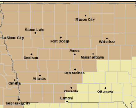
Wind Advisory until late Tuesday afternoon for counties in light brown.
Winds will cause difficulty controlling any fires that ignite, such as in fields where harvest operations are in progress. High-profile vehicles may experience hazardous travel. Loose outdoor objects may blow around in the wind.
PRECAUTIONARY/PREPAREDNESS ACTIONS…
A Wind Advisory means that winds of 30 to 39 mph are expected for an hour or more, or wind gusts of 45 to 57 mph for any duration. Winds this strong can make driving difficult, especially for high profile vehicles. Use extra caution.
Today: **Wind Advisory from mid-morning through 7-p.m.; Partly cloudy. High 67. NW @ 15-30+.
Tonight: Partly cloudy. Low 37. NW @ 15-25 mph.
Tomorrow: P/Cloudy. High 54. NW @ 15-30.
Wednesday: P/Cldy. High 70.
Thursday: P/Cldy & windy. High 55.
Sunday’s High in Atlantic was 69. Our 24-hour 24 Low this morning was 53. Last year on this date, the High in Atlantic was 73 and the low was 35. The Record High in Atlantic on this date was 81 in 1901 & 1991. The Record Low for this date was 13 in1895.
Monona-Harrison-Shelby-Pottawattamie-Mills-Montgomery-Fremont-
Page Counties: A WIND ADVISORY REMAINS IN EFFECT FROM 10-a.m. today until 7-p.m. (10/23/17)
* TIMING…Monday late morning through afternoon
* WINDS…Northwest winds 25 to 35 mph, with gusts of 40 to 50 mph or greater.
* IMPACTS…Winds would cause difficulty controlling any fires that ignite outdoors, such as in harvesting fields. High-profile vehicles may experience hazardous travel. Loose objects may blow in the wind.
Sac-Calhoun-Crawford-Carroll-Audubon-Cass Counties:
A WIND ADVISORY REMAINS IN EFFECT FROM 1-p.m. today until 7-p.m..
* TIMING…Winds will become northwest and quite gusty by midday, continuing through sunset.
* WINDS…Northwest winds will reach sustained speeds of 25 to 35 mph with peak gusts of 40 to 45 mph.
* IMPACTS…Strong northwest winds may affect high profile vehicles, blow trash cans and other loose objects and break small branches. These strong winds may also cause difficulty controlling fires with fields being harvested especially susceptible.
PRECAUTIONARY/PREPAREDNESS ACTIONS…
A Wind Advisory means that winds of 30 mph or more are expected. Winds this strong can make driving difficult, especially for high profile vehicles. Use extra caution.


