
Monona-Harrison-Shelby-Pottawattamie-Mills-Montgomery-Fremont-
Page Counties…
…SIGNIFICANT WEATHER ALERT FOR LIGHT FREEZING DRIZZLE…
Patchy light freezing drizzle is occurring this afternoon over parts of east central Nebraska into western Iowa, mixing in with snow flurries. Even very light icing can cause hazardous roads and walkways. Please drive cautiously in the area through early afternoon. People should monitor the weather situation closely. Be prepared for rapidly changing road conditions.
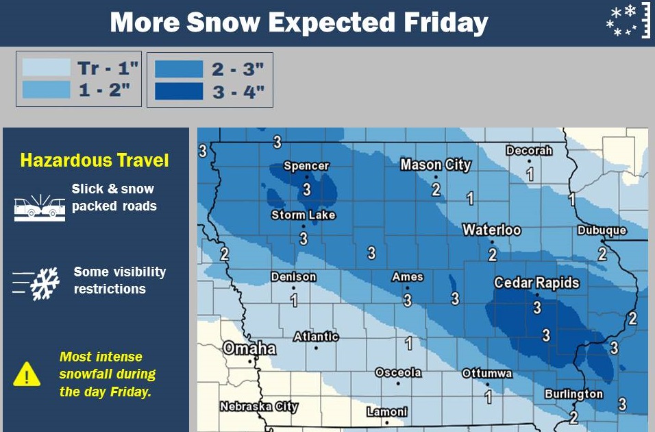
The forecast for the holiday weekend ahead likely isn’t one which the state tourism folks will tout to lure visitors to consider Iowa as a vacation destination. Besides the latest round of snow, it’ll be dangerously cold, with wind chill indices likely reaching the 40s-below zero in some areas. Meteorologist Allan Curtis, at the National Weather Service, says the flakes are flying and much of Iowa will have new snowfall soon. “We are looking at snow and there’s a fair chunk of the state that’s already seeing light-to-moderate snow, generally northwest and north-central Iowa,” Curtis says. “That’s going to continue to spread southeast through the day and on south. The heaviest bands are going to be north of the Des Moines area, up towards Waterloo and over towards Tama.”
One of the forecast maps shows the Cedar Rapids-Iowa City corridor may be getting six inches of snow by tonight (Friday). “That would be likely on the high side at this point,” Curtis says. “We’re not going to rule that out by any stretch for some local amounts. The majority of people are going to be in the three-to-four range and we will probably see a handful of four-to-five and if we do see a six-inch amount, that’s certainly not out of the question.”
It’s been bitter cold all week, but the forecast calls for the situation only to get worse for the next three to four days, just in time for the three-day holiday. “Today’s going to be the warmest day through the new year,” Curtis says. “Saturday, Sunday, Monday, we’re looking at highs below zero across pretty much the entire state and if that wasn’t bad enough, we’re also talking some absolutely brutal wind chills, especially come Saturday.”
It appears the final days of the year will also be among the very coldest. “Parts of northern Iowa are looking at easily negative-30 degrees in the morning, approaching negative-40 possibly,” Curtis says, “and on south through the state, at least negative-20 at times.” Temperatures should warm slightly by Tuesday or Wednesday, he says, with highs at least climbing into the teens above zero.
(Radio Iowa)
(AP) — As a deep freeze sets in across half the country, officials are urging people to help those most vulnerable, especially the homeless and the elderly. Forecasters are warning people to be wary of hypothermia and frostbite from the arctic blast that’s gripping a large swath from the Midwest to the Northeast.
The prolonged, dangerous cold weather has sent advocates for the homeless scrambling to get people off the streets and to bring in extra beds for them. Health officials say older people are at increased risk from such severe cold, from medication side effects to falling risks. They encouraged people to check on family members, friends and neighbors.
Animal advocates are urging people to remember their pets and not to leave them outside.
Today: Mo. Cloudy w/light snow (< 1”). High around 18. E-N @ 10.
Tonight: A chance of flurries, otherwise P/Cldy to Cldy. Low -5. N @15-25. WC as low as -20.
Tomorrow: P/Cldy to Cldy. High near 2. N @ 15-25. Wind chil as low as -25.
Saturday night: A 50% chance of snow (mainly before midnight) (less than 1/2”). Low -13. WC -25
Sunday: P/Cldy. High -3.
Sunday night: Mo. Clear. Low -23.
Monday: P/Cldy. High 3.
Thursday’s High in Atlantic was 19. Our 24-hour Low (ending at 7-a.m. Today) will be/was 3. (At 5:20-a.m., it was 12 degrees above zero). We received a trace of snowfall yesterday after 7-a.m., just a little more than a “dusting”. Last year on this date our High was 42 and the Low was 16. The all-time record High in Atlantic on this date was 60 in 1984, and the Low was -22 in 1917.
The National Weather Service in Des Moines reports, ahead of the cold outbreak this weekend, a weather system will pass across the area and bring light to moderate snow to much of the state. There will be a narrow corridor extending from northwest Iowa to east central and southeast Iowa where 1 to 3 inches will be possible. A few spots may receive up to 4 inches within the band of snow. With the passage of this system an arctic high will move into the region and bring bitterly cold air into Iowa.
Today: Cloudy to P/Cldy. High around 20. SE @ 10-20. Wind Chill as low as -5.
Tonight: P/Cldy to Cldy. Low 8. NW @ 5. WC -5.
Tomorrow: Mo. Cldy w/light snow. High near 15. N @ 10-15. Wind chil as low as -5.
Saturday: Mo. Cldy. High 4.
Sunday: P/Cldy. High 0.
Wednesday’s High in Atlantic was 7. Our 24-hour Low (ending at 7-a.m. Today) will be/was -16. (At 5:30-a.m. It was 7 degrees above zero). We received 1.6 inches of snow overnight (Liquid value .06″). Last year on this date our High was 46 and the Low was 31. The all-time record High in Atlantic on this date was 65 in 1984, and the Low was -25 in 1924.
Cass-Adair-Adams-Audubon-Guthrie-Dallas-Madison-Union-Sac-Crawford-Carroll Counties…..Light Snow to Impact Travel Tonight…
A band of light snow is anticipated to develop over west central Iowa shortly after 6 PM this evening and looks to spread east during the rest of the evening hours. The snow band will likely impact Ames to Des Moines areas by around 8 to 9 PM tonight.
The light and fluffy nature of the snow combined with winds of 10 to 20 mph will cause some slick roads and visibility restrictions at times. Interstate 80 from Atlantic to Des Moines, Interstate 35 from Osceola through Des Moines, Ankeny, Ames and as far north as Williams can expected tricky travel late tonight.
Other locations also include Highway 20 west of Interstate 35 and Highway 71 south of Sac City to around Audubon. Please use caution while driving in snowy conditions and provide plenty of space between you and the vehicle in front of you.
The steep drop in temperatures has exposed a lot of issues with furnaces that are now running constantly. West Des Moines Fire Marshal, Mike Whitsel, says his department noticed it right away when the cold snap hit.”We have seen an uptick in calls for furnaces that may catch on fire or have mechanical issues,” Whitsel says. Whitsel says it seems the earlier mild temperatures made people forget about having their furnaces tuned up. “A lot of people seemed to have delayed their annual service on those because we were in the 50s all the way up until about a week ago,” according to Whitsel. “So if there is a mechanical issue with them, now we are seeing these things are starting to run very frequently due to the cold weather. we’ve see several of them where maybe belts go bad or there is a mechanical issue that has caused the house to fill with smoke or small fires.”
He says a fireplace can be also be dangerous if you have not maintained it throughout the year. Whitsel says, “Never use your fireplace unless you have maintained that woodburning fireplace routinely and to what the experts say.” Many people are turning to space heaters to supplement their furnace. He says that’s okay as long as you take precautions. “There are good space heaters and there also some that aren’t really good to use in the home,” Whitsel says. He says you need to get a space heater that is listed by a company such as U-L. Get one that is cool to the touch and will shut off automatically when it falls over. Also be sure the heater is plugged into an outlet that can handle it. “If you use a space heater and it keeps tripping a breaker, that means that that outlet you have chosen is not compatible with the amount of draw that the space heater is using. So, be very careful of that,” Whitsel says.
Whitsel says take some time to learn the best way to use the space heater. “Whenever you open up a brand new box if you buy a new space heater — always look at the manufacturers instructions for what they recommend on how to use it,” Whitsel explains. He says space heaters need their space to prevent fires. Keep the areas around space heaters clear so there is nothing near them that can catch fire and they can effectively heat.
(Radio Iowa)
* WHAT…Very cold wind chills expected. The cold wind chills may cause frostbite in as little as 30 minutes to exposed skin. Expect wind chills to range from 15 below zero to 30 below zero.
* WHERE…All of Iowa.
* WHEN…Now to 10 AM this morning.
PRECAUTIONARY/PREPAREDNESS ACTIONS…
A Wind Chill Advisory means that cold air and the wind will combine to create low wind chills. Frost bite and hypothermia can occur if precautions are not taken. Make sure you wear a hat and gloves.
**WIND CHILL ADVISORY until 10-a.m.**
Today: Partly cloudy. High around 11. SE @ 5-10. Wind Chill as low as -25.
Tonight: Mostly cloudy w/a 60% chance of snow (Less than 1”). Low 6. SE @ 10. WC -10.
Tomorrow: P/Cldy to cldy. High near 20. S @ 10-15. Wind chil as low as -5.
Friday: Mo. Cldy w/a 30% chance of snow. High 15.
Saturday: Mo. Cldy. High 5.
Tuesday’s High in Atlantic was 8. Our Low this morning was -16. Last year on this date our High was 45 and the Low was 24. The all-time record High in Atlantic on this date was 65 in 1946, and the Low was -21 in 1924.


