
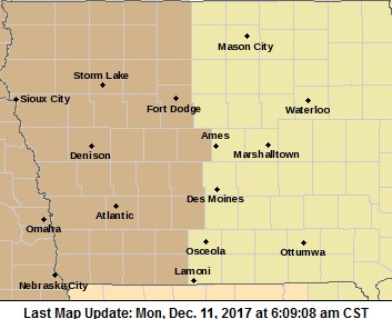
The National Weather Service has issued a WIND ADVISORY in effect from 10-a.m. today until 6-p.m. for the western-half of Iowa, including the entire KJAN listening area.
* TIMING…Winds increase past 10 am this morning and persist through the afternoon before decreasing shortly before sunset.
* WINDS…Northwest winds of 25 to 35 mph with gusts to near 45 mph.
* IMPACTS…High profile vehicles are likely to be especially affected today with the strong winds. This will result in difficult travel, particularly if needing to pass large trucks. Lightweight and unsecured objects, such as holiday decorations, maybe blown around today.
 PRECAUTIONARY/PREPAREDNESS ACTIONS…
A Wind Advisory means that sustained winds of 30 mph or wind gusts of 45 mph or greater are expected. Winds this strong can make driving difficult, especially for high profile vehicles. Use extra caution.
Today: Partly to mostly cloudy. High 45 NW @ 20-35.
Tonight: Mostly cloudy w/flurries. Low 20. NW @ 20-30.
Tomorrow: P/Cldy. NW @ 10-20. High 35
Wednesday: Mo. Cldy. High around 42.
Thursday: Mo. Cldy. High 35.
Sunday’s High in Atlantic was 50. Our 24-hour Low (at 7-a.m.) will be 25 (At 5:40-a.m. it was 34). Last year on this date, the High in Atlantic was 35 and the low was 7. The Record High in Atlantic on this date was 64 in 1965. The Record Low for this date was -14 in 1917.
Today: Partly cloudy. High 32 N-NW @ 10-25.
Tonight: Mostly clear. Low 25. SW @ 5-10.
Tomorrow: Mostly sunny. High 47. W @ 10-25.
Tom. Night: P/Cldy. Low 27.
Monday: P/Cldy. High around 45.
Tuesday: Mo. Sunny. High 34.
Friday’s High in Atlantic was 40. Our 24-hour Low (at 7-a.m.) will be 19 (At 5:40-a.m. it was 25). Last year on this date, the High in Atlantic was 22 and the low was 4. The Record High in Atlantic on this date was 62 in 1946. The Record Low for this date was -17 in 1917 & 2005.
Today: Partly cloudy to cloudy w/flurries this morning. High around 36 SW-NW @ 10-20.
Tonight: Partly cloudy to cloudy w/flurries. Low 20. NW @ 10-20.
Tomorrow: P/Cldy. High 34. NW @ 10-20.
Sunday: P/Cldy. High around 49.
Monday: Mostly Cloudy. High near 41.
Thursday’s High in Atlantic was 26. Our 24-hour Low (at 7-a.m. today) will be 11 (At 5:20-a.m. it was 21). Last year on this date, the High in Atlantic was 24 and the low was 4. The Record High in Atlantic on this date was 67 in 1946. The Record Low for this date was -18 in 1917 & 1976.
Today: Mostly sunny & breezy. High around 29. NW @ 10-20.
Tonight: Partly to cloudy. Low 16. W @ 5-10.
Tomorrow: P/Cldy to Cldy. High 35. W @ 10-20.
Saturday: P/Cldy. High around 35.
Sunday: P/Cldy to Cldy & windy. High near 50.
Wednesday’s High in Atlantic was 41. Our Low this morning (as of 5:45-a.m.) was 13.We received a trace of snow yesterday in Atlantic, as well. Last year on this date, the High in Atlantic was 25 and the low was 10. The Record High in Atlantic on this date was 64 in 1894. The Record Low for this date was -15 in 2005.
Today: P/Cldy to Cldy w/flurries possible. High around 36. NW @ 15-25.
Tonight: P/Cldy w/diminishing winds. Low 14.
Tomorrow: Mo. Sunny. High 30. NW @ 10-15.
Friday/Saturday: P/Cldy to Cldy. High both days around 35.
Wednesday’s High in Atlantic was 39. Our 24-hour Low (at 7-a.m.) will be 23 (it was 28 degrees at 5:30-a.m.) Last year on this date, the High in Atlantic was 32 and the low was 15. The Record High in Atlantic on this date was 69 in 1939. The Record Low for this date was -12 in 2005.
Today: Mostly sunny & windy. High around 37. NW @ 20-35.
Tonight: P/Cldy to Cldy w/flurries late. Low 27. NW @ 10-20.
Tomorrow: Flurries early; Mo. Cldy. High 34. NW @ 15-25.
Thursday: Mo. Sunny. High near 25.
Friday: Cldy w/a chance of flurries. High around 32.
Tuesday’s High in Atlantic was 65. Our Low this morning was 22 (as of 6:25-a.m.) Last year on this date, the High in Atlantic was 51 and the low was 23. The Record High in Atlantic on this date was 66 in 2001. The Record Low for this date was -14 in 2005.
A colder, snowier winter may be ahead for Iowa and much of the region, as most weather watchers now agree that a La Nina weather pattern has developed. Meteorologist Dennis Todey, director of the U-S-D-A’s Midwest Climate Hub, based in Ames, says the indications for La Nina conditions are steady and the pattern may last another three months or more. “We have about a 65% chance of it persisting through winter which is fairly good from a climate perspective,” Todey says. “The expectations are, typical La Nina conditions are what are reflected in the outlooks. The Northern Plains has a little better chance of being colder than average and potential for wetter than average conditions.”
A La Nina occurs when Pacific Ocean surface temperatures trend below normal for several months. Todey says this La Nina pattern appears to be only moderate in force. “This is not going to be a really strong La Nina so our outlooks don’t reflect a real strength,” Todey says, “but at least when we have a La Nina, we have a little better chance of being able to say what we’re seeing going through the wintertime.” This weather pattern usually brings certain conditions, namely more colder temperatures and more snow than usual. “If you like snow, we have a little better chance of having some snow on the ground but there’s not a ton of confidence behind this that it’s going to be exactly like this,” Todey says, “but with the La Nina, we have a little better chance of saying that it will be like this.”
He adds, the expectation is that the La Nina will fade rather quickly next spring.
(Radio Iowa)
State Climatologist Harry Hillaker says the month of November ended up a dry one in all aspects of weather records. “Every reporting point was less precipitation than usual — especially the further northwest and west the you get in the state,” Hillaker says. “Some areas, especially in northwestern Iowa didn’t have any rain whatsoever. Places like Holstein in Ida County, Washta in Cherokee County were a whopping zero for the monthly total.” Hillaker says it was just the eighth month in 131 years of records where the state averaged just a trace of snow. “Maquoketa had actually the most snow measured during the month — just three-tenths of an inch was all. Certainly most areas didn’t have any accumulation at all,” According to Hillaker. “The statewide average was just a trace of snow and typically we’d get three to four inches of snow during the month of November.”
He says drier and warmer conditions were part of the reason for the lack of snow. “Especially the second half of the month being unusually warm were it really wasn’t cold enough for snow very often and the second half of the month was very very dry. We really didn’t have much of any precipitation after the 18th — so quite a dry finish to what was a pretty dry month anyway,” Hillaker says. Hillaker says it was one of the driest months in a decade. “Overall a state average of 43-hundredths of an inch of moisture for the month, which is about 20 percent of what is usual. And actually the driest of any calendar month going back to November of 2007,” Hillaker says.
Last November was the second warmest on record, but and he things started out cold before finishing off with record warmth.”Statewide average being 36-point-two degrees, or just four-tenths of a degree colder than normal,” Hillaker says. “So in other words, the colder first half just barely canceling out the warmer second half of the month. So, things were backwards there as you usually expect the beginning of month to be warmer than the end. But this year is the other way around.”
Hillaker says one day stood out for its warmth. He says the most unusual day was the day after Thanksgiving on the 24th, where most of the state set daily record highs in the upper 60s to lower 70s. Iowa City had the warmest temperature of 74 degrees. Hillaker says you probably are noticing your heating bills for the month were up quite a bit from last year as the temperatures returned to normal after the record warm month last year.
Today: Partly to mostly cloudy & windy w/scattered light rain or drizzle. High around 64 this morning, w/temps falling into the 40’s this afternoon. There is a Wind Advisory in effect for parts of the listening area beginning at 11-a.m. in the west, and 3-p.m. for Cass & other Counties. S @ 10-20 this morning, becoming NW @ 20-35 this afternoon.
Tonight: P/Cldy to Cldy w/scattered flurries. Low 22. NW @ 20-35.
Tomorrow: P/Cldy. High 35. NW @ 15-30.
Wednesday: Mo. Cldy w/flurries. High 34.
Thursday: P/Cldy. High 29.
Our 24-Hour High in Atlantic was 64. That broke the old record of 63 set in 1962 & 2012 The Low was 23. Last Year on this date, we topped at 40 and bottomed-out at 31. The All time record high in At;antic on Dec. 4th, was 66 in 1998. The record Low for this date was -8 in 1905. Sunrise is at 7:29-a.m. and Sunset at 4:50-p.m.


