
Today: Mostly cloudy, with a high near 29. North wind 8 to 10 mph.
Tonight: Mostly cloudy, with a low around 13. Wind chill values as low as zero. North wind 8 to 10 mph.
Monday: Sunny, with a high near 26. Wind chill values as low as zero. Northwest wind 5 to 8 mph.
Monday Night: Mostly clear, with a low around 14. Wind chill values as low as 5. Calm wind becoming south southeast around 6 mph after midnight.
Tuesday: Partly sunny, with a high near 39. Breezy, with a south southeast wind 7 to 12 mph increasing to 15 to 20 mph in the afternoon. Winds could gust as high as 31 mph.
Wednesday: Partly sunny, with a high near 44.
Thursday: Partly sunny, with a high near 23.
Saturday’s High in Atlantic was 50. Our Low this morning (as of 6-a.m.), was 22. Last year on this date, the High in Atlantic was 35 and the Low was 22. The All-time record High in Atlantic on this date, was 58 in 1931 & 2015. The Record Low was -23 in 1915.
Today: Mostly sunny. High around 50. SW @ 10-15 w/gusts to around 20.
Tonight: P/Cldy. Low 24. W @ 5-10.
Tomorrow: Mostly cloudy w/a 20% chance of snow. High near 29. N @ 5-10.
Sunday Night: P/Cldy. Low 10.
Monday: Mostly sunny. High 30.
Tuesday: Partly sunny. High 41.
Friday’s High in Atlantic was 54 Our Low this morning (as of 5-a.m. Was 28). Last year on this date our High was 34 and the Low was 10. The record High in Atlantic on this date was 61 in 1934, and the Low was -31 in 1902.
1053 AM CST Fri Jan 26 2018 …WIND ADVISORY IN EFFECT UNTIL 4 PM CST THIS AFTERNOON…
The National Weather Service has issued a Wind Advisory, which is in effect until 4 PM CST this afternoon for all counties along Interstate 80 (both north and south of the Interstate) with the exception of Harrison County.
Sustained wind speeds will be from 20 to 30 mph but wind gusts will reach 45 mph. Strong wind gusts will make driving difficult, especially for high profile vehicles.
A Wind Advisory means that sustained winds of 30 mph or wind gusts of 45 mph or greater are expected. Winds this strong can make driving difficult, especially for high profile vehicles. Use extra caution.
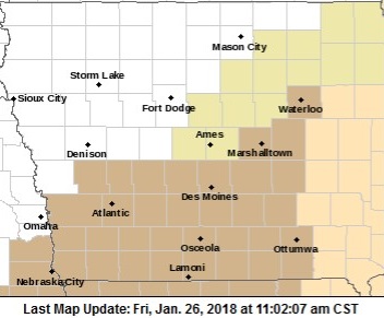
Wind Advisory for Counties in brown until 4-p.m.
The leaders of at least three Iowa cities are in the nation’s capitol for the U-S Conference of Mayors. The mayors of Davenport, Des Moines and Dubuque are attending the event. Dubuque Mayor Roy Buol says one primary focus of discussion is about the Trump administration proposal to create jobs and improve our communities through a massive road and bridge construction proposition. “We’re hopeful that this year, there’ll be some real action taken on that,” Buol says. “It’s a $5-trillion deferred need so we’re looking, hopefully, at some significant dollars that’ll be put into infrastructure.”
Along with infrastructure improvements comes the need to be best prepared for severe weather issues, having everything from storm sewers to floodwalls in top working order. “Climate change is a major concern for every mayor and council in this country,” Buol says, and that’s another key topic being addressed. “Depending on where you are, the effects are different, but especially in coastal cities where we’re having hurricanes and sea rise and flooding from rain events across the country,” he says, “just catastrophic weather situations.”
The Trump administration lashed out at so-called sanctuary cities this week, communities that vow to protect undocumented immigrants from being deported. Federal officials are seeking documentation on whether local police and sheriff’s departments are hiding actions from U-S immigration officials — which is against the law. Buol says Dubuque is trying to show itself as a “welcoming community.” “We’re definitely not going to be doing anything illegal but we’re trying to make a community of choice,” Buol says. “When you look at immigration from a city position, it’s really something that is critical to the future success, not only of Dubuque, Iowa, but of every city in this country.”
He says it’s no coincidence that immigration is a hot-button issue at the same time communities across the country are struggling to find workers as thousands of jobs are going unfilled. “One of the ways that is going to be remediated is through immigration,” he says. “People come to this country, like they always have, that have skills and education and they’re looking for a better life. They’re the people cities are looking to to help fill these jobs.”
The summit opened in Washington D-C on Wednesday and concludes later today. Buol is among 250 mayors from across the country at the conference.
(Radio Iowa)
Today: Partly Cloudy. High 53. SW-NW @ 10-20.
Tonight: P/Cldy. Low 25. NW @ 5-10.
Tomorrow: P/Cldy. High near 44. NW @ 10-20.
Sunday: P/Cldy. High near 33.
Monday: P/Cldy. High 30.
Thursday’s High in Atlantic was 49 Our Low this morning was 17. Last year on this date our High was 27 and the Low was 12. The record High in Atlantic on this date was 67 in 2002, and the Low was -24 in 1963.
Today: Areas of fog possible this morning; Becoming P/Cldy. High 50. SW @ 15-25.
Tonight: P/Cldy. Low 34. SW @ 10-15.
Tomorrow: P/Cldy. High near 52. SW-NW @ 10-20.
Saturday: P/Cldy. High near 44.
Sunday: Mostly Cloudy. High 36.
Wednesday’s High in Atlantic was 35 Our Low this morning was 19. Last year on this date our High was 31 and the Low was 23. The record High in Atlantic on this date was 65 in 1944, and the Low was -28 in 1894.
340 AM CST Thu Jan 25 2018
…DENSE FOG ADVISORY IS CANCELLED…
The National Weather Service in Des Moines has cancelled the Dense Fog Advisory issued Wednesday evening for Cass and area Counties. Patchy fog will continue through mid morning, however widespread dense fog is not expected at this point. Therefore, the advisory has been cancelled.
Dense fog has developed across portions of west central Iowa this evening and is expected to spread into northwest to north central Iowa during the late evening hours and persist through much of Thursday morning.
Audubon-Cass Counties…
…DENSE FOG ADVISORY IN EFFECT UNTIL 9 AM CST THURSDAY…
* VISIBILITY…Visibility restrictions of one quarter mile or less at times are likely.
* IMPACTS…Travel could be challenging at times due to the significantly reduced visibility. In addition to the dense fog, there is the possibility of slick spots on roadways, bridges and sidewalks from freezing moisture deposits from the
dense fog.
Shelby & Pottawattamie Counties…Areas of fog will be possible this evening, and it could be dense in some areas with visibility down to 1/2 mile or less. With temperatures at freezing and falling, slippery road conditions could develop through the evening. Travelers along Interstate 80 will encounter the fog east of the Minden area.
PRECAUTIONARY/PREPAREDNESS ACTIONS…
A Dense Fog Advisory means visibilities will frequently be reduced to less than one quarter mile. If driving, slow down, use low beam headlights, and leave plenty of distance ahead of you.
750 AM CST Wed Jan 24 2018
…AREAS OF DENSE FOG NEAR THE MISSOURI RIVER…
Dense fog dropping visibilities to a quarter mile or less had developed in and area 5 miles or so east and west of the Missouri River from Sioux City down to Omaha.
Motorists should be aware of rapid fluctuations in visibilities while driving this morning. And with temperatures in the teens, the dense fog may freeze on roads causing slippery conditions.
Today: Areas of fog and clouds this morning; Becoming P/Sunny. High 37. SW winds @ 5-10 .
Tonight: Fair to P/Cldy. Low 23.
Tomorrow: P/Cldy & windy. High near 52. SW @ 15-30.
Friday: P/Cldy. High near 50.
Saturday: P/Cldy. High 44.
Tuesday’s High in Atlantic was 27 Our Low through 5-a.m. today, was 13. Last year on this date our High was 34 and the Low was 29. The record High in Atlantic on this date was 66 in 1981, and the Low was -24 in 1894.


