
The National Weather Service has issued a Winter Weather Advisory for parts of the KJAN listening area, effective from 9-p.m. Thursday to 9-a.m. Friday. The Advisory includes Crawford-Carroll-and Dallas Counties in our area. –
Total snow accumulations of 2 to 5 inches are expected.
Plan on slippery road conditions including during the Friday morning commute. Be prepared for reduced visibilities and hazardous travel conditions at times. Take it
slow in the snow!.
A Winter Weather Advisory for snow means periods of snow will cause primarily travel difficulties. Be prepared for snow covered roads and limited visibilities, and use caution while driving. The latest road conditions for the state you are calling from can
be obtained by calling 5 1 1.
Today: P/Cloudy. High 20. W/NW @ 10-15.
Tonight: Cloudy. Low 8. V @ 5-10.
Tomorrow: Mo. Cloudy w/flurries. High 28. SE @ 10-15.
Friday: Cloudy w/snow, especially in the morning. High 22.
Saturday: Mo. Cloudy w/light snow. High 18.
Tuesday’s High in Atlantic was 10. We received .1” snow yesterday. Our 24-hour Low (ending at 7-a.m. Today) will be/was -13 (at 5:30 it was 7 degrees). Last year on this date our High was 34 and the Low was 13. The record High in Atlantic on this date was 64 in 1987, and the Low was -30 in 1905.
Adams-Union-Taylor-Ringgold
...WINTER WEATHER ADVISORY IN EFFECT UNTIL MIDNIGHT CST TONIGHT...

* WHAT...Snow expected. Total snow accumulations of 1 to 3 inches
  are expected with highest accumulations near the Missouri border.
* WHERE...Far Southern Iowa.
* WHEN...Until midnight CST tonight.
* ADDITIONAL DETAILS...Plan on slippery road conditions. Be
  prepared for reduced visibilities at times.

PRECAUTIONARY/PREPAREDNESS ACTIONS...
A Winter Weather Advisory for snow means periods of snow will
cause primarily travel difficulties. Be prepared for snow covered
roads and limited visibilities, and use caution while driving.
The latest road conditions for the state you are calling from can
be obtained by calling 5 1 1.
Pottawattamie-Mills-Montgomery-Fremont-Page
...WINTER WEATHER ADVISORY IN EFFECT UNTIL 9 PM CST THIS
EVENING...

* WHAT...Snow expected. Total snow accumulations of 1 to 3
  inches are expected.
* WHERE...Portions of east central and southeast Nebraska and
  southwest Iowa.
* WHEN...Until 9 PM CST this evening.
* ADDITIONAL DETAILS...Plan on slippery road conditions,
  including during the evening commute. Be prepared for reduced
  visibilities at times.
The National Weather Service is offering free, Storm Spotter Training classes in the KJAN listening area. They are open to the public. Each training class is an hour and a half. Participants from neighboring counties are encouraged to attend.
 Classes will be held as follows:
Additional information and Storm Spotter Resources are available at: http://www.weather.gov/dmx/ stormspotting (A Calendar is in the Spotter Training tab at the bottom of the page).
The National Weather Service says another round of snow looks to develop late this afternoon over western Iowa and will transition east during the evening hours. Generally 1 to 2 inches of light snow is anticipated along and south of Interstate 80 to the Missouri border, with a few locations possibly receiving nearly 3 inches over the far south. This snow will impact the evening commute over much of central Iowa. Even though it’s only 1 to 2 inches, it’ll be enough to cover the roads and cause them to be very slick.
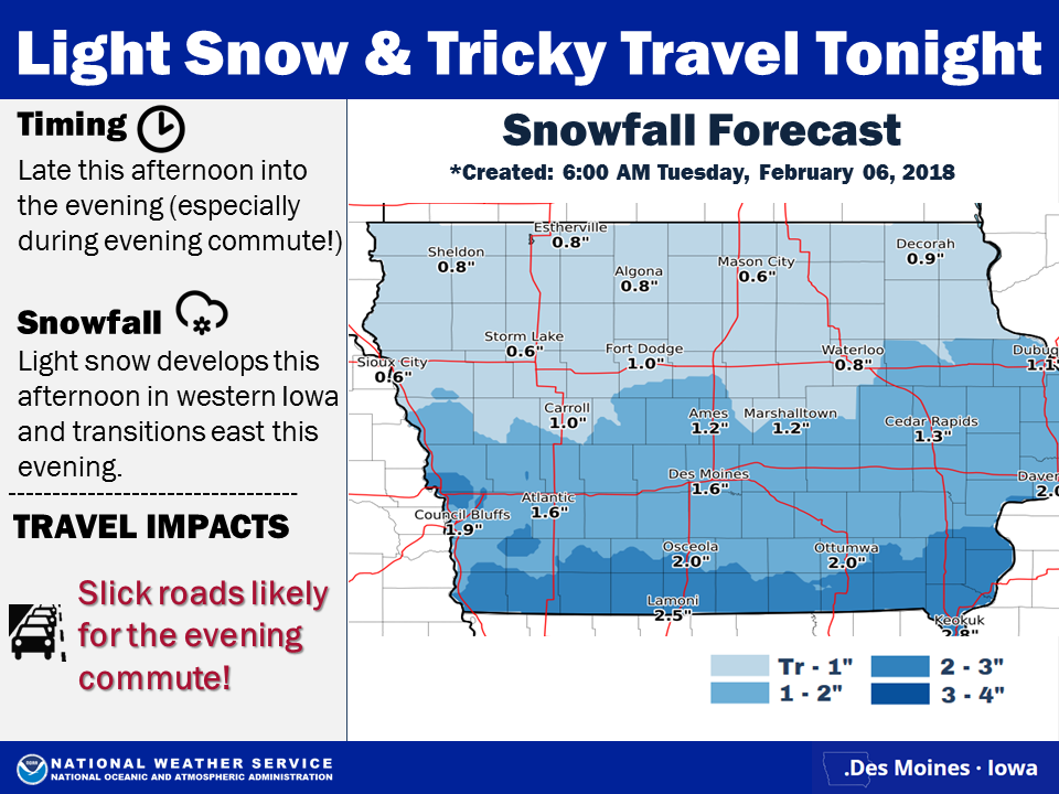 Motorists are asked to “Please, take it slow in the snow!!!” Additional light snow is forecast Thursday evening into Friday morning with even another round of snow possible on Saturday.
Today: P/Cloudy to Cldy w/snow developing this afternoon. High 13. SE @ 10.
Tonight: Light snow. (1-2” new accum. Possible) Low 8. V @ 5-10.
Tomorrow: P/Cloudy. High 20. W @ 5-10.
Thursday: Mo. Cloudy. High 28.
Friday: Mo. Cloudy w/light snow. High 23.
Monday’s High in Atlantic was 15. Our Low this morning was -13. We received 3 inches of snow Monday, which melted into .53″ liquid value. Last year on this date our High was 48 and the Low was 30. The record High in Atlantic on this date was 54 in 1966, and the Low was -27 in 1982.
Heavy snow is already falling in parts of northwest Iowa and soon, much of the state will be covered with a new blanket of white. Roger Vachalek (vah-HAUL-ick), a meteorologist at the National Weather Service, says this latest winter storm system is going to drop a lot of snow across most of Iowa today. “It will be spreading moderate-to-heavy at times snowfall across the region throughout the daytime hours and into the early evening,” Vachalek says. “This will be a quick-moving system but it is expected to drop anywhere from four to five inches of snow over a wide area.”
The heavy snow could cause challenges for anyone who has to be outside, especially motorists. “We don’t have a lot of wind with this snow but we are going to see about an inch per hour at times,” Vachalek says. “That means your visibility will be down to a half-mile, maybe less. If you’re traveling on area roads and interstates, be extremely cautious because the visibilities may impair your vision.” Both of Iowa’s major political parties are having their precinct caucuses tonight, putting more people on the roads than on a typical Monday night. The snow should be done falling in northwest Iowa by midday and in central Iowa by late afternoon, but eastern Iowa could have a difficult late-day commute due to the falling flakes. “For the early evening, there may be some impacts,” Vachalek says. “The big thing by that time is, the roads may be in rough shape in a few areas. The plows and state crews will be out working on area roads today and this evening but people should allow a little extra time to get to those caucuses tonight to be on the safe side.”
A wide area of east-central Iowa, including Cedar Rapids, Iowa City and the Quad Cities, may get six inches of snow today, or more. A Winter Weather Advisory is posted for most of Iowa. It covers all but 16 counties in southwest and south-central Iowa. “Following the snow tonight, it’s going to be rather cold,” Vachalek says. “We are expecting low temperatures across northern Iowa to be down to about ten-below and here in central Iowa, right around zero. Tomorrow morning, another shot of cold winter air following the system that’s going to be with us today.”
Keep up to date with the changing forecast on KJAN.
(Radio Iowa)
Today: Cloudy w/snow developing toward mid-day. High 19. E/SE @ 10-15.
Tonight: Snow diminishing early; Mostly cloudy. Low -8. N @ 10-15. (2-4” snow)
Tomorrow: Mo. Cloudy w/snow developing during the afternoon. High 15. SE @ 5-10.
Wednesday: P/Cloudy. High 18.
Thursday: Mo. Cloudy. High 28.
Sunday’s High in Atlantic was 15 Our Low this morning was -1. Last year on this date our High was 35 and the Low was 19. The record High in Atlantic on this date was 66 in 1948, and the Low was -26 in 1936.
A WINTER WEATHER ADVISORY for snow remains in effect from 6-a.m. today until 3-p.m. for the following counties: Monona-Harrison-Shelby-Sac-Crawford-Carroll-and Audubon, and a WINTER WEATHER ADVISORY for snow remain in effect from 6-a.m. until 7-p.m. today, for Guthrie-Dallas and Madison Counties. Snowfall ranging from 2-to 5-inches (from west to east across the advisory area) can be expected.
A Winter Weather Advisory for snow means periods of snow will cause primarily travel difficulties. Be prepared for snow covered roads and limited visibilities, and use caution while driving. The latest road conditions can be obtained by calling 5 1 1, or at 511ia.org on the web, in Iowa.


