
The National Weather Service says strong to severe thunderstorms are possible during the afternoon through evening hours today across mostly eastern and parts of southern Iowa, with damaging winds and a few tornadoes are the main threats. Most of these storms should weaken by 11 pm. However, the heavy rain threat will persist through today and tonight before the rain eventually ends on Wednesday morning.
Excessive rainfall is expected in a large swath of the state from Mason City and Decorah southwestward, to the southeast quarter of Fremont County. Cities included in the path of heavy rain include Waterloo, Ames, Marshalltown, Des Moines, Osceola and Lamoni. 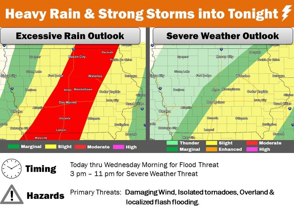
The southeastern half of Cass and Guthrie Counties and all of Adair, Adams, Madison, Union, Taylor and Ringgold Counties, can also expect heavy rain today, causing ponding of water on roads and localized flash flooding along with extensive overland flooding.
A FLOOD WATCH continues for the entire KJAN listening area until 7-a.m. Wednesday…
Periods of moderate to heavy rainfall are forecast through tonight, and perhaps into Wednesday morning. Early this morning widespread moderate to locally heavy rain is moving slowly northward into western Iowa, then this afternoon and evening additional thunderstorms will develop across much of the area. These late day storms may come with a higher risk of localized flash flooding, in addition to the more widespread threat of areal and river flooding. Additional rains of one to three inches are forecast, with locally higher amounts.
* Saturated soils in addition to expected heavy rainfall will lead to significant runoff into area streams and may result in extensive overland flooding and ponding water. Localized flash flooding may also occur. In addition, widespread river flooding may occur across the northern half of Iowa. PRECAUTIONARY/PREPAREDNESS ACTIONS… A Flood Watch means there is a potential for flooding based on current forecasts. You should monitor later forecasts and be alert for possible Flood Warnings. Those living in areas prone to flooding should be prepared to take action should flooding develop.
**A Flood Watch continues until 7-a.m. Wednesday**
Today: Cloudy w/showers & occasional thunderstorms producing heavy rain at times. High 65. Winds variable at 5-10 mph.
Tonight: Cloudy w/shwrs & tstrms, with areas of heavy rain. Low 48. NW @ 10-15.
Tomorrow: Rain ending in the morning. Mostly cldy. High 52. NW @ 15-25.
Thursday: Partly cloudy. High 52,
Friday: Mo. Cldy w/light rain possible. High 58.
Yesterday’s High in Atlantic was 71. Rainfall in Atlantic from 7-a.m. Monday thru 7-a.m. today was 1.32”. Our Low was 56. Last year on this date our High was 65 and the Low was 39. The record High in Atlantic on this date was 87 in 1930 & 1938. The Record Low was 14 in 2000.
The Cass County Emergency Management Agency reports periodic moderate to heavy rainfall is expected across the area today and persisting into early Wednesday. Conditions will become more and more prone to flooding with time as excessive amounts of rain continue to accumulate. The flood stage where action may be needed is 15-feet, with minor flooding occurring at 19-feet. As of 10-a.m. today (Monday), the East Nish was slightly under 5-feet. The river is expected to crest from 10-a.m. Tuesday to 10-a.m. Wednesday at around 17.4-feet before falling to below the action stage. The record crest for the river was 22.81-feet, in Sept., 1972. The river also crested above 22-feet in July, 1958 and June, 1998.
| Flood notes: | |
| 22.8-feet | Lansing Road floods on both sides of the river. |
| 21-feet | Flooding occurs in Atlantic. Widespread agricultural flooding occurs. |
| 20.5-feet | Water affects US 6. |
| 19-feet | Water affects agricultural land. |
| 17-feet | Water affects low lying areas west of Atlantic. |
**Flood Watch 7-a.m. Today thru 7-a.m. Wed.**
Today: Showers & occasional thunderstorms. High 65. SE @ 10-20.
Tonight: Showers w/periods of heavy rain. Low 60.
Tomorrow: Showers w/areas of heavy rain. High 72. S @ 10-20.
Wednesday: Cloudy to partly cloudy w/showers ending. High 52.
Thursday: P/Cldy. High 52.
Yesterday’s High in Atlantic was 57. From 7-a.m. Sunday through 7-a.m. Today, we received .77” rain. Our 24-hour Low was 45. Last year on this date our High was 82 and the Low was 51. The record High in Atlantic on this date was 93 in 1893. The Record Low was 19 in 1908 & 2000
The National Weather Service has expanded a FLOOD WATCH which is in effect from 7-a.m. today (Monday) through 7-a.m. Wednesday, for the entire KJAN listening area.
* Periods with heavy rainfall are forecast through the period. Expect an area with heavy rain beginning this morning with additional bouts tonight and again Tuesday and Tuesday night. Total accumulations after multiple days of rain may reach as high as three to six inches.
* Saturated soils in addition to expected heavy rainfall will lead to significant runoff into area streams and may result in extensive overland flooding and ponding water. Localized flash flooding may also occur. In addition, widespread river flooding may occur across the northern half of Iowa.
PRECAUTIONARY/PREPAREDNESS ACTIONS…
A Flood Watch means there is a potential for flooding based on current forecasts. You should monitor later forecasts and be alert for possible Flood Warnings. Those living in areas prone to flooding should be prepared to take action should flooding develop.
The National Weather Service, in its Flood Outlook for the next few days, reports moderate to heavy rain starts later tonight and continues on and off through Wednesday morning. This rain will lead to rises on area creeks/streams/rivers and may cause localized flash flooding. Widespread river flooding is possible over northern and parts of central Iowa. For More information -> https://www.weather.gov/dmx/sitrep.
The National Weather Service has issued a FLASH FLOOD WATCH in effect from 7-a.m. Monday through 7-a.m. Wednesday for the following area counties: Cass-Adair-Audubon-Guthrie-Dallas, Pottawattamie, Mills, Harrison, Shelby, Sac, Crawford, and Carroll.
A frontal system south of Iowa this evening will lift into the state overnight and then stall southwest to northeast Monday and Tuesday before finally exiting Wednesday morning. Unusually high amounts of moisture for fall will be in place near the system allowing for repetitive moderate to heavy rains. Total accumulations after multiple days of rain may reach as high as four to six inches across west central and northwest Iowa with two to four inch totals possible central and southeast.
* Soils are already at or near saturation so much of the rainfall will runoff into streams, creeks and rivers and may result in extensive overland flooding and standing water, ponding water on roads and even localized flash flooding. This is in addition to the potential of widespread river flooding across the northern half of Iowa.
PRECAUTIONARY/PREPAREDNESS ACTIONS… A Flood Watch means there is a potential for flooding based on current forecasts. You should monitor later forecasts and be alert for possible Flood Warnings. Those living in areas prone to flooding should be prepared to take action should flooding develop.


