
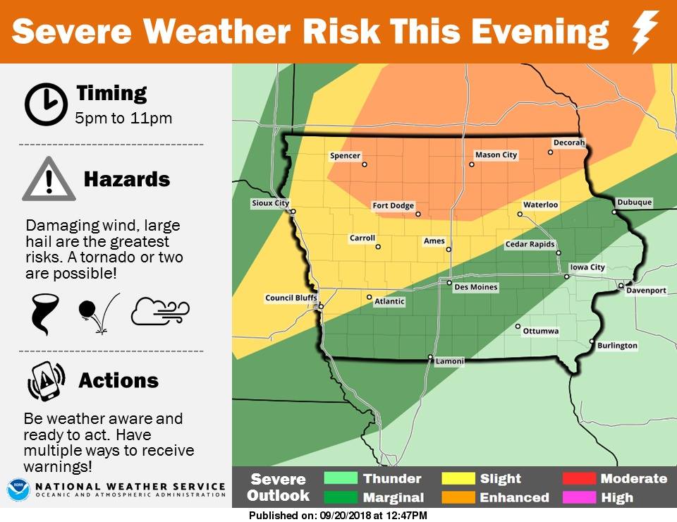
A line of showers and thunderstorms is expected to move from northwest to southeast across the area late this afternoon into tonight. Storms are expected to develop around 4-5pm across far northwest Iowa. Storms will move rapidly to the southeast with the peak impacts between 6pm and 11pm. Damaging winds, large hail and frequent lightning are the primary concerns. A tornado or two is also possible, although the higher tornado risk has shifted north into Minnesota. While a brief period of heavy rainfall is possible as the storms move through, the faster movement of storms should limit the flash flood threat. The greatest threat for severe weather is over the northern third of Iowa, with areas from Atlantic to Council Bluffs northward, to Carroll and east to Ames under a slight risk.
Today: Partly cloudy, warm & humid w/scattered late day showers & thunderstorms. High around 90. S @ 10-20 w/gusts to near 40.
Tonight: Mostly cloudy w/shwrs & tstrms. Low 56. NW @ 10-15.
Friday: P/Cldy & windy. High 68. NW @ 15-25.
Friday Night: Mostly clear, with a low around 43.
Saturday: Sunny, with a high near 73. E
Saturday Night: Clear, with a low around 50.
Sunday: P/Cldy. High near 80.
Yesterday’s High in Atlantic was 86. Our Low 67. Last year on this date our High was 83 and the Low was 59. The record High in Atlantic on this date was 95 in 1891. The Record Low was 28 in 1901 & 1962.
(Radio Iowa) — This is the last week of summer and forecasters at the National Climate Center are raising the odds of an El Nino weather pattern impacting our region soon. Meteorologist Dennis Todey, director of the U-S-D-A’s Midwest Climate Hub in Ames, says we may see a shift within a few months. “We get into El Nino conditions maybe by late fall but probably by mid-winter,” Todey says. “The probability is around 65 to 70% chance right now.”
Forecasting models indicate a weak El Nino is most likely, Todey says, but that’s just at the moment. “This one will probably not be a particularly strong one,” he says, “so, therefore, what we expect out of this, we can’t assume as much out of it this time. Typically, we talk about El Nino winters as higher likelihood of being warmer than average throughout most of the Northern Plains, the northern Midwest. That’s still the thinking.”
Todey says it’s a safer bet the impacts of the weather pattern will be felt more next year than this fall. “The other thing, when we have El Ninos, we expect a better chance of precipitation as you get into springtime,” Todey says. “The indications for fall aren’t as strong and we’re really not being impacted by El Nino right now, so, we can’t say too much about the fall as being too much different from average right now.”
Forecasts for the last three months of the year show near-normal temperatures and precipitation are likely for the region.
Area Counties: Sac-Crawford-Carroll-Audubon-Guthrie-Dallas-Cass-Adair-Madison-Adams-Union-Taylor and Ringgold….
Areas of dense fog have developed overnight and early this morning across portions of central, western, and southern Iowa. Scattered areas have seen visiblities drop to a mile or less, with others beginning to see restrictions as well. Travel this morning should be with caution, including usage of fog lights and reduced speeds.
Strong storms that moved into western Iowa Tuesday afternoon, brought hail, winds of up to 60 miles per hour, and caused scattered power outages. According to the National Weather Service, a thunderstorm wind gust of up to 60-mph at around 3-p.m. was recorded by an Iowa DOT system, and hail a bit larger than the size of peas was observed. The event occurred about two-miles south/southeast of Adair.
Four-miles north/northeast of Anita, about 10-minutes earlier, a DOT automated site recorded a 60-mile per hour gust of wind. Power lines and/or poles were reported down in Kimballton Tuesday afternoon, as well, after storms pushed their way through Shelby and Audubon Counties.
There were no other, immediate reports of damage or injuries.
Today: Partly cloudy w/isolated showers & thunderstorms this morning. High 88. S @ 10-20mph.
Tonight: P/Cldy w/isolated shwrs & tstrms. Low 70. S @ 10.
Tomorrow: P/Cldy, warm & humid w/scattered shwrs & tstrms. High 90. S @ 10-25.
Friday: Partly sunny & cooler. High 70.
Saturday: Mostly sunny. High 76.
Yesterday’s High in Atlantic was 85. Our Low 62. We received .31” rain here at the KJAN studios yesterday and overnight into this morning. Last year on this date our High was 85 and the Low was 63. The record High in Atlantic on this date was 95 in 1948. The Record Low was 33 in 1896 & 1938.
Today: Variably cloudy w/scattered showers & thunderstorms possible, mainly this afternoon. High around 87. SE @ 15-25mph.
Tonight: Mostly cloudy w/scatt. Shwrs & tstrms. Low 68. SE @ 5-10.
Tomorrow: Partly cloudy w/scattered showers & thunderstorms. High 89. S @ 10-20.
Thursday: P/Cldy w/afternoon shwrs & tstrms possible. High 89.
Friday: Any showers ending early; Becoming P/Cldy. High 72.
Yesterday’s High in Atlantic was 92. Our Low 65. Last year on this date our High was 74and the Low was 62. The record High in Atlantic on this date was 99 in 1893. The Record Low was 26 in 1901.
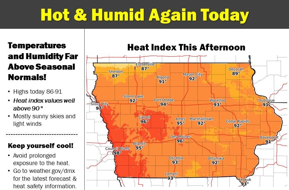
The National Weather Service says unseasonably hot weather continues today, with temperatures and humidity far above normal and near the levels of two days ago. With the heat index approaching mid-90s this afternoon along with mostly sunny skies and light winds, the heat may be hazardous to those engaging in strenuous outdoor activities. Please be sure to drink plenty of water and take breaks in the shade or indoors.
Today: Partly cloudy, warm & humid. High near 90. S @ 15-25mph.
Tonight: P/Cldy. Low 70. S @ 10.
Tomorrow: Variably cloudy w/scattered showers & thunderstorms. High 86. SE @ 10-15.
Wednesday: P/Cldy w/isolated shwrs & tstrms. High 88.
Thursday: V/Cldy w/scatt. Shwrs & tstrms. High 86.
Yesterday’s High in Atlantic was 89. Our Low 61. Last year on this date our High was 75 and the Low was 51. The record High in Atlantic on this date was 97 in 1925. The Record Low was 31 in 1980.


