
Today: Areas of fog this morning, otherwise partly cloudy. High 82. E/SE @ 5-10mph.
Tonight: P/Cldy. Low 55.
Tomorrow: P/Cldy. High 84. SE @ 10.
Friday: P/Cldy to Cloudy w/a chance late late day showers. High 82.
Saturday: Mostly cloudy w/scattered showers & tstrms. High 72.
Yesterday’s High in Atlantic was 79. Our Low was 53. Last year on this date our High was 88 and the Low was 61. The record High in Atlantic on this date was 93 in 1939. The Record Low was 25, in 1907.
Today: Areas of fog & low clouds this morning; P/Cldy otherwise. High 78. N @ 10.
Tonight: P/Cldy. Low 52.
Tomorrow: P/CLdy. High around 80. SE @ 5-10.
Thursday: P/Cldy. High 82.
Friday: Mo. Cldy w/scattered showers & tstrms. High around 80.
Yesterday’s High in Atlantic was 82. Our Low was 56. Last year on this date our High was 91 and the Low was 67. The record High in Atlantic on this date was 97 in 2017 and 1894. The Record Low was 29, in 1937, 1973 & 1983.
The National Weather Service says strong to potentially severe storms are forecast this afternoon and tonight over central to southern Iowa. The main threats will be large hail and damaging wind. In addition to the severe storms potential, heavy rain is likely to accompany these storms this afternoon and tonight. Generally, a half to an inch of rain is expected with a few isolated higher amounts will be possible by late tonight. Lingering storms are anticipated Tuesday morning. Otherwise, a much welcomed dry period is expected Tuesday night through the end of the work week. There is a low chance for storms Thursday afternoon in western Iowa. The storms are expected to fire-up at around 2-p.m. and last through about midnight. 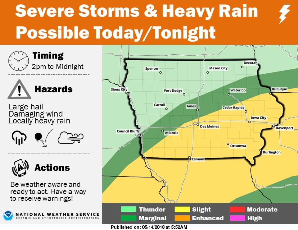
A marginal risk of severe storms is possible in an area that stretches from about Sidney to Council Bluffs, Atlantic northeast to Ames and Waterloo. A Slight risk exists south and east of that line, with mainly thunder over the remainder of western, northwest, north central and northeast Iowa.
Today: Partly-to-Mostly cloudy w/scattered showers & thunderstorms this morning and again late this afternoon. High 73. Variable winds @ 5-10mph.
Tonight: Mo. Cldy w/scatt. shwrs & tstrms. Low 58. Light & var. breeze.
Tomorrow: Showers ending early; P/Cldy. High 73. N @ 10.
Wednesday: P/Cldy. High 78.
Thursday: P/cldy. High near 80.
Yesterday’s High in Atlantic was 76. Our Low was 54. We received a total of .08” rain yesterday and early this morning. Last year on this date our High was 86 and the Low was 61. The record High in Atlantic on this date was 97 in 2013. The Record Low was 29, in 1937.
Today: Isolated showers and thunderstorms before 11am, then isolated showers and thunderstorms after 5pm. Areas of dense fog before 9am. Otherwise, cloudy, with a high near 74. NE wind 5-10mph becoming southeast this afternoon. Chance of precipitation is 20%.
Tonight: Showers and thunderstorms likely, mainly after 5am. Mostly cloudy, with a low around 61. E/NE wind around 5 mph. Chance of precipitation is 60%. New rainfall amounts between a tenth and quarter of an inch, except higher amounts possible in thunderstorms.
Monday: A 50 percent chance of showers and thunderstorms. Mostly cloudy, with a high near 77. NE wind 5-10mph becoming southeast in the afternoon. New rainfall amounts of less than a tenth of an inch, except higher amounts possible in thunderstorms.
Monday Night: Showers and thunderstorms likely, mainly before 1am. Mostly cloudy, with a low around 60. Chance of precipitation is 70%. New rainfall amounts between a quarter and half of an inch possible.
Tuesday: A 20 percent chance of showers and thunderstorms. Mostly cloudy, with a high near 78. North northeast wind 5-10mph.
Wednesday: Mostly sunny, with a high near 79.
Yesterday’s High in Atlantic was 59. We received .05″ rain Saturday into early this morning. Our Low was 49. Last year on this date, the High in Atlantic was 80 and the Low was 47. The All-time Record High on this date in Atlantic, was 95 in 1915, and the Record Low was 23 in 1997.
Cass-Adair-Madison–Adams-Union-Taylor- Ringgold Counties… 349 AM CDT Sun May 13 2018
Areas of dense fog will continue to plague portions of southern Iowa this morning with one half mile visibility or less at times. The is likely to persist through just after sunrise this morning before dissipating. Areas along Interstate 35 near Winterset south to the Missouri border as well as the Highway 2 and Highway 34 corridors west of Interstate 35 can expect significant visibility restrictions. If traveling early this morning, please use low beam headlights and allow extra space between you and the vehicle ahead of you.
Skyscan Forecast Saturday, May 12, 2018 Richard Garuckas
Today: Mostly cloudy. Scattered showers and thunderstorms. High 62. ENE @10-15, gusting to 20.
Tonight: Mostly cloudy. Moderate chance of showers and thunderstorms. Low 53. NE @ 5-10.
Sunday: Mostly cloudy. Slight chance of showers and thunderstorms. High 75. ENE @ 5-10.
Sunday Night: Mostly cloudy. Slight chance of showers and thunderstorms. Low 58.
Monday: Partly sunny. Moderate chance of showers and thunderstorms. High 81.
Tuesday: Partly cloudy. Slight chance of showers and thunderstorms. High 81.
Wednesday: Partly sunny. Slight chance of showers and thunderstorms. High 80.

Podcast: Play in new window | Download (752.9KB)
Subscribe: RSS
Mills IA-Montgomery IA-
620 AM CDT FRI MAY 11 2018
…Significant Weather Advisory for MONTGOMERY AND EASTERN MILLS
COUNTIES UNTIL 700 AM CDT…
At 620 AM CDT, Doppler radar was tracking a strong thunderstorm over
Emerson, or 33 miles southwest of Atlantic, moving east at 50 mph.
Dime size hail and winds in excess of 40 mph will be possible with
this storm.
Locations impacted include…
Red Oak, Villisca, Stanton, Emerson, Elliott, Henderson, Hastings,
Grant, Coburg and Viking Lake State Park.
This includes the following highways…
Highway 34 in Iowa between mile markers 23 and 51.
Highway 59 in Iowa between mile markers 25 and 37.


