
The (podcast) Freese-Notis weather forecast for the KJAN listening area, Flood Watch information, & weather info. for Atlantic.

Podcast: Play in new window | Download (1.4MB)
Subscribe: RSS
438 AM CDT TUE JUN 3 2014 T
TODAY AND TONIGHT: A FLASH FLOOD WATCH IS IN EFFECT FOR THE AREA. A MODERATE RISK OF SEVERE THUNDERSTORMS IS FORECAST LATE THIS AFTERNOON INTO THE EVENING. DAMAGING WINDS IN EXCESS OF 70 MPH…LARGE HAIL UP TO THE SIZE OF BASEBALLS…AND NIGHT TIME TORNADOES ARE ALL POSSIBLE BY THIS EVENING AND INTO THE OVERNIGHT HOURS.
WEDNESDAY: THUNDERSTORMS WITH LOCALLY HEAVY RAIN ARE FORECAST TO PERSIST INTO WEDNESDAY AFTERNOON…MAINLY EAST OF INTERSTATE 35.
SPOTTER ACTIVATION IS ANTICIPATED TONIGHT INTO WEDNESDAY MORNING…AND POSSIBLE OVER THE WEEKEND.
417 AM CDT TUE JUN 3 2014
EXTREMELY HEAVY RAIN TONIGHT…IN ADDITION TO THE SEVERE WEATHER THREAT,VERY HEAVY RAIN WILL ACCOMPANY THESE STORMS TONIGHT INTO THE EARLY MORNING HOURS WEDNESDAY. RAINFALL TOTALS WILL RANGE FROM 2 TO 4 INCHES WITH A FEW ISOLATED 5 INCH OR GREATER AMOUNTS POSSIBLE. THE HIGHEST RAINFALL RATES ARE ANTICIPATED TO BE 3 TO 5 INCHES PER HOUR AND MAY LEAD TO AREAS OF FLASH FLOODING.
AREA COUNTIES: AUDUBON-GUTHRIE-DALLAS-CASS-ADAIR-MADISON-ADAMS-UNION-TAYLOR-RINGGOLD …FLASH FLOOD WATCH IN EFFECT FROM 8-PM THIS EVENING THROUGH WEDNESDAY MORNING.
EXCESSIVE RAINFALL RATES OF 3 TO 5 INCHES PER HOUR ARE ANTICIPATED LATE THIS EVENING AND INTO THE OVERNIGHT HOURS. WIDESPREAD TOTAL PRECIPITATION AMOUNTS LOOK TO RANGE FROM 2 TO 4 INCHES BY WEDNESDAY MORNING…BUT COULD SEE ISOLATED AMOUNTS OF 5 INCHES OR GREATER.
* SMALL CREEKS AND STREAMS TYPICALLY SUSCEPTIBLE TO FLASH FLOODING MAY RISE VERY RAPIDLY TONIGHT…ESPECIALLY IN URBAN AREAS.
PRECAUTIONARY/PREPAREDNESS ACTIONS… A FLASH FLOOD WATCH MEANS THAT CONDITIONS MAY DEVELOP THAT LEAD TO FLASH FLOODING. FLASH FLOODING IS A VERY DANGEROUS SITUATION. YOU SHOULD MONITOR LATER FORECASTS AND BE PREPARED TO TAKE ACTION SHOULD FLASH FLOOD WARNINGS BE ISSUED.
Today: Scattered showers and thunderstorms, mainly after 5pm. Mostly sunny, with a high near 87. Light and variable wind becoming southeast 8 to 13 mph in the morning. Chance of precipitation is 30%. New rainfall amounts of less than a tenth of an inch, except higher amounts possible in thunderstorms.
Tonight:FLASH FLOOD WATCH FOR PARTS OF WESTERN/SW IOWA. Showers and thunderstorms. Some storms could be severe, with large hail, damaging winds, and heavy rain. Low around 65. Breezy, with an east southeast wind 8 to 18 mph, with gusts as high as 25 mph. Chance of precipitation is 90%. New rainfall amounts between 2 and 3 inches possible.
Wednesday: Showers and thunderstorms likely, mainly before 10am. Mostly cloudy, with a high near 75. Breezy, with an east wind 7 to 17 mph becoming north northwest in the morning. Winds could gust as high as 25 mph. Chance of precipitation is 60%. New rainfall amounts of less than a tenth of an inch, except higher amounts possible in thunderstorms.
Wed. Night: Partly cloudy, with a low around 57. Northeast wind 5 to 9 mph.
Thursday: Mostly sunny, with a high near 78. East southeast wind 6 to 8 mph.
Friday: A 20 percent chance of showers and thunderstorms. Mostly sunny, with a high near 78.
351 AM CDT TUE JUN 3 2014
HEAVY RAIN IS EXPECTED LATE THIS AFTERNOON THROUGH THE EVENING. STORMS WILL BRING HEAVY RAIN TO THE REGION BY THIS EVENING DROPPING ANYWHERE FROM 1 TO 3 INCHES OF RAINFALL. THIS COULD LEAD TO AREAS OF FLASH FLOODING.
HARRISON-SHELBY-POTTAWATTAMIE-MILLS-MONTGOMERY-FREMONT-PAGE COUNTIES…FLASH FLOOD WATCH IN EFFECT FROM 7-P.M. TUESDAY THROUGH WEDNESDAY MORNING.
* HEAVY RAIN IS EXPECTED TO DEVELOP BY LATE AFTERNOON OR EARLY EVENING AND CONTINUE INTO THE NIGHT. RAINFALL AMOUNTS OF 1-3 INCHES ARE POSSIBLE.
PRECAUTIONARY/PREPAREDNESS ACTIONS…
A FLASH FLOOD WATCH MEANS THAT CONDITIONS MAY DEVELOP THAT LEAD TO FLASH FLOODING. FLASH FLOODING IS A VERY DANGEROUS SITUATION. YOU SHOULD MONITOR LATER FORECASTS AND BE PREPARED TO TAKE ACTION SHOULD FLASH FLOOD WARNINGS BE ISSUED.
Officials with the National Weather Service say they are forecasting severe weather and flash flooding to become major threats to much of Iowa this upcoming Tuesday evening into Wednesday morning.
The latest forecast from the Storm Prediction Center shows the main threat for severe weather across the U.S. Tuesday will be across Iowa — mainly from Interstate 80 south. Heavy rainfall is expected with these storms. At this point, it shows a more than 45 percent probability of severe weather with the main threats of large hail, tornadoes and widespread damaging winds.
A combination of a much higher than usual amount of available moisture plus very strong wind shear will lead to a strong potential for severe thunderstorms. The storms are likely to move into western Iowa by around midnight, Tuesday. Tornadoes may occur during the overnight hours, so make sure you have a way to receive warning information near your bed before going to sleep.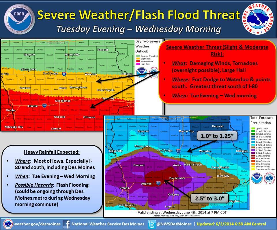
Several inches of rainfall are also possible by and during the Wednesday morning commute. This could lead to flash flooding in flood-prone areas. Additionally, the Des Moines metro is expected to be impacted by this rainfall, so plan for extra travel time during the Wednesday morning commute.
5-a.m. Mon., June 2nd 2014 – from Freese-Notis….
Today: Mostly sunny & breezy. High near 85. West winds @ 15-25mph.
Tonight: Mostly clear. Low around 56. Light & variable winds.
Tuesday: Sunny to Partly Sunny w/a 50% chance of showers and thunderstorms after 4pm. High 85. N winds becoming SE @ 5-15mph. New rainfall amounts of less than a tenth of an inch, except higher amounts possible in thunderstorms.
Tue. Night: Showers & thunderstorms, mainly after 7pm. Some storms could be severe, with large hail, damaging winds, and heavy rain. Low 65. SE @ 15-25. New rainfall amounts between 2 and 3 inches possible.
Wednesday: Mo. Cloudy w/a 40 percent chance of showers and thunderstorms, mainly before 1pm. High near 75. N @ 15-20. New rainfall amounts between a tenth
and quarter of an inch, except higher amounts possible in thunderstorms.
Thursday: Mo. Sunny w/a 20% chance of showers and thunderstorms. High near 75.
**********
Sunday’s High in Atlantic was 86. Our overnight low through 5-a.m. today: 63. Rainfall since Sunday evening (through 5-a.m. today) amounted to .8” (eight-tenths of an inch).
EARLY THIS MORNING…CLOUDY. SOUTH WIND 5 TO 10 MPH.
TODAY…MOSTLY SUNNY. HIGH IN THE MID 80S. WEST WIND 5 TO 15 MPH WITH GUSTS TO AROUND 25 MPH.
TONIGHT...MOSTLY CLEAR. LOW IN THE LOWER 60S. WEST WIND NEAR 10 MPH. GUSTS UP TO 20 MPH THROUGH MIDNIGHT.
TUESDAY…SUNNY IN THE MORNING…THEN PARTLY SUNNY WITH A SLIGHT CHANCE OF THUNDERSTORMS EARLY IN THE AFTERNOON. PARTLY SUNNY WITH A CHANCE OF THUNDERSTORMS LATE IN THE AFTERNOON. HIGH IN THE LOWER 80S. NORTHEAST WIND NEAR 5 MPH SHIFTING TO THE SOUTHEAST 5 TO 15 MPH IN THE AFTERNOON. CHANCE OF THUNDERSTORMS 50 PERCENT.
TUESDAY NIGHT…THUNDERSTORMS…BREEZY. SOME THUNDERSTORMS MAY BE SEVERE WITH DAMAGING WIND…LARGE HAIL AND HEAVY RAINFALL…THEN SOME THUNDERSTORMS MAY PRODUCE HEAVY RAINFALL AFTER MIDNIGHT. LOW IN THE MID 60S. SOUTHEAST WIND 10 TO 20 MPH WITH GUSTS TO AROUND 30 MPH. CHANCE OF THUNDERSTORMS NEAR 100 PERCENT.
WEDNESDAY…CLOUDY WITH A CHANCE OF THUNDERSTORMS IN THE MORNING…THEN PARTLY SUNNY WITH A SLIGHT CHANCE OF THUNDERSTORMS IN THE AFTERNOON. HIGH IN THE MID 70S. NORTH WIND 10 TO 15 MPH WITH GUSTS TO AROUND 25 MPH. CHANCE OF THUNDERSTORMS 50 PERCENT.
THURSDAY…PARTLY CLOUDY. A 20 PERCENT CHANCE OF THUNDERSTORMS. HIGH IN THE MID 70S.
Severe Thunderstorm Watch #201 which had been in effect until 10-p.m. Sunday for Mills, Monona, Harrison, Pottawattamie and Shelby Counties, has been cancelled.
625 PM CDT SUN JUN 1 2014

IAZ045-046-057-058-070-071-020000-
GUTHRIE IA-AUDUBON IA-CASS IA-CARROLL IA-ADAIR IA-GREENE IA-
625 PM CDT SUN JUN 1 2014

...LINE OF STRONG STORMS MOVING THROUGH WEST CENTRAL IOWA...

AT 624 PM CDT...DOPPLER RADAR WAS TRACKING A LINE OF STRONG
THUNDERSTORMS ALONG A LINE EXTENDING FROM 9 MILES NORTHEAST OF
GLIDDEN TO 8 MILES EAST OF GRISWOLD...AND MOVING EAST AT 40 MPH.

WIND GUSTS UP TO 50 MPH WILL BE POSSIBLE WITH THESE STORMS.

LOCATIONS IMPACTED INCLUDE...
JEFFERSON...GREENFIELD...GUTHRIE CENTER...STUART...COON RAPIDS...
GLIDDEN...PANORA...LAKE PANORAMA...ANITA...EXIRA...GRAND JUNCTION...
ADAIR...FONTANELLE...SCRANTON...BAYARD...CASEY...ORIENT...CHURDAN...
MASSENA AND MENLO.

PLEASE SEEK SHELTER IN A STURDY STRUCTURE UNTIL THESE STORMS HAVE
PASSED.


