
Today: Cloudy with a slight chance of rain, mainly this morning. High near 50. South winds at 10-15. Chance of precipitation is 20%.
Tonight: Fair to Partly Cloudy. Low around 30. South southwest wind at around 5 mph.
Friday: Areas of fog possible in the morning; Otherwise sunny. High near 67. Light west northwest wind becoming southwest at 5-to 15 mph, with gusts to around 20.
Friday Night: Mostly clear, with a low around 38.
Saturday: Partly Cloudy. High near 57. Northeast wind 5 to 15 mph.
Sunday: Cloudy with a 20% chance of light rain and/or snow in the morning then a slight chance of rain. High near 48.
Wednesday’s High in Atlantic was 52. Our Low this morning, 32.
The Freese-Notis forecast for Atlantic & the KJAN listening area, and weather data for Atlantic.
Podcast: Play in new window | Download (866.6KB)
Subscribe: RSS
(Updated 5-a.m.)
Early this morning: Mostly cloudy, with a steady temperature around 30. Light east wind.
Today: Mostly cloudy, with a high near 52. E/SE @ 5-10.
Tonight: Mostly cloudy, with a low around 35. SE @ 5 to 10 mph.
Thursday: Cloudy w/a chance of lite rain. High near 50. SE @ 10-15.
Thursday Night: Cloudy to Partly Cloudy. Low around 32.
Friday: Clear to Partly Cloudy. High near 65. W @ 5-10.
Friday Night: Mostly clear, with a low around 37.
Saturday: P/Cloudy to Cloudy. High near 52.
Tuesday’s High in Atlantic was 48. Our Low overnight through 5-a.m. today was 28.
AREA COUNTIES: POTTAWATTAMIE-MILLS-MONTGOMERY-FREMONT-PAGE
1240 PM CDT TUE MAR 17 2015
…ELEVATED FIRE DANGER THIS AFTERNOON…
NORTH WINDS AVERAGING 15 TO 25 MPH ALONG WITH LOW HUMIDITY AND DRY GRASSES WILL KEEP OUR FIRE DANGER ELEVATED FOR MOST OF THE AFTERNOON. WINDS WILL BEGIN TO DIE DOWN AS WE HEAD THROUGH THE DAY…BUT OUTDOOR BURNING IS STILL NOT ADVISED.
Officials with the Shelby County Emergency Management Agency are asking businesses and fire departments with Fire Danger signs in their windows, to set the signs at HIGH this week. Emergency Manager Bob Seivert says burning of any kind is restricted unless approval is received from local Fire Chief. Controlled burns that are not reported will result in Fire Department being dispatched, and Fires extinguished if determined to be un-safe. Please call 712-755-2124 with questions. The goal is to prevent fires, through good communication, public cooperation, and planning.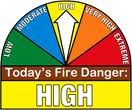
Seivert says also, when someone has the need to burn a pile of brush, debris, or buildings, they are asked to contact the Emergency Management Agency at 755-2124. The dispatchers will obtain the location and nature of the planned burn and will provide the caller with the Fire Chiefs contact information. Through this expanded communication process, we have found some burns can be rescheduled to a different time of day, where wind and moistures are more acceptable. The Fire Chiefs can have input as to how the burn can be conducted safely and be aware of the activity should it become unmanageable.
The Freese-Notis forecast & weather data, for Atlantic.
Podcast: Play in new window | Download (1,013.0KB)
Subscribe: RSS
415 AM CDT TUE MAR 17 2015
EARLY THIS MORNING…PARTLY CLOUDY. BREEZY. NORTH WIND 15 TO 25 MPH.
TODAY…SUNNY…BREEZY. MUCH COOLER. HIGH IN THE UPPER 40S. NORTHEAST WIND 10 TO 20 MPH WITH GUSTS TO AROUND 30 MPH.
TONIGHT…PARTLY CLOUDY. LOW IN THE UPPER 20S. EAST WIND NEAR 10 MPH.
WEDNESDAY…PARTLY SUNNY. HIGH IN THE LOWER 50S. SOUTHEAST WIND 5 TO 15 MPH. GUSTS UP TO 25 MPH IN THE AFTERNOON.
WEDNESDAY NIGHT…MOSTLY CLOUDY. LOW IN THE LOWER 30S. EAST WIND 5 TO 10 MPH.
THURSDAY…PARTLY SUNNY. HIGH IN THE LOWER 50S. SOUTHEAST WIND 5 TO 10 MPH.
THURSDAY NIGHT…MOSTLY CLOUDY. LOW IN THE MID 30S.
FRIDAY...MOSTLY SUNNY. WARMER. HIGH IN THE LOWER 60S.
This is the last Monday of winter but it’ll feel more like summer across much of Iowa with high temperatures approaching record territory. Meteorologist Brad Fillbach, at the National Weather Service, says most of the state will have highs in the 70s and 80s. “We are going to be warm today, much warmer than normal,” Fillbach says. “Our record for Des Moines today is 84 and we’re looking for highs in the lower 80s, so close, but probably not a record day.”
He says the warming trend will be boosting temperatures 20 to 30 degrees warmer than average for this date in many Iowa cities. “Normal highs for this time of the year, for the Des Moines area, are upper 40s and for the lows, you’re looking at the upper 20s, so well above normal but not quite the record levels.” A cool front is expected to drift over Iowa late tonight, bumping tomorrow’s (Tuesday) highs back down closer to normal. “We’re going to see a big change in temperatures tomorrow,” Fillbach says. “Where today, we’re lower 80s for highs and tomorrow we’re looking for lower 50s.”
Meteorologist Mindy Beerends, also at the National Weather Service, says a Red Flag Warning is posted for much of central, west-central and south-central Iowa today due to conditions raising the risk of wildfires. Beerends says, “We’re expecting gusty winds, low relative humidity and dry vegetation which is the combination factors for that Red Flag Warning and extreme fire conditions.”
Even with the big drop in high temperatures for tomorrow, Beerends says much of Iowa will still be slightly above-normal for highs for the rest of the week. Spring arrives on Friday.
(Radio Iowa)
Dry and windy conditions have prompted Emergency Management officials in Montgomery and Taylor Counties to issue a Burn Ban. The ban on opening burn in Montgomery County is in effect from Noon today (Monday), until further notice. The ban in Taylor County was ordered Friday and becomes effective today, as well.
A Red Flag warning is in effect for all of southwest and western Iowa this afternoon and this evening, for critical fire conditions (low humidity and high winds) that could create explosive fire growth.
The Freese-Notis weather forecast, and weather information for Atlantic.
Podcast: Play in new window | Download (1.5MB)
Subscribe: RSS


