
Pottawattamie IA-Mills IA-Montgomery IA-Shelby IA-Harrison IA-
532 PM CDT MON MAY 22 2017
…Significant Weather Advisory for NORTHWESTERN MONTGOMERY…
NORTHEASTERN MILLS…POTTAWATTAMIE…SOUTHEASTERN HARRISON AND SOUTHEASTERN SHELBY COUNTIES UNTIL 615 PM CDT…
At 531 PM CDT, Doppler radar was tracking strong thunderstorms along a line extending from 3 miles south of Irwin to 5 miles southwest of Underwood. Movement was southeast at 25 mph.
Hail up to around dime size and winds of around 40 mph will be possible with these storms.
Locations impacted include…
Northeastern Council Bluffs, Harlan, Oakland, Avoca, Treynor,
Underwood, Carson, Walnut, Shelby, Minden, Emerson, Irwin, Macedonia,
Neola, Hancock, Henderson, McClelland, Tennant, Kirkman and Old Town
Park.
Today: Partly cloudy to cloudy w/scattered showers & thunderstorms. High near 70. SW @ 10-20.
Tonight: Cldy w/shwrs. Low 48. NW @ 10-15.
Tomorrow: Mostly Cloudy w/scattered showers. High 57. N @ 10-20.
Wednesday: Partly cloudy to cloudy. High 63.
Thursday: P/Cldy. High 75.
Sunday’s High in Atlantic was 64. Our 24-hour Low ending at 7-a.m. today will be 43. Last year on this date, the High in Atlantic was 79 and the low was 49. The Record High in Atlantic on this date was 98 in 1925. The Record Low was 28 in 1895 & 1963.
Today: Gradually becoming mostly sunny. High near 61. West wind 15 to 30 mph.
Tonight: Mostly clear, with a low around 47. W/NW wind 10-20mph becoming light and variable.
Monday: Mostly sunny w/a 40% chance of showers & thunderstorms, especially during the afternoon. High near 74. W/SW @ 10-20 mph.
Monday Night: A 50% chance of showers & thunderstorms. Low around 48.
Tuesday: A 40 percent chance of showers, mainly after 1pm. Otherwise Partly sunny, with a high near 62. N/NW @ 15-25.
Wednesday: Mostly sunny, with a high near 65.
Sunday’s High in Atlantic was 65. Our Low this morning was 43. Rainfall in Atlantic over the past 24-hours ending at 7-a.m. Sunday, was .47″. Last year on this date, our High was 70 and the Low was 42. The All-time record High in Atlantic on this date was 97 in 1939. The record Low was 27 in 1895.
Skyscan Forecast Saturday, May 20, 2017 Richard Garuckas
Today: Mostly cloudy with morning showers likely then isolated showers in the afternoon. High 63. NNW @ 10-20 becoming W.
Tonight: Isolated showers tonight early then partly cloudy. Low 44. W @10-15.
Sunday: Mix of sun and clouds. High 68. WNW @ 10-20.
Sunday Night: Mostly clear. Low 43.
Monday: Mix of sun and clouds. High 72.
Tuesday: Partly cloudy. Isolated showers. High 65.
Wednesday: Partly sunny. Isolated showers. High 64.

Podcast: Play in new window | Download (738.1KB)
Subscribe: RSS
WASHINGTON, Iowa (AP) – The National Weather Service has confirmed that two tornadoes caused some eastern Iowa storm damage. The service says the first tornado touched down around 4:15 p.m. Wednesday in northeastern Jefferson County and lifted about four minutes later near Lake Darling in Washington County. It was rated EF-1 with winds reaching 110 mph that damaged farm outbuildings and trees.
The second struck around 6:35 p.m. in northeast Washington County and lifted six minutes later. It also was rated an EF-1 twister, damaging outbuildings, power lines and trees. No injuries have been reported.
Today: Cloudy w/scattered showeres & thunderstorms. High 57. E @ 10-20.
Tonight: Cldy w/shwrs & tstrms. Low 48. E @ 10-15.
Tomorrow: Mostly Cloudy w/showers & thunderstorms in the morning. High near 60. NW @ 10-20.
Sunday: Partly cloudy. High 68.
Monday: Cldy w/showers. High 63.
Thursday’s High in Atlantic was 63. Our Low this morning (as of 5:25-a.m.) was 50. We received .68” of rain overnight Thursday into early this morning at the KJAN studios. Last year on this date, the High in Atlantic was 69 and the low was 46. The Record High in Atlantic on this date was 94 in 1934 & 1975. The Record Low was 22 in 1894.
Today: Partly cloudy to cloudy. High 65. N @ 10-20.
Tonight: P/Cldy to Cldy w/rain developing late. Low 48. N @ 5-10.
Tomorrow: Cldy w/showers & thunderstorms. High near 60. E @ 10-20.
Saturday: Mo. Cldy w/shwrs in the morning. High 66.
Sunday: P/Cldy. High 68.
Wednesday’s High in Atlantic was 76. Our Low this morning (as of 5:20-a.m.) was 55. We received .05” of rain Wednesday (for a storm total of 1.83”) at the KJAN studios. Last year on this date, the High in Atlantic was 71 and the low was 42. The Record High in Atlantic on this date was 94 in 1934. The Record Low was 32 in 1891.
The Severe Storms Prediction Center in Norman, Oklahoma says another round of severe storms are possible across a large section of Iowa, this afternoon and this evening. The Primary threats include isolated, fast-moving, weak tornadoes, damaging winds, large hail, and periods of heavy rainfall.
Storms will develop this afternoon and will continue through the early evening. The greatest potential for severe weather will be during the peak heating evening commute hours from 3 pm – 7 pm. Storms should be out of our area around midnight.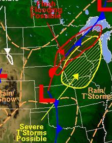
Most of Iowa is under an “Enhanced Risk” for severe weather. Locations south of I-80, and east of I-35 may see a slightly great threat for severe weather. Strong to severe storms that do develop will likely be very-fast moving, moving to the N/NE at potential speeds of 50 to 60 mph.


