
Active weather is on the way. The National Weather Service in Des Moines says scattered thunderstorms will return this afternoon and become more numerous later tonight over the southern counties. A few storms may produce large hail tonight over the south half of the area (including: Audubon-Guthrie-Dallas-Cass-Adair-Madison–Adams-Union-Taylor-Ringgold-Counties). Isolated severe storms are possible late this afternoon and tonight for the far west and southwest counties.
Saturday looks wet most of the day with a period of stronger thunderstorms in late afternoon and evening hours. A slight risk of severe thunderstorms is now forecast for the far south Saturday, with a marginal risk to near Interstate 80. Expect a wide range in temperatures from northwest to southeast today and Saturday. Strong northwest winds Saturday night will usher in much colder air by Sunday into Monday morning. Highs Sunday will only reach the 50s most areas. Lows Monday morning will fall to the 30s to lower 40s.
Today: Mostly cloudy w/a chance of light rain. High 62. NE @ 10-20 w/gusts to 25.
Tonight: Cloudy w/a 60% chance of rain. Low 54. NE @ 5-10.
Tomorrow: Cloudy showers & thunderstorms. High 69. E winds @ 5-10 becoming W this afternoon.
Tom. Night: Skies gradually clearining. Low 41.
Sunday: Becoming Mostly Sunny. High around 56.
Monday: Mostly sunny. High 65.
Tuesday: Mo. Sunny. High 69
Thursday’s High in Atlantic was 66. Our Low this morning: 48. Last year on this date, the High in Atlantic was 60 and the low was 27. The Record High in Atlantic on this date was 88 in 1975. The Record Low for this date was 15 in 1907.
Today: Areas of fog this morning; Otherwise Mostly Sunny. High 69. S-SE @ 10-20 w/gusts to 25.
Tonight: P/Cdy. Low 52. S/SE @ 5-10.
Tomorrow: Mo. Cloudy w/a 30% chance of rain. High 66. NE @ 5-15.
Tom. Night: Cldy w/a 60% chance of showers & thunderstorms. Low 54.
Saturday: Cloudy w/shwrs & tstrms. High around 67.
Sunday: Mostly sunny. High 56.
Monday: Mo. Sunny. High 64
Wednesday’s High in Atlantic was 66. Our Low this morning (as of 6-a.m.) was 41. Last year on this date, the High in Atlantic was 54 and the low was 28. The Record High in Atlantic on this date was 90 in 1899. The Record Low for this date was 17 in 1908.
The National Weather Service says FROST ADVISORIES will continue for parts of the KJAN listening area this morning. For Sac and Crawford Counties, a FROST ADVISORY is in effect until 8-a.m. For Monona and Harrison Counties, a FROST ADVISORY is in effect until 10-a.m. Temperatures in the Advisory area will be at or around freezing (32-degrees). Unprotected plants and/or vegetation could be damaged if left uncovered.
Today: Partly to Mostly Sunny. High 59. NE-SE @ 5-10.
Tonight: Fair to P/Cdy. Low 40. SE @ 5.
Tomorrow: Mo. Sunny. High near 70. S @ 10-20.
Friday: P/Cldy to Cldy. High around 70.
Saturday: Mo. Cloudy & cooler w/rain. High around 58.
Tuesday’s High in Atlantic was 46. Our Low this morning (as of 5-a.m.) was 40. We received .17” rain yesterday, for a storm total of .74”. Last year on this date, the High in Atlantic was 77 and the low was 46. The Record High in Atlantic on this date was 93 in 1893. The Record Low for this date was 17 in 1987.
Skyscan Forecast – Dan Hicks – Tuesday, 10/10/17
Today: Cloudy w/rain. High 48. N @ 10-20.
Tonight: Cloudy to P/Cdy. Low 37. N @ 5-10.
Tomorrow: Morning fog; P/Cldy. High 58. SE @ 5-10.
Thursday: P/Cldy. High around 70.
Friday: P/Cloudy to cloudy. High around 72.
Monday’s High in Atlantic was 65. Our Low this morning (as of 5:50-a.m.) was 39. 24-hour Rainfall as of 7-a.m. was .57″. Last year on this date, the High in Atlantic was 66 and the low was 56. The Record High in Atlantic on this date was 96 in 1893. The Record Low for this date was 17 in 1906.
For the first time this season, parts of Iowa are under a Freeze Warning and residents in the far northwestern counties will need to take precautions if they hope to save their flowers and garden vegetables. Meteorologist Mike Fuhs, at the National Weather Service bureau in Sioux Falls, says the Freeze Warning runs from midnight tonight (Monday) through 9 A-M on Tuesday. “In Lyon County, up in the far northwest corner, we are expecting temperatures to dip down to 32-degrees or less,” Fuhs says. “In the Frost Advisory counties, we are expecting a bit more mild temperatures with readings dropping down into the 33- to 34-degree range.”
Neighboring Osceola and Sioux counties are the ones under the Frost Advisory. Iowans in those areas who have still have blooming flowers, tomatoes on the vine or other tender vegetation, should cover those plants tonight with sheets, blanket or styrofoam cones. “This is the type of a freeze and frost that should -not- get down to the 20-to-25-degree range which would just kill everything,” Fuhs says. “Staying in the upper 20s and lower 30s, if you cover your vegetation up, it’s possible it will survive until the next freeze.”
While parts of central Iowa saw highs on Sunday in the 80s, Fuhs says that weather is gone for now, as a mostly-chilly week is ahead. “We’re looking at near-normal to just below-normal temperatures,” Fuhs says. “They will modify a little bit so we’re not expecting any more in the way of frost and freeze for the rest of the week but by the same token, it will have a difficult time warming up. Our warmest day of the week will probably be Thursday when temperatures get up into the upper 60s.”
Parts of central and southern Iowa may see highs in the low 70s on Thursday. Tonight’s first freeze for northwest Iowa is right on schedule, he says, as it usually arrives within the first ten days of October.
(Radio Iowa)
Today: Increasing cloudiness. High 64. N @ 10-20.
Tonight: Cloudy w/light rain. Low 42. N @ 10-20.
Tomorrow: Showers. High 50. N @ 10-20.
Wednesday: P/Cldy. High around 60.
Thursday: P/Cloudy. High around 70.
Sunday’s High in Atlantic was 82. Our Low this morning 51. Last year on this date, the High in Atlantic was 73 and the low was 39. The Record High in Atlantic on this date was 87 in 1930 & 1938. The Record Low for this date was 14 in 2000.
Skyscan Forecast Saturday, October 7, 2017 Richard Garuckas
Today: Cloudy and showers likely. WNW @ 10-15, gusting to 25. High 66.
Tonight: Clearing skies. S @ 5-10. Low 51.
Sunday: Mostly sunny. S @ 5-10. High 75.
Sunday Night: Mostly clear. Cooler. Low 48.
Monday: Partly sunny. Cool. High 64.
Tuesday: Mostly cloudy. Chance of Showers. High 55.
Wednesday: Mostly sunny. High 66.

Podcast: Play in new window | Download (695.5KB)
Subscribe: RSS
A FLASH FLOOD WATCH remains in effect until 7-a.m. Saturday for the following counties in Western Iowa: Sac-Crawford-Carroll-Greene-Audubon-Guthrie-Dallas-Cass-Adair-Madison-Adams-Union-Taylor-Ringgold.
A FLOOD WATCH remains in effect until 5-a.m. Saturday for these counties: Harrison-Shelby-Pottawattamie-Mills-Montgomery-Fremont-Page.
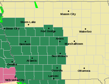 FLOOD WATCH details: Occasional rounds of showers and thunderstorms with heavy rain potential are expected through tonight. Additional amounts of 1 to 3 inches are possible, which would put storm total rains from Thursday through tonight in the 2 to 6 inch range. Flooding of low-lying area, urban areas and eventually rivers and streams could result.
* In addition to the general flood threat, faster or flash flooding, could occur with some storms that may develop through this evening in southeast Nebraska and southwest Iowa.
FLASH FLOOD WATCH details: Widespread rainfall amounts of 1 to 3 inches of rain can be expected through Saturday morning, with locally higher amounts in excess of 3 inches likely. Rainfall rates will be heavy at times with the potential for rainfall amounts of 2 inches occurring in an hour or less.
* Heavy rainfall may lead to rapid rises on local creeks and streams which may be high enough to cross roadways, especially low lying areas. Significant ponding of water on roadways is expected at times as well. Flash flooding at night is extremely dangerous and drivers should turn around if they come to an area where water is flowing over the road.
PRECAUTIONARY/PREPAREDNESS ACTIONS…
A Flash Flood Watch means that conditions may develop that lead to flash flooding. Flash flooding is a VERY DANGEROUS SITUATION. You should monitor later forecasts and be prepared to take action should Flash Flood Warnings be issued.


