
COUNTIES: MONONA-HARRISON-SHELBY-POTTAWATTAMIE-MILLS-MONTGOMERY-FREMONT-PAGE–
1120 AM CDT THU JUL 25 2013
THIS AFTERNOON AND TONIGHT….
THERE IS A CHANCE OF THUNDERSTORMS THIS AFTERNOON AND TONIGHT. A
FEW OF THESE STORMS COULD BE SEVERE WITH LARGE HAIL AND STRONG
WINDS. THE MAIN TIME FRAME THAT STORMS WOULD BE THE STRONGEST IS
FROM LATE THIS AFTERNOON THROUGH MID EVENING.
WARM…MOIST AND UNSTABLE AIR WILL CONTINUE TO MOVE INTO THE
REGION THIS AFTERNOON AND EARLY EVENING. IN ADDITION…A COLD
FRONT WILL BE PUSHING SOUTHEAST ACROSS THE LOCAL AREA. SCATTERED
STORMS ARE EXPECTED ALONG AHEAD OF THE FRONT. LOCALLY HEAVY RAIN
MAY ALSO OCCUR WITH THE STRONGER STORMS.
A cold front will move into far northern Iowa this evening and will become the focus for thunderstorm development into the evening. A few severe storms may occur with large hail and damaging winds possible. 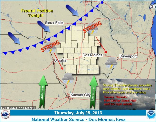 The cold front will move through the state overnight with showers and thunderstorms ending across southeast Iowa during the morning. Another push of cool and dry Canadian air will follow. Temperatures will be much cooler by Saturday with highs in the upper 60s to mid 70s expected.
The (podcast) Freese-Notis weather forecast for the KJAN listening area, and weather information for Atlantic….
Podcast: Play in new window | Download (1.2MB)
Subscribe: RSS
344 AM CDT THU JUL 25 2013
EARLY THIS MORNING…PARTLY CLOUDY. SOUTH WIND NEAR 5 MPH.
TODAY…PARTLY SUNNY. SCATTERED THUNDERSTORMS EARLY IN THE AFTERNOON. THUNDERSTORMS LIKELY LATE IN THE AFTERNOON. HIGH IN THE LOWER 80S. TEMPERATURE STEADY OR SLOWLY FALLING IN THE AFTERNOON. SOUTHWEST WIND 5 TO 15 MPH. CHANCE OF THUNDERSTORMS 60 PERCENT.
TONIGHT…THUNDERSTORMS LIKELY UNTIL EARLY MORNING…THEN A CHANCE OF THUNDERSTORMS EARLY IN THE MORNING. LOW IN THE LOWER 60S. SOUTH WIND NEAR 5 MPH SHIFTING TO THE WEST AFTER MIDNIGHT. CHANCE OF THUNDERSTORMS 70 PERCENT.
FRIDAY…PARTLY SUNNY. A 20 PERCENT CHANCE OF THUNDERSTORMS IN THE MORNING. HIGH IN THE UPPER 70S. NORTHWEST WIND 5 TO 15 MPH.
FRIDAY NIGHT AND SATURDAY…MOSTLY CLEAR. LOW IN THE LOWER 50S. HIGH IN THE MID 70S. NORTHWEST WIND NEAR 10 MPH.
SATURDAY NIGHT AND SUNDAY…PARTLY CLOUDY. LOW IN THE MID 50S. HIGH IN THE MID 70S.
SUNDAY NIGHT…MOSTLY CLOUDY WITH A 40 PERCENT CHANCE OF THUNDERSTORMS. LOW IN THE LOWER 60S.
The (podcast) Freese-Notis weather forecast for the KJAN listening area, and weather information for Atlantic….
Podcast: Play in new window | Download (869.4KB)
Subscribe: RSS
429 AM CDT WED JUL 24 2013
EARLY THIS MORNING…MOSTLY CLEAR. NORTHEAST WIND NEAR 5 MPH.
TODAY…PARTLY SUNNY. HIGH IN THE LOWER 80S. NORTH WIND NEAR 5 MPH.
TONIGHT…PARTLY CLOUDY. LOW IN THE LOWER 60S. SOUTH WIND NEAR 5 MPH.
THURSDAY…PARTLY SUNNY. HIGH IN THE MID 80S. SOUTH WIND 5 TO 10 MPH.
THURSDAY NIGHT…PARTLY CLOUDY THROUGH MIDNIGHT THEN BECOMING MOSTLY CLOUDY. A 50 PERCENT CHANCE OF THUNDERSTORMS. LOW IN THE LOWER 60S. SOUTH WIND NEAR 5 MPH.
FRIDAY…PARTLY SUNNY WITH A 40 PERCENT CHANCE OF THUNDERSTORMS. HIGH IN THE UPPER 70S. NORTH WIND NEAR 10 MPH.
FRIDAY NIGHT THROUGH SUNDAY…PARTLY CLOUDY. LOW IN THE MID 50S. HIGH IN THE UPPER 70S.
A climatologist with Iowa State University Extension says regional weather patterns have entered an erratic period, but farmers can reap high rewards if they play the markets right. Climatologist Elwynn Taylor says over the last 140 years, there has tended to be 18 years of “benign” weather followed by 25 years of “volatile” weather. “The kind of thing that gives much greater risk to the production of crops,” Taylor says. “Some years might be great, but other years might be a disaster. Of course 1936 — the worst production year in the Midwest in the past century — was in the middle of one of those 25-year periods.”
The major droughts of 1983 and ’88 and the massive flooding in 1993 were in the last “volatile” weather cycle, according to Taylor. “It was extreme weather and we also had some years with record-high crop yields,” Taylor says. “….We can get very good years (and) very bad years during what we call the ‘extreme years’ that go on for a 25-year period, historically.” Plant breeders have developed seed varieties that can endure heat, excessive moisture and drought — and Taylor says the pressure is now on farmers to analyze weather patterns and figure out when to sell their crop.
“People that work in the selling and buying of crops find that their greatest income is in periods of greatest volatility — where prices are going up and down, they can take advantage of this,” Taylor says. “Our farmers can do the same thing.” Taylor says buying crop insurance and selling their crops at the right time will help farmers yield greater profits during this 25-year cycle of “extreme” weather than during the previous18-year period of “benign” weather.
Taylor spoke today (Tuesday) at the Iowa Farm Bureau’s Economic Summit in Ames.
(Radio Iowa)
High winds, heavy rain and hail walloped parts of Iowa last night as a cold front pushed out the extreme heat. Meteorologist Rod Donovan, at the National Weather Service, says the biggest hail fell in north-central Iowa.The Clarion area reported two-inch diameter hail, as did Boone, with smaller hailstones the size of golf balls reported in Garner.
Some areas had tree damage with winds gusting to 65 miles an hour. In the KJAN listening area, quarter-sized hail was reported by spotters in Guthrie Center just after 9-p.m. Quarter-sized hail and winds of 40-50mph occurred near Bagley, in Guthrie County, at around 8:30-p.m. A few minutes earlier, nickel-to quarter-size hail fell in Avoca. Quarter-sized hail also fell at around 8:10-p.m., three-miles northeast of Shelby. Half-dollar-sized hail fell at around 7:20-p.m. four miles South of Missouri Valley in Pottawattamie Co., and quarter-to half-dollar sized hail fell at around 7:10-p.m., one-mile south of Missouri Valley, in Harrison Co.
Donovan says the storm front is leaving behind weather that’s much cooler that it was a year ago. The forecast is for highs in the 70s and 80s for the next several days with another cold front expected by the weekend, keeping highs only in the 70s. Last night’s severe storms forced the cancellation of a host of planned events in Perry for the thousands of overnight visitors on RAGBRAI, who head for Des Moines today.
(Radio Iowa/KJAN – Ric Hanson)
Rain fell in parts of Iowa this weekend providing some much needed moisture to Iowa corn and soybean fields, but the showers were isolated, for soil that has been drying back out. Iowa State Extension Agronomist Clark McGrath covers the counties from Carroll to the Missouri border. He says it’s dry, but conditions are better than last year. “Last year at this time, it was entire fields, and this year, luckily, it’s portions of fields. So, yeah, we could us moisture,” McGrath says. “But after talking to people from across the state — actually RAGBRAI just came through and I talked to farmers from southeast Iowa and east-central Iowa — and they said that they felt like southwest Iowa here was some of the best stuff they’d seen, and I kinda agree with that.”
Joel DeJong is another extension agronomist who covers nine-western-Iowa counties from Sibley to Missouri Valley. He says the rain is important as the corn crop hits a critical stage.
“We’re entering that time period when it’s the most critical time period. It’s at pollination where we really determine where how many kernels we end up with on those ears. The next five weeks after that, it’s kernel fill, but the next four weeks determines what our ultimate potential is,” Dejong explains. “And so, if we can’t get rainfall we would like to bring our average daily temperatures down into that highs into the lower to mid-80s rather than the lower to mid 90s because, that drops daily moisture demand almost in half.”
Dejong says the crops are showing moisture stress. “We haven’t had but a half inch of rain in the last three, four weeks, so we’re starting to see more and more on a daily basis, those plants curling, particularly in the corn fields — and in the lighter soils — the corn is basically turning white,” according to DeJong. He says the plants need an inch of rain daily at this stage of their growth.
(Radio Iowa)
The (podcast) Freese-Notis weather forecast for the KJAN listening area, and weather information for Atlantic….
Podcast: Play in new window | Download (1.1MB)
Subscribe: RSS


