
CHICAGO (AP) – Unseasonably cool temperatures will arrive next week in the Midwest and as far south as Arkansas and Oklahoma. It is not, however, the second coming of a polar vortex, something the National Weather Service says it regrets tweeting earlier this week.
Weather Underground meteorology director Jeff Masters says the weather pattern is similar to those dreaded words, but the key difference is that the chilly air mass isn’t coming directly from the arctic.
Masters says that Typhoon Neoguri in Japan altered the path of the jet stream and allowed polar air to spill out of Canada. That means next week’s temperatures will be as much as 15 degrees cooler than normal in the Midwest and could reach 90 in the normally temperate Pacific Northwest.
GUTHRIE IA-AUDUBON IA-CARROLL IA-GREENE IA-
659 AM CDT FRI JUL 11 2014
…STRONG THUNDERSTORMS CAPABLE OF SMALL HAIL AND HEAVY RAIN…
AT 659 AM CDT…DOPPLER RADAR WAS TRACKING A LINE OF STRONG
THUNDERSTORMS ALONG A LINE EXTENDING FROM 5 MILES NORTHWEST OF
AUDUBON TO 16 MILES NORTHEAST OF ATLANTIC…AND MOVING NORTHEAST AT
25 MPH.
NICKEL SIZE HAIL AND WINDS IN EXCESS OF 30 MPH WILL BE POSSIBLE WITH
THESE STORMS.
LOCATIONS IMPACTED INCLUDE…
AUDUBON…GUTHRIE CENTER…COON RAPIDS…LAKE PANORAMA…EXIRA…
SCRANTON…BAYARD…BAGLEY…DEDHAM…YALE…RALSTON…GRAY…LAKIN
SLOUGH GAME MANAGEMENT AREA…AUDUBON COUNTY AIRPORT AND SPRINGBROOK
STATE PARK.
GUTHRIE IA-CASS IA-MADISON IA-ADAIR IA-ADAMS IA-
648 AM CDT FRI JUL 11 2014
…STRONG THUNDERSTORM CAPABLE OF SMALL HAIL…
AT 648 AM CDT…DOPPLER RADAR WAS TRACKING A STRONG THUNDERSTORM 11
MILES NORTHEAST OF LAKE ICARIA…OR 11 MILES SOUTHWEST OF
GREENFIELD…MOVING NORTHEAST AT 25 MPH.
DIME SIZE HAIL AND WINDS IN EXCESS OF 30 MPH WILL BE POSSIBLE WITH
THIS STORM.
LOCATIONS IMPACTED INCLUDE…
GREENFIELD…STUART…FONTANELLE…DEXTER…ORIENT…MASSENA…
MENLO…BRIDGEWATER…GREENFIELD MUNICIPAL AIRPORT AND NODAWAY PARK.
Moisture returns to the region Friday and into the weekend with a series of disturbances combined with a stationary boundary expected to stall across central Iowa tonight (Friday) through Sunday. The National Weather Service says that combination will provide periods of thunderstorms late tonight through Sunday. The greatest chance for thunderstorms with heavy rain and severe weather will be Scattered thunderstorms central and north today will become numerous across the state tonight.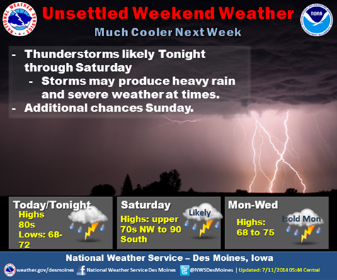
Thunderstorms are expected again Saturday in to Saturday evening. Some of the storms may be severe, producing heavy rain, high winds, and hail this afternoon in the west, and over the state Saturday afternoon and evening. Isolated thunderstorms are possible Sunday into Monday, followed by sharply cooler temperatures more typical of mid May on Tuesday.
COUNTIES: TAYLOR IA-UNION IA-ADAIR IA-RINGGOLD IA-ADAMS IA-
615 AM CDT FRI JUL 11 2014
…THUNDERSTORMS WITH HEAVY RAIN AND SMALL HAIL EXPECTED…
AT 614 AM CDT…DOPPLER RADAR WAS TRACKING A LINE OF STRONG THUNDERSTORMS ALONG A LINE EXTENDING FROM NEAR LAKE ICARIA TO 6 MILES SOUTHEAST OF BEDFORD…AND MOVING EAST AT 30 MPH. DIME SIZE HAIL WILL BE POSSIBLE WITH THESE STORMS.
LOCATIONS IMPACTED INCLUDE…
CRESTON…MOUNT AYR…CORNING…BEDFORD…LENOX…GREEN VALLEY
LAKE…LAKE ICARIA…CLEARFIELD…DIAGONAL…PRESCOTT…BLOCKTON…
GRAVITY…CROMWELL…SHARPSBURG…REDDING…SHANNON CITY…KENT…
BENTON…CONWAY AND CARBON.
PRECAUTIONARY/PREPAREDNESS ACTIONS…
TORRENTIAL RAINFALL IS ALSO OCCURRING WITH THESE STORMS…AND MAY
LEAD TO FLASH FLOODING. DO NOT DRIVE YOUR VEHICLE THROUGH FLOODED
ROADWAYS.
FREQUENT CLOUD TO GROUND LIGHTNING IS OCCURRING WITH THESE STORMS.
LIGHTNING CAN STRIKE 15 MILES AWAY FROM A THUNDERSTORM. SEEK A SAFE
SHELTER INSIDE A BUILDING OR VEHICLE.
Thursday’s High in Atlantic was 82, our 24-hour ending at 7-a.m. will be 64. (At 6-a.m. in Atlantic, it was 68. ) Here’s the Freese-Notis weather forecast:
Today – P/Cldy to Cldy w/a 30% chance of showers & thunderstorms (Mainly this morning). High 84. S @ 10-15.
Tonight – Mo. Cldy w/a 40% chance of showers and thunderstorms, mainly after midnight. Low around 69. S @ 5-10.
Saturday – P/Sunny w/a 50% chance of afternoon showers & thunderstorms. High near 87. S-SE winds becoming southwest @ 5-10.
Sat. Night – Mo.Cldy w/a 50% chance of showers & thunderstorms. Low 66.
Sunday – P/Sunny w/a slight chance of shwrs & tstrms. High near 85. N @ 5-10.
Monday – P/Sunny w/a 40% chance of showers and thunderstorms. High near 76.
401 AM CDT FRI JUL 11 2014
EARLY THIS MORNING…MOSTLY CLOUDY. SOUTH WIND 5 TO 10 MPH.
TODAY…PARTLY SUNNY. ISOLATED THUNDERSTORMS IN THE MORNING. HIGH IN THE MID 80S. SOUTH WIND 10 TO 15 MPH. CHANCE OF THUNDERSTORMS 20 PERCENT.
TONIGHT…MOSTLY CLOUDY WITH A SLIGHT CHANCE OF THUNDERSTORMS THROUGH MIDNIGHT…THEN PARTLY CLOUDY WITH A CHANCE OF THUNDERSTORMS AFTER MIDNIGHT. LOW IN THE LOWER 70S. SOUTH WIND 5 TO 10 MPH. CHANCE OF THUNDERSTORMS 50 PERCENT.
SATURDAY…PARTLY SUNNY. A CHANCE OF THUNDERSTORMS THROUGH MID MORNING. A CHANCE OF THUNDERSTORMS IN THE AFTERNOON. HIGH IN THE UPPER 80S. SOUTHWEST WIND 5 TO 15 MPH. CHANCE OF THUNDERSTORMS 50 PERCENT.
SATURDAY NIGHT...MOSTLY CLOUDY WITH A 50 PERCENT CHANCE OF THUNDERSTORMS. LOW IN THE UPPER 60S. NORTH WIND 5 TO 10 MPH.
SUNDAY…MOSTLY SUNNY WITH A 20 PERCENT CHANCE OF THUNDERSTORMS. HIGH IN THE MID 80S. NORTH WIND 5 TO 10 MPH.
SUNDAY NIGHT…MOSTLY CLOUDY WITH A 20 PERCENT CHANCE OF THUNDERSTORMS. LOW IN THE LOWER 60S.
MONDAY…PARTLY SUNNY WITH A CHANCE OF SHOWERS AND ISOLATED THUNDERSTORMS. HIGH IN THE MID 70S. CHANCE OF PRECIPITATION 40 PERCENT.
Wednesday’s High was 81. Our Low this morning (through 5-a.m.) was 61. (The 24-hour Low ending at 7-am will be 55)
Today – Patchy fog before 7am. Otherwise, mostly sunny, with a high near 83. Breezy, with a south southeast wind 6 to 11 mph increasing to 12 to 17 mph in the afternoon. Winds could gust as high as 25 mph.
Tonight – Showers and thunderstorms likely, mainly after 3am. Some of the storms could produce heavy rain. Mostly cloudy, with a low around 67. South southeast wind 10 to 14 mph, with gusts as high as 18 mph. Chance of precipitation is 60%. New rainfall amounts between a quarter and half of an inch possible.
Friday – Showers and thunderstorms likely, mainly before 1pm. Mostly cloudy, with a high near 85. South wind 9 to 13 mph. Chance of precipitation is 60%. New rainfall amounts between a tenth and quarter of an inch, except higher amounts possible in thunderstorms.
Friday Night – A 40 percent chance of showers and thunderstorms after 7pm. Mostly cloudy, with a low around 70. South southeast wind around 7 mph becoming east northeast after midnight. New rainfall amounts between a quarter and half of an inch possible.
Saturday – A 40 percent chance of showers and thunderstorms. Mostly cloudy, with a high near 84. New rainfall amounts between a quarter and half of an inch possible.
Saturday Night – A 50 percent chance of showers and thunderstorms. Mostly cloudy, with a low around 67.
Sunday – A 20 percent chance of showers and thunderstorms. Mostly sunny, with a high near 84.
Tuesday’s High in Atlantic was 79. Our low 57. There was no precipitation.
Today – Mostly Sunny. High near 81. NW @ 5.
Tonight – Partly cloudy, with a low around 61.
Thursday – Partly Sunny w/a 20% chance of showers & thunderstorms. High near 83. SE @ 10-20.
Thu. Night – Showers and thunderstorms likely. Low around 67. SE @ 10-20.Chance of precipitation is 70%. New rainfall amounts between a quarter and half of an inch possible.
Friday – P/Sunny w/a 40% chance of showers & thunderstorms, mainly before 1pm. High near 86. S-SE @ 10.
Fri. Night – Mostly Cloudy w/a 20% chance of showers and thunderstorms. Low around 70.
Saturday – P/Sunny w/a 40% chance of showers and thunderstorms. High near 84.
331 AM CDT WED JUL 9 2014
EARLY THIS MORNING…MOSTLY CLEAR. NORTHWEST WIND NEAR 5 MPH.
TODAY…SUNNY. HIGH AROUND 80. NORTHWEST WIND NEAR 5 MPH.
TONIGHT…PARTLY CLOUDY. LOW IN THE LOWER 60S. SOUTHWEST WIND NEAR 5 MPH SHIFTING TO THE SOUTHEAST AFTER MIDNIGHT.
THURSDAY…MOSTLY SUNNY. A 20 PERCENT CHANCE OF THUNDERSTORMS IN THE LATE MORNING AND AFTERNOON. HIGH IN THE LOWER 80S. SOUTH WIND 5 TO 15 MPH. GUSTS UP TO 25 MPH IN THE AFTERNOON.
THURSDAY NIGHT…THUNDERSTORMS LIKELY. LOW IN THE UPPER 60S. SOUTHEAST WIND 5 TO 15 MPH. CHANCE OF THUNDERSTORMS 70 PERCENT.
FRIDAY…MOSTLY CLOUDY WITH A CHANCE OF THUNDERSTORMS IN THE MORNING…THEN MOSTLY SUNNY WITH A SLIGHT CHANCE OF THUNDERSTORMS IN THE AFTERNOON. HIGH IN THE MID 80S. SOUTH WIND 5 TO 10 MPH. CHANCE OF THUNDERSTORMS 40 PERCENT.
FRIDAY NIGHT…MOSTLY CLOUDY WITH A 20 PERCENT CHANCE OF THUNDERSTORMS. LOW AROUND 70.
SATURDAY AND SATURDAY NIGHT…MOSTLY CLOUDY WITH A 50 PERCENT CHANCE OF THUNDERSTORMS. HIGH IN THE MID 80S. LOW IN THE UPPER 60S.


