
The Freese-Notis forecast, and, weather information for Atlantic.

Podcast: Play in new window | Download (998.3KB)
Subscribe: RSS
345 AM CDT WED JUL 30 2014
EARLY THIS MORNING…MOSTLY CLEAR. NORTHWEST WIND NEAR 5 MPH.
TODAY…SUNNY. HIGH AROUND 80. NORTH WIND NEAR 5 MPH.
TONIGHT...MOSTLY CLEAR. LOW IN THE MID 50S. NORTH WIND NEAR 5 MPH THROUGH MIDNIGHT BECOMING LIGHT.
THURSDAY…SUNNY. HIGH IN THE LOWER 80S. NORTHWEST WIND NEAR 5 MPH.
THURSDAY NIGHT…PARTLY CLOUDY. LOW IN THE UPPER 50S. NORTHEAST WIND NEAR 5 MPH SHIFTING TO THE SOUTHEAST AFTER MIDNIGHT.
FRIDAY…MOSTLY SUNNY. HIGH IN THE LOWER 80S. SOUTHWEST WIND NEAR 5 MPH SHIFTING TO THE NORTHWEST IN THE AFTERNOON.
FRIDAY NIGHT…PARTLY CLOUDY. LOW IN THE UPPER 50S.
SATURDAY THROUGH SUNDAY NIGHT…MOSTLY CLEAR. HIGH IN THE MID 80S. LOW 59 TO 64.
Monday’s High in Atlantic was 75. Our Low this morning: 52.
Today: Mostly sunny, with a high near 80. NW @ 5-10.
Tonight: Clear to Partly cloudy, with a low around 56.
Wednesday: Sunny, with a high near 80. N @ 5.
Wed. Night: Mostly clear, with a low around 56.
Thursday: Sunny, with a high near 81. Light and variable wind.
Thu. Night: Partly cloudy, with a low around 60.
Friday: Mostly sunny, with a high near 81.
330 AM CDT TUE JUL 29 2014
EARLY THIS MORNING…MOSTLY CLEAR. NORTHWEST WIND NEAR 5 MPH.
TODAY…MOSTLY SUNNY. HIGH IN THE UPPER 70S. NORTHWEST WIND NEAR 10 MPH.
TONIGHT…PARTLY CLOUDY. LOW IN THE MID 50S. NORTH WIND NEAR 10 MPH.
WEDNESDAY…SUNNY. HIGH AROUND 80. NORTH WIND NEAR 5 MPH.
WEDNESDAY NIGHT…MOSTLY CLEAR. LOW IN THE UPPER 50S. NORTHEAST WIND NEAR 5 MPH THROUGH MIDNIGHT BECOMING LIGHT.
THURSDAY...SUNNY. HIGH IN THE LOWER 80S. SOUTHWEST WIND NEAR 5 MPH SHIFTING TO THE NORTHWEST IN THE AFTERNOON.
THURSDAY NIGHT THROUGH SUNDAY NIGHT…PARTLY CLOUDY. LOW IN THE LOWER 60S. HIGH IN THE LOWER 80S.
345 AM CDT MON JUL 28 2014
EARLY THIS MORNING…MOSTLY CLEAR. NORTHWEST WIND 5 TO 10 MPH.
TODAY...PARTLY SUNNY. ISOLATED LIGHT SHOWERS IN THE AFTERNOON. HIGH IN THE UPPER 70S. NORTH WIND 5 TO 10 MPH. CHANCE OF SHOWERS 20 PERCENT.
TONIGHT...PARTLY CLOUDY. LOW IN THE MID 50S. NORTH WIND NEAR 10 MPH.
TUESDAY...MOSTLY SUNNY. HIGH IN THE UPPER 70S. NORTHWEST WIND NEAR 5 MPH.
TUESDAY NIGHT AND WEDNESDAY…MOSTLY CLEAR. LOW IN THE MID 50S. HIGH AROUND 80. NORTH WIND NEAR 5 MPH.
WEDNESDAY NIGHT THROUGH THURSDAY NIGHT…PARTLY CLOUDY. LOW IN THE UPPER 50S. HIGH AROUND 80.
FRIDAY...MOSTLY SUNNY WITH A SLIGHT CHANCE OF SHOWERS AND ISOLATED THUNDERSTORMS. HIGH IN THE LOWER 80S. CHANCE OF PRECIPITATION 20 PERCENT.
Today: Sunny, with a high near 80. Windy, with a northwest wind 9 to 14 mph increasing to 17 to 22 mph in the afternoon. Winds could gust as high as 31 mph.
Tonight: Mostly clear, with a low around 55. North northwest wind 6 to 14 mph.
Monday: Mostly sunny, with a high near 76. North northwest wind 6 to 10 mph.
Monday Night: Mostly clear, with a low around 55. North wind 3 to 8 mph.
Tuesday: Sunny, with a high near 79. Northwest wind 3 to 7 mph.
Tuesday Night: Mostly clear, with a low around 56.
Wednesday: Mostly sunny, with a high near 79.
(Updated 3-p.m.)
The storm prediction center has updated the severe weather outlook for Iowa today. Slight risk for severe weather across southern Iowa this afternoon and tonight.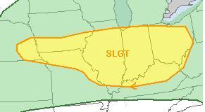 Large hail and damaging winds remain the main threat, though isolated tornadoes will be possible. Be sure to remain weather aware throughout the day!
239 PM CDT SAT JUL 26 2014
THE NATIONAL WEATHER SERVICE HAS CANCELLED SEVERE THUNDERSTORM WATCH 441 FOR THE FOLLOWING IOWA COUNTY: HARRISON .
SEVERE THUNDERSTORM WATCH 441…PREVIOUSLY IN EFFECT UNTIL 3 PM CDT THIS AFTERNOON…IS NOW IN EFFECT UNTIL 4 PM CDT THIS AFTERNOON FOR THE FOLLOWING AREAS
IN IOWA THIS WATCH INCLUDES 1 COUNTY: HARRISON
Currently, no other counties in western Iowa are under a Watch or warning.
THE NATIONAL WEATHER SERVICE HAS EXTENDED SEVERE THUNDERSTORM
WATCH 441 TO INCLUDE THE FOLLOWING AREAS UNTIL 3 PM CDT THIS AFTERNOON:
IN SOUTHWEST IOWA…HARRISON.
SEVERE THUNDERSTORM WATCH 441 REMAINS VALID UNTIL 3 PM CDT THIS AFTERNOON FOR THE FOLLOWING AREAS
IN IOWA THIS WATCH INCLUDES 1 COUNTY: IN WEST CENTRAL IOWA…MONONA


