
COUNTIES: SAC-CALHOUN-CRAWFORD-CARROLL-GREENE-BOONE-STORY-AUDUBON-GUTHRIE-DALLAS-CASS-ADAIR-MADISON-WARREN-ADAMS-UNION-CLARKE-LUCAS-TAYLOR-RINGGOLD-DECATUR-WAYNE-
512 AM CDT THU AUG 6 2015
…PATCHY FOG THIS MORNING THROUGH 8 AM CDT…
SOME PATCHY FOG IS BEING REPORTED EARLY THIS MORNING
THROUGHOUT PORTIONS OF CENTRAL AND SOUTHERN IOWA. MANY SITES
ARE REPORTING VISIBILITIES IN THE 2 TO 5 MILES RANGE WITH LIGHT
FOG. HOWEVER A FEW SITES HAVE VISIBILITIES REDUCED TO LESS THAN
ONE MILE AND EVEN NEAR ZERO. THEREFORE BE PREPARED FOR
VISIBILITIES TO BE QUICKLY REDUCED TO NEAR ZERO AT TIMES IN THE
PATCHY FOG…ESPECIALLY IN VALLEYS AND NEAR STREAMS AND OTHER LOW LYING AREAS.
354 AM CDT THU AUG 6 2015
TODAY…PARTLY SUNNY. PATCHY FOG THROUGH MID MORNING. HIGH IN THE LOWER 80S. SOUTH WIND NEAR 10 MPH.
TONIGHT…MOSTLY CLOUDY. A 20 PERCENT CHANCE OF THUNDERSTORMS OVERNIGHT. LOW IN THE UPPER 60S. SOUTH WIND 5 TO 10 MPH.
FRIDAY…MOSTLY SUNNY. HIGH IN THE UPPER 80S. SOUTHWEST WIND 5 TO 10 MPH SHIFTING TO THE NORTHWEST IN THE AFTERNOON.
FRIDAY NIGHT…PARTLY CLOUDY THROUGH MIDNIGHT…THEN MOSTLY CLOUDY WITH A 20 PERCENT CHANCE OF THUNDERSTORMS AFTER MIDNIGHT. LOW IN THE UPPER 60S. NORTHEAST WIND NEAR 10 MPH SHIFTING TO THE SOUTHEAST AFTER MIDNIGHT.
SATURDAY…CLOUDY WITH A 50 PERCENT CHANCE OF THUNDERSTORMS. HIGH IN THE LOWER 80S. SOUTHEAST WIND NEAR 10 MPH.
SATURDAY NIGHT…CLOUDY WITH A 50 PERCENT CHANCE OF THUNDERSTORMS. LOW IN THE UPPER 60S.
SUNDAY…MOSTLY CLOUDY WITH A 50 PERCENT CHANCE OF THUNDERSTORMS. HIGH IN THE LOWER 80S.
The Freese-Notis (podcast) weather forecast for Atlantic & the KJAN listening area, and weather information for Atlantic.

Podcast: Play in new window | Download (1.2MB)
Subscribe: RSS
Today: Mostly cloudy with a 50 percent chance of thunderstorms. High in the upper 70s. East wind 5 to 10 mph.
Tonight: Mostly cloudy then becoming partly cloudy after midnight then becoming mostly cloudy. A 20 percent chance of thunderstorms in the evening. Low in the mid 60s. East wind near 10 mph.
Thursday: Partly sunny. High in the lower 80s. East wind near 5 mph shifting to the southeast in the afternoon.
Thursday Night: Mostly cloudy with a chance of thunderstorms through midnight…then partly cloudy with a slight chance of thunderstorms after midnight. Low in the mid 60s. South wind near 10 mph. Chance of thunderstorms 40 percent.
Friday: Mostly sunny. High in the mid 80s.
Friday Night: Mostly cloudy. Low in the mid 60s.
Saturday: Partly sunny with a 20 percent chance of thunderstorms. High in the mid 80s.
The Freese-Notis (podcast) weather forecast for Atlantic & the KJAN listening area, and weather information for Atlantic.
Podcast: Play in new window | Download (1.2MB)
Subscribe: RSS
CRAWFORD-AUDUBON-CASS-ADAIR-ADAMS-UNION-TAYLOR-RINGGOLD COUNTIES….TUE AUG 4 2015
TODAY AND TONIGHT: THUNDERSTORMS ARE POSSIBLE THROUGHOUT THE DAY INTO THE OVERNIGHT. ALTHOUGH SEVERE WEATHER IS NOT ANTICIPATED…SOME OF THE STRONGER STORMS MAY PRODUCE SMALL HAIL AND BRIEF GUSTY WINDS.
WEDNESDAY THROUGH MONDAY: INTERMITTENT THUNDERSTORM CHANCES CONTINUE THROUGHOUT THE FORECAST PERIOD. STRONG TO SEVERE STORMS MAY BE POSSIBLE THURSDAY EVENING INTO FRIDAY MORNING. AT THIS TIME…THE SEVERE WEATHER THREAT REMAINS LOW FOR THE REST OF THE PERIOD.
.SPOTTER INFORMATION STATEMENT…
SPOTTER ACTIVATION MAY BE NEEDED THURSDAY NIGHT.
CARROLL-GUTHRIE-DALLAS-MADISON COUNTIES:
TODAY AND TONIGHT: NO HAZARDOUS WEATHER IS EXPECTED AT THIS TIME.
WEDNESDAY THROUGH MONDAY: INTERMITTENT THUNDERSTORM CHANCES CONTINUE THROUGHOUT THE FORECAST PERIOD. STRONG TO SEVERE STORMS MAY BE POSSIBLE THURSDAY EVENING INTO FRIDAY MORNING. AT THIS TIME…THE SEVERE WEATHER THREAT REMAINS LOW FOR THE REST OF THE PERIOD.
MONONA-HARRISON-SHELBY-POTTAWATTAMIE-MILLS-MONTGOMERY-FREMONT-PAGE COUNTIES…
601 AM CDT TUE AUG 4 2015
TODAY AND TONIGHT: SCATTERED AND ISOLATED STORMS WILL BE POSSIBLE THROUGH THE DAY AND INTO TONIGHT. A FEW STORMS MAY APPROACH SEVERE LEVELS DURING THIS TIME WITH LARGE HAIL AND DAMAGING WINDS THE PRIMARY HAZARDS.
WEDNESDAY THROUGH MONDAY: THERE IS A CHANCE OF THUNDERSTORMS THROUGH MUCH OF THE WEEK AND INTO THE WEEKEND AS SEVERAL WEATHER IMPULSES MOVE ACROSS THE REGION.
.SPOTTER INFORMATION STATEMENT…
SPOTTER ACTIVATION IS NOT EXPECTED TONIGHT OR TUESDAY…BUT
PLEASE PASS ALONG ANY REPORTS OF LARGE HAIL OR WIND DAMAGE.
Today: Partly sunny with a 20 percent chance of thunderstorms. High in the lower 80s. Southeast wind 5 to 10 mph.
Tonight: Mostly cloudy with a 50 percent chance of thunderstorms. Low in the mid 60s. Southeast wind around 5 mph.
Wednesday: Partly sunny. A chance of thunderstorms in the morning…then a slight chance of thunderstorms in the afternoon. High in the lower 80s. East wind 5 to 10 mph. Chance of thunderstorms 50 percent.
Wednesday Night: Mostly cloudy with a 20 percent chance of thunderstorms. Low in the mid 60s. East wind 5 to 10 mph.
Thursday: Partly sunny. High in the lower 80s.
Thursday Night: Mostly cloudy with a 40 percent chance of thunderstorms. Low in the mid 60s.
Friday: Partly sunny with a 20 percent chance of thunderstorms. High in the lower 80s.
Taken 10 miles south of Fontanelle. One mile south of the Adair-Adams Co. line. 110th and Sycamore. Referred to as “Williamson.”

Photo courtesy Mike Kennon
A National Weather Service survey team has given a preliminary estimate of a tornado Sunday night in Adams county as an EF-1, or “weak.” The 350-yard wide twister packed peak winds of 100 mph, with a path length of 4.2 miles. It began 9.1 miles north/northeast of Prescott at around 6:25-p.m. and headed south before turning east and ending 8.2-miles north/northeast of Prescott at around 6:50-p.m.
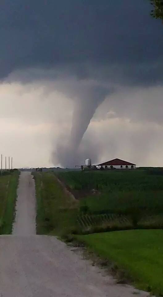
Photo via Iowa Storm Chaser Network’s Facebook page


