
Emergency Management officials in Shelby County say the field/grassland Fire Danger rating will remain “High,” this week. EMA Operations Officer Jason Wickizer says drying conditions, wind and abundant sunshine along with low humidity will make for dangerous fire conditions.
Anyone who plans to conduct controlled burns should contact their local fire chief, first. Be sure and call 755-2124 also, with the location of your burn, so dispatchers can gather logistical data. Burns should be conducted with fire chief approval during the late evening or early morning hours only, when winds are usually reduced.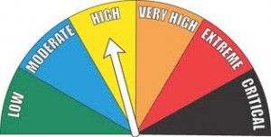
Early this morning: Partly cloudy, with a low around 33. Breezy, with a north northwest wind 14 to 16 mph, with gusts as high as 23 mph.
Monday: Sunny, with a high near 52. Breezy, with a north northwest wind 10 to 18 mph, with gusts as high as 26 mph.
Monday Night: Clear, with a low around 26. North northwest wind 8 to 13 mph becoming light and variable after midnight.
Tuesday: Sunny, with a high near 57. Light and variable wind becoming south 8 to 13 mph in the morning.
Wednesday: Sunny, with a high near 68.
Thursday: Sunny, with a high near 71. Breezy.
Sunday’s High in Atlantic was 65. Our Low this morning (as of 6:28-a.m.) was 28. Last year on this date we reached a High of 71, and the Low was 34. The all-time record High in Atlantic for this date, was 91 in 1996, while the record Low was 18 in 1956.
Early This Morning: Mostly cloudy. Breezy. Not as cool. South wind 15 to 20 mph.
Today: Mostly cloudy. Isolated thunderstorms through the day. Scattered light showers early in the afternoon. High in the mid 60s. Southwest wind 10 to 15 mph shifting to the north in the afternoon. Gusts up to 25 mph. Chance of precipitation 40 percent.
Tonight: Mostly cloudy in the evening then becoming partly cloudy. Colder. Low in the mid 30s. North wind 5 to 10 mph. Gusts up to 20 mph through midnight.
Monday: Sunny…breezy…cooler. High in the lower 50s. North wind 5 to 10 mph increasing to northwest 15 to 20 mph in the afternoon.
Tuesday: Sunny. High in the mid 50s. Southeast wind near 10 mph.
Wednesday: Mostly sunny. Warmer. High in the mid 60s.
…FREEZE WARNING IN EFFECT UNTIL 9 AM CDT THIS MORNING…
EARLY THIS MORNING…MOSTLY CLEAR. NORTHEAST WIND NEAR 5 MPH.
TODAY…SUNNY…BREEZY. HIGH 53. SOUTHEAST WIND 5 TO 10 MPH WITH GUSTS TO AROUND 20 MPH INCREASING TO 15 TO 20 MPH WITH GUSTS TO AROUND 30 MPH IN THE AFTERNOON.
TONIGHT…PARTLY CLOUDY UNTIL EARLY MORNING THEN BECOMING MOSTLY CLOUDY. A SLIGHT CHANCE OF SHOWERS AND ISOLATED THUNDERSTORMS EARLY IN THE MORNING. BREEZY. NOT AS COOL. LOW AROUND 44. SOUTH WIND 15 TO 20 MPH WITH GUSTS TO AROUND 30 MPH. CHANCE OF PRECIPITATION 20 PERCENT.
SUNDAY…MOSTLY CLOUDY. A CHANCE OF SHOWERS AND ISOLATED THUNDERSTORMS UNTIL LATE AFTERNOON…THEN A SLIGHT CHANCE OF SHOWERS AND ISOLATED THUNDERSTORMS LATE IN THE AFTERNOON. WARMER. HIGH 67. SOUTHWEST WIND 10 TO 15 MPH SHIFTING TO THE NORTHWEST IN THE AFTERNOON. GUSTS UP TO 25 MPH. CHANCE OF PRECIPITATION 40 PERCENT.
SUNDAY NIGHT…MOSTLY CLOUDY THROUGH MIDNIGHT THEN BECOMING PARTLY CLOUDY. LOW IN THE MID 30S. NORTH WIND 5 TO 10 MPH. GUSTS UP TO 20 MPH THROUGH MIDNIGHT.
MONDAY…SUNNY…COOLER. HIGH 52. NORTH WIND 5 TO 15 MPH WITH GUSTS TO AROUND 25 MPH.
TUESDAY…SUNNY. HIGH IN THE LOWER 50S.

Podcast: Play in new window | Download (694.6KB)
Subscribe: RSS
Iowa homeowners who have tulips, daffodils, newly-planted trees and other tender plants poking up in their yards will need to get busy this (Friday) afternoon to save them. Meteorologist Craig Cogil, at the National Weather Service, says a Freeze Warning is posted for a wide portion of Iowa, roughly from Highway 20 south. “We’re going to see temperatures drop well below freezing overnight across the entire state,” Cogil says. “We are concerned about some of the trees and vegetation across the southern half to two-thirds of the state that have seen growth and are susceptible to freezing temperatures.”
Many areas of the state may see temperatures dip into the low-to-mid-20s tonight and into tomorrow morning. Homeowners will need to act to keep their plants from being nipped or possibly killed by the overnight cold snap. “Individuals in those situations, obviously, if you have smaller plants, cover them up, that helps out,” Cogil says. “People that have orchards will have mitigation techniques they use. The main thing is to get them covered up.”
We’re a couple of weeks into spring now but Cogil says this isn’t an unusual situation. “Some years, especially if you look back at 2012, had an extremely warm March, everything was ahead as far as growing was concerned,” Cogil says. “We saw that a little bit in March where temperatures were warm and things are maybe a little bit ahead of normal, but this is not entirely unusual.”
Some areas of northern Iowa are seeing flurries fly this morning and while it’ll be a cold weekend, Cogil predicts the sparse snow won’t accumulate.
(Radio Iowa)
Today: Partly Cloudy to Cloudy. High 54. NW @ 15-30.
Tonight: Mostly Clear. Low 22. Winds light & variable.
Tomorrow: *Freeze warning from 1-am until 9-a.m. Saturday*
P/Cldy. High 56. S @ 10-15.
Sunday: P/Cldy to Cldy w/scattered showers & thunderstorms. High 68.
Monday: Mo. Cldy. High 54.
Thursday’s High in Atlantic was 54. The Low thru 7-a.m. today was 26. Last year on this date, our High in Atlantic was 50 and the low was 41. The All-time Record High in Atlantic on this date was 89 in 1931. The Record Low was 16 in 1956.
Today: Sunny…breezy. High around 50. Northwest wind 10 to 15 mph increasing to 20 to 25 mph in the afternoon. Gusts up to 35 mph.
Tonight: Mostly clear. Low in the mid 20s. North wind 10 to 15 mph with gusts to around 30 mph becoming northeast up to 5 mph after midnight. **FREEZE WARNING in effect 1-a.m. Saturday until 9-a.m. Saturday**
Saturday: Mostly sunny. High in the lower 50s. Southeast wind 5 to 15 mph. Gusts up to 25 mph in the afternoon.
Saturday Night: Partly cloudy through midnight…then mostly cloudy with a slight chance of showers and isolated thunderstorms after midnight. Breezy. Not as cool. Low in the lower 40s. South wind 15 to 20 mph. Chance of precipitation 20 percent.
Sunday: Cloudy with a chance of showers and isolated thunderstorms. Warmer. High in the upper 60s. Chance of precipitation 40 percent.
Monday: Mostly sunny. Cooler. High in the mid 50s.
AREA COUNTIES: CRAWFORD-CARROLL-AUDUBON-GUTHRIE-DALLAS-CASS-ADAIR-MADISON-ADAMS-UNION-TAYLOR-RINGGOLD-MONONA-HARRISON-SHELBY-POTTAWATTAMIE-MILLS-MONTGOMERY-FREMONT-
PAGE…..334 AM CDT FRI APR 8 2016
THE NATIONAL WEATHER SERVICE IN DES MOINES HAS ISSUED A FREEZE WARNING…WHICH IS IN EFFECT FROM 1 AM TO 9 AM CDT SATURDAY. THE FREEZE WATCH IS NO LONGER IN EFFECT.
* TEMPERATURE…TEMPERATURES WILL FALL TO THE LOWER TO MIDDLE 20S DURING THE OVERNIGHT HOURS TONIGHT INTO SATURDAY MORNING.
* IMPACTS…TENDER VEGETATION MAY BE KILLED OR DAMAGED BY THE COLD TEMPERATURES AND RESULTANT FREEZE.
PRECAUTIONARY/PREPAREDNESS ACTIONS…
A FREEZE WARNING MEANS SUB-FREEZING TEMPERATURES ARE IMMINENT OR HIGHLY LIKELY. THESE CONDITIONS WILL KILL CROPS AND OTHER SENSITIVE VEGETATION.
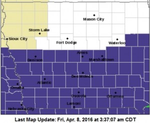
Freeze Waring for all counties in purple Friday night & Sat. morning
SAC-CALHOUN-CRAWFORD-CARROLL-AUDUBON-CASS-ADAMS-TAYLOR-MONONA-HARRISON-SHELBY-POTTAWATTAMIE-MILLS-MONTGOMERY-FREMONT-PAGE-GUTHRIE-DALLAS-ADAIR-MADISON-UNION-RINGGOLD COUNTIES IN IA…340 PM CDT THU APR 7 2016
A FREEZE WATCH WILL BE IN EFFECT FROM LATE FRIDAY NIGHT THROUGH SATURDAY MORNING. LOW TEMPERATURES SATURDAY MORNING COULD REACH THE MID AND UPPER 20S FOR SEVERAL HOURS. A FREEZE WATCH MEANS SUB-FREEZING TEMPERATURES ARE POSSIBLE. THESE CONDITIONS COULD KILL CROPS AND OTHER SENSITIVE VEGETATION.
AREA COUNTIES: GUTHRIE-DALLAS-ADAIR-MADISON-UNION-RINGGOLD-
1240 PM CDT THU APR 7 2016
…STRONG WINDS AND SMALL HAIL WITH SHOWERS THIS AFTERNOON…
NUMEROUS SHOWERS AND A FEW ISOLATED THUNDERSTORMS WILL MOVE ACROSS SOUTH CENTRAL TO SOUTHWEST IOWA THIS AFTERNOON. THESE SHOWERS COULD BRING LOCALLY STRONG WINDS WITH GUSTS OF 40 TO 50 MPH AND PEA TO DIME SIZE HAIL. MOTORISTS AND THOSE OUTSIDE SHOULD BE ALERT TO CHANGING WEATHER CONDITIONS AROUND THESE SHOWERS THROUGH THE MID TO LATE AFTERNOON HOURS.


