
Today: Showers and thunderstorms likely, mainly after 5pm. Some of the storms could be severe. Mostly cloudy, with a high near 86. South wind 5 to 10 mph.
Tonight: Showers and thunderstorms likely, mainly before midnight. Some of the storms could be severe. Becoming Partly cloudy. Low around 70.
Wednesday: Partly cloudy. High near 90. West northwest wind 10 to 15 mph.
Wednesday Night: Clear, with a low around 66.
Thursday: P/Cldy. High near 91. East wind 5 to 10 mph.
Friday: P/Cldy w/isolated showers & tstrms possible. High near 91.
Monday’s High in Atlantic was 91. Our 24-hour Low thru 7-a.m. today was 69. We received .12” of rain Monday evening. Last year on this date, our High in Atlantic was 82 and the low was 65. The All-time Record High in Atlantic on this date was 97 in 1987. The Record Low was 41 in 1933.
EARLY THIS MORNING…MOSTLY CLOUDY. SOUTHEAST WIND NEAR 5 MPH.
TODAY…A CHANCE OF THUNDERSTORMS THROUGH MID MORNING…THEN THUNDERSTORMS LIKELY IN THE LATE MORNING AND AFTERNOON. HIGH IN THE UPPER 80S. SOUTH WIND 5 TO 15 MPH. CHANCE OF THUNDERSTORMS 60 PERCENT.
TONIGHT…MOSTLY CLOUDY WITH THUNDERSTORMS LIKELY IN THE EVENING…THEN PARTLY CLOUDY WITH A CHANCE OF THUNDERSTORMS BEFORE MIDNIGHT AND EARLY MORNING. MOSTLY CLEAR EARLY IN THE MORNING. LOW IN THE UPPER 60S. SOUTHWEST WIND 5 TO 10 MPH. CHANCE OF THUNDERSTORMS 60 PERCENT.
WEDNESDAY…SUNNY. HIGH IN THE LOWER 90S. WEST WIND 5 TO 10 MPH.
THURSDAY…SUNNY. HIGH IN THE LOWER 90S. EAST WIND 5 TO 10 MPH.
FRIDAY…MOSTLY SUNNY. HIGH IN THE UPPER 80S.
Today: Partly cloudy w/a 40% chance of showers & thunderstorms this afternoon. High 90. SE @ 10-20.
Tonight: P/Cldy w/a 40% chance of showers & tstrms. Low 72 SE @ 5-10.
Tomorrow: Cloudy w/a 70% chance of showers & tstorms. High 86. SE @ 10-15.
Tom. Night: P/Cldy to Cldy w/a 60% chance of showers & thunderstorms. Low around 68. .
Wednesday: P/Cldy w/showers & tstrms ending early. High near 90. .
Thursday: P/Cldy. High near 90.
Sunday’s High in Atlantic was 93. Our 24-hour Low thru 7-a.m. today was 71. Last year on this date, our High in Atlantic was 76 and the low was 62. The All-time Record High in Atlantic on this date was 96 in 1987. The Record Low was 37 in 1906.
Early this morning: Partly cloudy. Low in the lower 70s. South wind around 5 mph.
Today: Partly sunny with a 50 percent chance of thunderstorms. High in the upper 80s. Southwest wind around 5 mph.
Tonight: Mostly cloudy with a 50 percent chance of thunderstorms. Low in the lower 70s. Southeast wind around 5 mph.
Tuesday: Thunderstorms. High in the mid 80s. Southeast wind 5 to 10 mph shifting to the south around 15 mph in the afternoon. Chance of thunderstorms 80 percent.
Tuesday Night: Mostly cloudy with thunderstorms likely through midnight…then partly cloudy with a slight chance of thunderstorms after midnight. Low in the upper 60s. South wind 5 to 15 mph. Chance of thunderstorms 60 percent.
Wednesday: Sunny. High in the upper 80s.
Thursday: Sunny. High in the lower 90s.
Today: Sunny, with a high near 93. South wind 5 to 10 mph.
Tonight: Partly cloudy, with a low around 71. South wind 5 to 10 mph.
Monday: Partly Sunny w/a 50% chance of showers and thunderstorms, mainly after 1pm. High near 88. S/SW winds 5-10mph. New rainfall amounts between a tenth and quarter of an inch, except higher amounts possible in thunderstorms.
Monday Night: Mostly cloudy w/a 40% chance of showers and thunderstorms. Low around 68. New rainfall amounts between a tenth and quarter of an inch, except higher amounts possible in thunderstorms.
Tuesday: Mostly Cloudy w/a 70% chance of Showers and thunderstorms. High near 86. S @ 10-20mph. New rainfall amounts between a half and three quarters of an inch possible.
Tuesday Night: Showers and thunderstorms likely. Low around 68. Wednesday: Mostly sunny, with a high near 87.
Saturday’s High in Atlantic was 93. Our 24-hour Low thru 7-a.m. today was 71. Last year on this date, our High in Atlantic was 67 and the low was 60. The All-time Record High in Atlantic on this date was 95 in 1892. The Record Low was 38 in 1903.
507 AM CDT SUN JUN 12 2016
EARLY THIS MORNING…MOSTLY CLEAR. SOUTH WIND NEAR 5 MPH.
TODAY…SUNNY. HIGH IN THE LOWER 90S. SOUTH WIND 5 TO 15 MPH.
TONIGHT…PARTLY CLOUDY. A 20 PERCENT CHANCE OF THUNDERSTORMS EARLY IN THE MORNING. LOW IN THE LOWER 70S. SOUTH WIND 5 TO 10 MPH.
MONDAY…MOSTLY SUNNY IN THE MORNING THEN BECOMING MOSTLY CLOUDY. A 50 PERCENT CHANCE OF THUNDERSTORMS. HIGH IN THE UPPER 80S. SOUTHWEST WIND 5 TO 10 MPH.
MONDAY NIGHT…MOSTLY CLOUDY WITH A 50 PERCENT CHANCE OF THUNDERSTORMS. LOW IN THE UPPER 60S. EAST WIND AROUND 5 MPH.
TUESDAY…THUNDERSTORMS LIKELY. HIGH IN THE MID 80S. SOUTHEAST WIND 5 TO 15 MPH. GUSTS UP TO 25 MPH IN THE AFTERNOON. CHANCE OF THUNDERSTORMS 70 PERCENT.
TUESDAY NIGHT…THUNDERSTORMS LIKELY. LOW IN THE UPPER 60S. CHANCE OF THUNDERSTORMS 70 PERCENT.
WEDNESDAY…MOSTLY SUNNY. HIGH IN THE UPPER 80S.
DES MOINES, Iowa (AP) — It looks to be a miserably hot weekend in parts of Iowa and Nebraska this weekend. The National Weather Service has issued a heat advisory for Des Moines and central and northern parts of Nebraska and Iowa.
The service says temperature in the mid to upper 90s, combined with high humidity, will send heat index values into the triple digits in Nebraska on Saturday. The heat advisory will remain in effect for Des Moines and other parts of Iowa through Sunday evening.
The service cautions people in the advisory areas to drink plenty of fluids, stay out of the sun and stay in an air-conditioned room, if possible.
SPENCER, Iowa (AP) — Residents in northwest Iowa are cleaning up this weekend after a series of strong thunderstorms knocked down tree limbs and caused power outages Friday night. The Sioux City Journal reports Sioux, Osceola, Dickinson, O’Brien, Cherokee and Clay counties are among the areas hit by high wind gusts and large hail.
The sheriff’s offices in Dickinson and Osceola counties reported down tree limbs and power outages. Alex Ferguson with the National Weather Service in Sioux Falls says wind gusts sometimes exceeding 60 mph were recorded in several counties. The highest, at 67 mph, was recorded at 9:14 p.m. at the Spencer Airport.
Ferguson says golf-ball-sized hail was reported around 8 p.m. in Dickinson County.
Today: Sunny, with a high near 96. Heat index values as high as 101. South southwest wind 8 to 11 mph.
Tonight: Mostly clear, with a low around 71. South wind 7 to 10 mph.
Sunday: Sunny, with a high near 94. South wind 7 to 14 mph, with gusts as high as 18 mph.
Sunday Night: A 20 percent chance of showers and thunderstorms after 1am. Mostly clear, with a low around 71. South wind 5 to 10 mph.
Monday: A 50 percent chance of showers and thunderstorms. Partly sunny, with a high near 88. Southwest wind around 6 mph. New rainfall amounts between a tenth and quarter of an inch, except higher amounts possible in thunderstorms.
Monday Night: A 40 percent chance of showers and thunderstorms. Mostly cloudy, with a low around 69. New rainfall amounts of less than a tenth of an inch, except higher amounts possible in thunderstorms.
Tuesday: Showers and thunderstorms likely. Mostly cloudy, with a high near 85. Chance of precipitation is 60%.
Friday’s High in Atlantic was 94. Our Low this morning was 73. Last year on this date, our High in Atlantic was 68 and the low was 60. The All-time Record High in Atlantic on this date was 99 in 1892. The Record Low was 36 in 1903.
The National Weather Service has placed more than a dozen counties in northwest and central Iowa under a heat advisory through Sunday. Temperatures are expected to reach the upper 90s, while heat indices could climb into the triple digits in Sioux City, Spencer, Des Moines, Ames, and surrounding cities. Staci Schweder, a nurse with Mercy Medical in Sioux City, says anyone spending time outdoors should drink plenty of water.
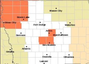
Heat Advisory (counties in Orange) until 9-p.m. Saturday for n.w. IA, & until 7-p.m. Sunday for parts of central IA
“Be proactive with that. Start drinking (water) right away in the morning and continue to drink throughout the day,” Schweder says. While staying hydrated is key to avoiding heat exhaustion, Schweder suggests wearing light, loose-fitting clothing and taking plenty of breaks from the sun as well. She also recommends using wet washcloths or towels on the neck or forearms to keep cool. The warning signs of heat stroke include feeling faint or nauseated.
“Heart racing…cool, clammy skin…if those start to happen, you definitely want to find shade and get to a cooler environment,” Schweder says. Some relief from the heat may arrive over northeast Iowa Sunday. The forecast calls for the possibility of some thunderstorms over northern Iowa tonight (Friday) and over northern and central Iowa Saturday. The National Weather Service reports wetter and cooler conditions are expected early next week.
(Radio Iowa)


