
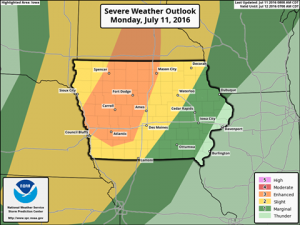
The Severe Storms Prediction Center in Norman, OK., has issued an Enhanced Risk of severe storms across portions of western and central Iowa for storms expected mainly this evening/overnight. Large hail and damaging winds are the main severe threats. Pay attention to the latest forecast for updates through the day/night on KJAN and on our Facebook and Twitter feeds.
Monday, July 11th 2016 Dan Hicks
Today: P/Cldy, warm & humid. High 92. SW @ 10-20.
Tonight: P/Cldy to Cldy shwrs & tstrms. (Severe weather is possible) Low 73. S @ 5-10.
Tomorrow: Shwrs & tstrms early; Becoming P/Cldy. High 89. SE @ 10-15.
Wednesday: P/Cldy to Cldy w/scatt. Shwrs & tstrms. High 87.
Thursday: P/Cldy. Less humid. High around 85.
Sunday’s High in Atlantic was 87. Our 24-hour Low thru 7-a.m. today was 72. Last year on this date, our High in Atlantic was 80 and the low was 67. The All-time Record High in Atlantic on this date was 104 in 1936. The Record Low was 43 in 1895.
SAC-CRAWFORD-CARROLL-AUDUBON-GUTHRIE-DALLAS-CASS-ADAIR-MADISON-ADAMS-UNION-TAYLOR-RINGGOLD COUNTIES….
TODAY AND TONIGHT: THUNDERSTORMS ARE EXPECTED TO MOVE ACROSS THE AREA THIS EVENING AND INTO THE OVERNIGHT. A FEW STORMS MAY BE SEVERE WITH DAMAGING WIND GUSTS IN EXCESS OF 60 MPH AND HALF DOLLAR SIZED HAIL. THE STRONGEST STORMS ARE EXPECTED BETWEEN 7 PM AND MIDNIGHT. LOCALLY HEAVY RAINFALL MAY OCCUR.
ADDITIONAL THUNDERSTORMS ARE POSSIBLE TUESDAY AND WEDNESDAY WITH A FEW SEVERE STORMS AND LOCALLY HEAVY RAINFALL POSSIBLE. ADDITIONAL THUNDERSTORMS ARE FORECAST FOR NEXT WEEKEND.
SPOTTER INFORMATION STATEMENT… SPOTTER ACTIVATION MAY BE NEEDED AT TIMES TONIGHT THROUGH WEDNESDAY.
MONONA-HARRISON-SHELBY-POTTAWATTAMIE-MILLS-MONTGOMERY-FREMONT-PAGE COUNTIES IN IA; MON JUL 11 2016
TODAY AND TONIGHT: SEVERE THUNDERSTORMS ARE POSSIBLE THIS AFTERNOON AND EVENING AS A COLD FRONT MOVES INTO THE AREA. LARGE HAIL…DAMAGING WINDS AND ISOLATED TORNADOES ARE ALL POSSIBLE.
THUNDERSTORMS ARE FORECAST TO DEVELOP IN NORTHEAST NEBRASKA BY MID AFTERNOON…THEN SPREAD SOUTH AND EAST ACROSS THE REST OF EASTERN NEBRASKA AND SOUTHWEST IOWA LATE THIS AFTERNOON AND EVENING. SUFFICIENT INSTABILITY AND SHEAR PARAMETERS WILL EXIST FOR SUPERCELL STORMS THAT WILL BE CAPABLE OF PRODUCING ALL MODES OF SEVERE WEATHER. THE STORMS ARE EXPECTED TO MERGE INTO CLUSTERS OR LINES BY LATE EVENING WHEN TRAINING OF STORMS COULD PRODUCE LOCALLY HEAVY RAINFALL OF GREATER THAN 2 INCHES…LIKELY OVER SOUTHEAST NEBRASKA AND SOUTHWEST IOWA.
THE THREAT OF SEVERE WEATHER SHOULD BE ENDING BY MID EVENING IN
NORTHEAST NEBRASKA…BUT COULD PERSIST PAST MIDNIGHT IN EAST
CENTRAL AND SOUTHEAST NEBRASKA…AS WELL AS ALL OF SOUTHWEST IOWA. BEFORE THE THE RAIN ARRIVES…ANOTHER HOT AND HUMID DAY IS
EXPECTED WITH AFTERNOON HEAT INDEX VALUES INCREASING TO 100 TO 105 DEGREES ALONG AND SOUTH OF INTERSTATE 80.
TUESDAY/WEDNESDAY: THERE IS A CHANCE FOR SEVERE THUNDERSTORMS AGAIN ON TUESDAY AND WEDNESDAY…MAINLY SOUTH OF INTERSTATE 80. THE COLD FRONT MOVING THROUGH MONDAY NIGHT IS FORECAST TO STALL JUST SOUTH OF THE AREA EARLY TUESDAY…THEN SURGE BACK NORTH INTO OUR AREA TUESDAY AFTERNOON AND WEDNESDAY. ADDITIONAL THUNDERSTORMS ARE POSSIBLE EACH DAY FRIDAY THROUGH
SUNDAY.
SPOTTER INFORMATION STATEMENT: SPOTTER ACTIVATION MAY BE NEEDED THIS AFTERNOON AND EVENING.
352 AM CDT MON JUL 11 2016
EARLY THIS MORNING…MOSTLY CLEAR. SOUTH WIND 10 TO 15 MPH.
TODAY…MOSTLY SUNNY. HOT AND HUMID. BREEZY. HIGH AROUND 90. SOUTH WIND 15 TO 25 MPH. HIGHEST HEAT INDEX READINGS AROUND 100 IN THE AFTERNOON.
TONIGHT…THUNDERSTORMS LIKELY. BREEZY. LOW IN THE LOWER 70S. SOUTH WIND 15 TO 20 MPH WITH GUSTS TO AROUND 30 MPH DECREASING TO 5 TO 15 MPH AFTER MIDNIGHT. CHANCE OF THUNDERSTORMS 70 PERCENT.
TUESDAY…MOSTLY CLOUDY UNTIL LATE AFTERNOON THEN BECOMING MOSTLY SUNNY. THUNDERSTORMS LIKELY THROUGH MID MORNING…THEN A CHANCE OF THUNDERSTORMS IN THE LATE MORNING AND AFTERNOON. HIGH IN THE MID 80S. SOUTHWEST WIND 5 TO 10 MPH. CHANCE OF THUNDERSTORMS 70 PERCENT.
TUESDAY NIGHT…PARTLY CLOUDY WITH A 40 PERCENT CHANCE OF THUNDERSTORMS. LOW IN THE UPPER 60S. SOUTHWEST WIND 5 TO 10 MPH.
WEDNESDAY...SUNNY IN THE MORNING THEN BECOMING PARTLY SUNNY. A 20 PERCENT CHANCE OF THUNDERSTORMS. HIGH IN THE MID 80S. WEST WIND 5 TO 10 MPH.
Today: A slight chance of showers and thunderstorms between 1pm and 2pm. Mostly sunny, with a high near 89. Breezy, with a south wind 13 to 16 mph, with gusts as high as 24 mph. Chance of precipitation is 20%.
Tonight: Mostly clear, with a low around 73. Breezy, with a south wind 11 to 16 mph, with gusts as high as 23 mph.
Monday: Sunny, with a high near 91. Windy, with a south wind 14 to 23 mph, with gusts as high as 31 mph.
Monday Night: Showers and thunderstorms likely after 8pm. Increasing clouds, with a low around 72. Breezy, with a south wind 10 to 18 mph, with gusts as high as 26 mph. Chance of precipitation is 70%. New rainfall amounts between a half and three quarters of an inch possible.
Tuesday: Showers and thunderstorms likely, mainly before 8am. Mostly cloudy, with a high near 86. Southwest wind 8 to 10 mph. Chance of precipitation is 70%. New rainfall amounts between a quarter and half of an inch possible.
Tuesday Night: A 30 percent chance of showers and thunderstorms, mainly before 8pm. Partly cloudy, with a low around 67. New rainfall amounts of less than a tenth of an inch, except higher amounts possible in thunderstorms.
Wednesday: A 20 percent chance of showers and thunderstorms. Mostly sunny, with a high near 86.
Today: Mostly sunny, with a high near 89. South wind 10-20mph.
Tonight: Mostly clear & breezy, with a low around 73. South wind 10-20 gusts as high as 25 mph.
Monday: Mostly sunny & windy. High near 91. South wind 15 to 30mph.
Monday Night: A 70% chance of showers & thunderstorms. Low around 72. S @ 10-25. New rainfall amounts between three quarters and one inch possible.
Tuesday: Mostly cloudy w/a 40% chance of showers & thunderstorms. High near 86. S/SW @ 5-10. New rainfall amounts between a quarter and half of an inch possible.
Wednesday: Mosty sunny w/a slight chance of showers and thunderstorms. High near 86.
Today: Mostly Sunny. High 86. E/SE @ 5-10.
Tonight: Mo. Clear. Low 65. E/SE @ 5-10.
Tomorrow: Mo. Sunny. High 90. S @ 15-20.
Tom. Night: P/Cldy. Low 74/
Monday: P/Sunny. High 92.
Tuesday: P/Sunny w/isolated thundershowers. High around 90.
Friday’s High in Atlantic was 85. Our 24-hour Low thru 7-a.m. today was 59. Last year on this date, our High in Atlantic was 81 and the low was 60. The All-time Record High in Atlantic on this date was 104 in 1930. The Record Low was 37 in 1895.
You can thank reserves built up at the end of last year for keeping Iowa in good shape water wise following a dry June. The areas impacted by drought have increased in the most recent report, but Tim Hall with the Iowa Department of Natural Resources says it could be a lot worse. “If you ignored the fall of 2015, we would be in a bit of jam right now. It’s been somewhat dry — especially in parts of the state — but I think we’re still benefiting from the really wet November and December we had, given the rainfall that’s fallen in this first half of the year,” Hall says.
The Iowa average streamflow index dropped below the normal line on July 4th. Hall says the level is tracked on a daily basis and it has been above normal since May of 2015. “That speaks more to how wet it has been recently than how dry it is now,” Hall says. “So that index has just now gotten down to the normal line…so it mostly tells us how wet it has been for quite awhile.” Parts of the state have moved into moderate drought conditions, but Hall is not worried.
“We’re a long ways away from being overly concerned,” he says. The moderate drought level is the first level, and Hall says it could easily turn around. “It’s a pretty short-term deal, because if you look a the long-term climate prediction information — there’s not long term drought predicted for that part of the state out through the end of September,” Hall explains. “So, even the climate folks are looking at this as a short-term impact.” Areas of the state have struggled with low water levels in the last few years appear to be doing okay now.
“Part of the state where we’ve been consistently concerned has been in the northwest corner of the state. And they have actually done pretty well precipitation wise this year,” Hall says. “So, if there was any part of the state where we would want to be particularly concerned it would be up there. But they’ve been running in the first half of the year much about normal for rainfall. So, they are in pretty good shape.” Hall says swings in weather pattern can always make a difference in the water situation.
“You’re always on that sort of razor’s edge between too wet and too dry. For quite awhile in the state we’ve been really running right down the middle where we want to be. And really, that’s where we are right now,” according to Hall. You can find out more about Iowa’s water trends at: www.iowadnr.gov/watersummaryupdate.
(Radio Iowa)


