
SAC-CRAWFORD-CARROLL-AUDUBON-GUTHRIE-DALLAS-CASS-ADAIR-MADISON-ADAMS-UNION-TAYLOR and RINGGOLD COUNTIES:
STRONG TO SEVERE THUNDERSTORMS ARE EXPECTED TODAY AND THIS EVENING. DAMAGING WINDS AND LARGE HAIL WILL BE POSSIBLE. LOCALLY HEAVY RAINFALL WILL OCCUR NEAR THE STRONGEST THUNDERSTORMS. ADDITIONAL THUNDERSTORMS ARE POSSIBLE FRIDAY AND THIS WEEKEND.
SPOTTER ACTIVATION MAY BE NEEDED THIS AFTERNOON AND THIS EVENING.
MONONA-HARRISON-SHELBY-POTTAWATTAMIE-MILLS-MONTGOMERY-FREMONT-PAGE COUNTIES:
THERE WILL BE A CHANCE OF THUNDERSTORMS ACROSS THE AREA THIS
MORNING AND AGAIN BY MID TO LATE AFTERNOON AS A COLD FRONT MOVES THROUGH THE AREA. A FEW SEVERE STORMS ARE POSSIBLE WITH LARGE HAIL AND DAMAGING WINDS THE PRIMARY HAZARDS.
Today: Scattered showers and thunderstorms, mainly after 2pm. Partly sunny, with a high near 87. South wind 6 to 8 mph becoming west in the afternoon. Chance of precipitation is 30%. New rainfall amounts of less than a tenth of an inch, except higher amounts possible in thunderstorms.
Tonight: A 20 percent chance of showers and thunderstorms before 1am. Partly cloudy, with a low around 64. West wind 3 to 8 mph.
Thursday: Sunny, with a high near 84. Northwest wind 5 to 10 mph.
Friday: A 20 percent chance of showers and thunderstorms. Mostly sunny, with a high near 80. North northeast wind 5 to 7 mph.
Saturday: A 30 percent chance of showers and thunderstorms. Partly sunny, with a high near 81.
Tuesday’s High in Atlantic was 85. Our Low this morning was 65. Last year on this date, our High in Atlantic was 91 and the low was 67. The All-time Record High in Atlantic on this date was 108 in 1936. The Record Low was 44 in 1897.
Today: Partly Cloudy. High 88. Variable breeze @ 5-10mph.
Tonight: P/Cldy to Cloudy scattered showers & thunderstorms. Low 70. SE @ 5-10.
Tomorrow: P/Cldy to Cldy w/scattered shwrs & tstrms. High 88. SE @ 10-15.
Thursday: P/Cldy. High 83.
Friday: P/Cldy to Cldy w/isolated showers. High around 81.
Monday’s High in Atlantic was 90. Our Low this morning thru 5-a.m., was 64. We received 1.25” of rain overnight through early this morning. Last year on this date, our High in Atlantic was 80 and the low was 67. The All-time Record High in Atlantic on this date was 104 in 1936. The Record Low was 43 in 1895.
337 AM CDT TUE JUL 12 2016
EARLY THIS MORNING…CLOUDY WITH SCATTERED THUNDERSTORMS. COOLER. SOUTHWEST WIND 5 TO 10 MPH. CHANCE OF THUNDERSTORMS 50 PERCENT.
TODAY…PARTLY SUNNY. ISOLATED THUNDERSTORMS LATE IN THE AFTERNOON. HIGH IN THE UPPER 80S. NORTHWEST WIND AROUND 5 MPH. CHANCE OF THUNDERSTORMS 20 PERCENT.
TONIGHT…PARTLY CLOUDY WITH A 40 PERCENT CHANCE OF THUNDERSTORMS. LOW AROUND 70. SOUTH WIND AROUND 5 MPH.
WEDNESDAY…PARTLY SUNNY WITH A 50 PERCENT CHANCE OF THUNDERSTORMS. HIGH IN THE UPPER 80S. SOUTHWEST WIND 5 TO 10 MPH.
WEDNESDAY NIGHT…PARTLY CLOUDY WITH A 50 PERCENT CHANCE OF THUNDERSTORMS. LOW IN THE MID 60S. NORTHWEST WIND NEAR 10 MPH.
THURSDAY…SUNNY. HIGH IN THE LOWER 80S. NORTHWEST WIND 5 TO 10 MPH.
FRIDAY…MOSTLY SUNNY WITH A 20 PERCENT CHANCE OF THUNDERSTORMS. HIGH AROUND 80.
THE NATIONAL WEATHER SERVICE WILL ALLOW SEVERE THUNDERSTORM WATCH 372 TO EXPIRE AT 11 PM CDT THIS EVENING FOR THE FOLLOWING AREAS…IN IOWA THIS ALLOWS TO EXPIRE THE WATCH FOR AUDUBON CALHOUN CARROLL CRAWFORD GREENE SAC COUNTIES.
SEVERE THUNDERSTORM WATCH OUTLINE UPDATE FOR WS 373
NWS STORM PREDICTION CENTER NORMAN OK
1003 PM CDT MON JUL 11 2016
SEVERE THUNDERSTORM WATCH 373 IS NO LONGER IN EFFECT. THE WATCH HAD COVERED HARRISON MONONA POTTAWATTAMIE and SHELBY COUNTIES.
GUTHRIE IA-AUDUBON IA-CASS IA-CARROLL IA-ADAIR IA-GREENE IA–
945 PM CDT MON JUL 11 2016
…LINE OF STORMS MAY PRODUCE WIND GUSTS OF 40 TO 50 MPH…
AT 944 PM CDT…DOPPLER RADAR WAS TRACKING STRONG THUNDERSTORMS ALONG A LINE EXTENDING FROM NEAR COON RAPIDS TO 8 MILES NORTHEAST OF ATLANTIC. MOVEMENT WAS EAST AT 40 MPH. WIND GUSTS UP TO 50 MPH WILL BE POSSIBLE WITH THESE STORMS.
LOCATIONS IMPACTED INCLUDE…
AUDUBON…GUTHRIE CENTER…COON RAPIDS…LAKE PANORAMA…ANITA… EXIRA…ADAIR…ELK HORN…BAYARD…CASEY…KIMBALLTON…BAGLEY… DEDHAM…YALE…BRAYTON…SPRINGBROOK STATE PARK AND AUDUBON COUNTY AIRPORT.
A SEVERE THUNDERSTORM WATCH REMAINS IN EFFECT UNTIL 1100 PM CDT FOR WEST CENTRAL IOWA.
SEVERE THUNDERSTORM WATCH 372 REMAINS IN EFFECT UNTIL 1100 PM CDT FOR THE FOLLOWING AREA COUNTIES: AUDUBON CARROLL CRAWFORD SAC.
345 PM CDT MON JUL 11 2016
SEVERE THUNDERSTORM WATCH 372 IS IN EFFECT UNTIL 1000 PM CDT
FOR THE FOLLOWING LOCATIONS: IOWA COUNTIES INCLUDED ARE
BUENA VISTA CALHOUN CARROLL CHEROKEE CLAY CRAWFORD DICKINSON EMMET HUMBOLDT IDA KOSSUTH LYON O’BRIEN OSCEOLA PALO ALTO PLYMOUTH POCAHONTAS SAC SIOUX WEBSTER WOODBURY.
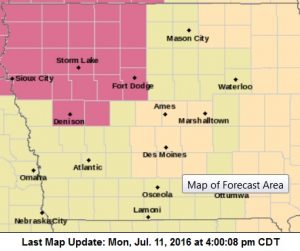
Watch #372. Counties in purple.
* PRIMARY THREATS INCLUDE…
SCATTERED LARGE HAIL AND ISOLATED VERY LARGE HAIL EVENTS TO 2
INCHES IN DIAMETER POSSIBLE.
SCATTERED DAMAGING WIND GUSTS TO 70 MPH POSSIBLE.
A TORNADO OR TWO POSSIBLE.
PROBABILITY TABLE:
PROB OF 2 OR MORE TORNADOES : 20%
PROB OF 1 OR MORE STRONG /F2-F5/ TORNADOES : 05%
PROB OF 10 OR MORE SEVERE WIND EVENTS : 50%
PROB OF 1 OR MORE WIND EVENTS > 75 MPH : 20%
PROB OF 10 OR MORE SEVERE HAIL EVENTS : 40%
PROB OF 1 OR MORE HAIL EVENTS > 2 INCHES : 30%
PROB OF 6 OR MORE COMBINED SEVERE HAIL/WIND EVENTS : 90%


