
Skyscan Forecast Monday, June 19, 2017 Dan Hicks
Today: Partly cloudy. NW @ 10-20. High 82.
Tonight: Mostly clear. Light and variable. Low 55.
Tuesday: Partly cloudy. W @ 10-15. High 85.
Wednesday: Partly cloudy. Warmer. High 90.
Thursday: Variable cloudiness. Scattered showers and thunderstorms. High 87.

Podcast: Play in new window | Download (495.2KB)
Subscribe: RSS
OMAHA, Neb. (AP) — Four tornadoes have been confirmed in the storms that hit eastern Nebraska on Friday, and thousands of people may remain without power for days. The National Weather Service said two tornadoes caused damage in the Omaha suburb of Bellevue Friday evening before the storm moved into western Iowa. Two other tornadoes were confirmed in northeast Nebraska near Madison and Hoskins.
Residents of areas hit by the storm spent much of the weekend cleaning up debris. Omaha Public Power District crews continued working to restore power on Sunday, but the utility said power might not be restored to everyone until sometime Wednesday because of the extensive damage.
On Sunday morning, more than 24,000 utility customers lacked power. That’s down from a peak outage of 76,000 after the storms.
Today: Sunny, with a high near 76. Breezy, with a west northwest wind 8 to 17 mph, with gusts as high as 24 mph.
Tonight: Mostly clear, with a low around 55. West northwest wind 5 to 13 mph.
Monday: Mostly sunny, with a high near 81. West northwest wind 5 to 13 mph, with gusts as high as 22 mph.
Monday Night: Mostly clear, with a low around 57. Northwest wind 5 to 9 mph becoming calm in the evening.
Tuesday: Sunny, with a high near 83. West wind 5 to 9 mph.
Tuesday Night: A 30 percent chance of showers and thunderstorms after 1am. Partly cloudy, with a low around 62.
Wednesday: A 20 percent chance of showers and thunderstorms before 1pm. Mostly sunny, with a high near 88.
Wednesday Night: A 50 percent chance of showers and thunderstorms, mainly before 1am. Mostly cloudy, with a low around 68.
Today: Partly cloudy. Scattered showers and thunderstorms. High 82. N @ 5-10.
Tonight: Mostly clear. Low 62. NW @ 5-10.
Sunday: Partly cloudy. High 75. NW @ 5-10.
Sunday Night: Mostly clear. Low 59.
Monday: Mostly sunny. High 80.
Tuesday: Mostly sunny. High 82.
Wednesday: Mix of sun and clouds. Chance of showers and thunderstorms. High 84.
Podcast: Play in new window | Download (224.3KB)
Subscribe: RSS
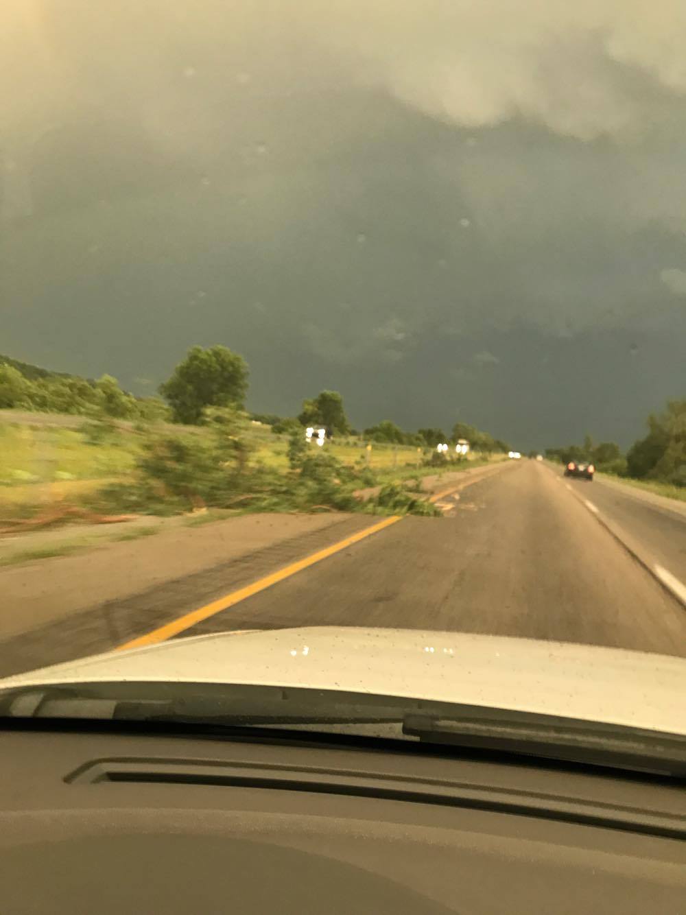
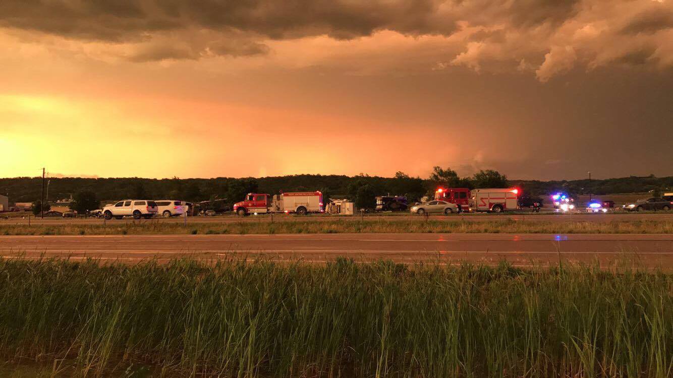
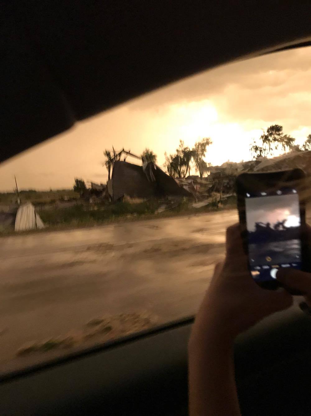
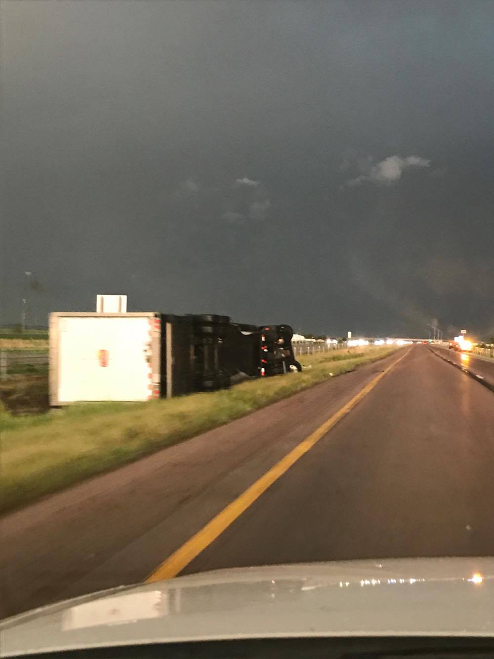
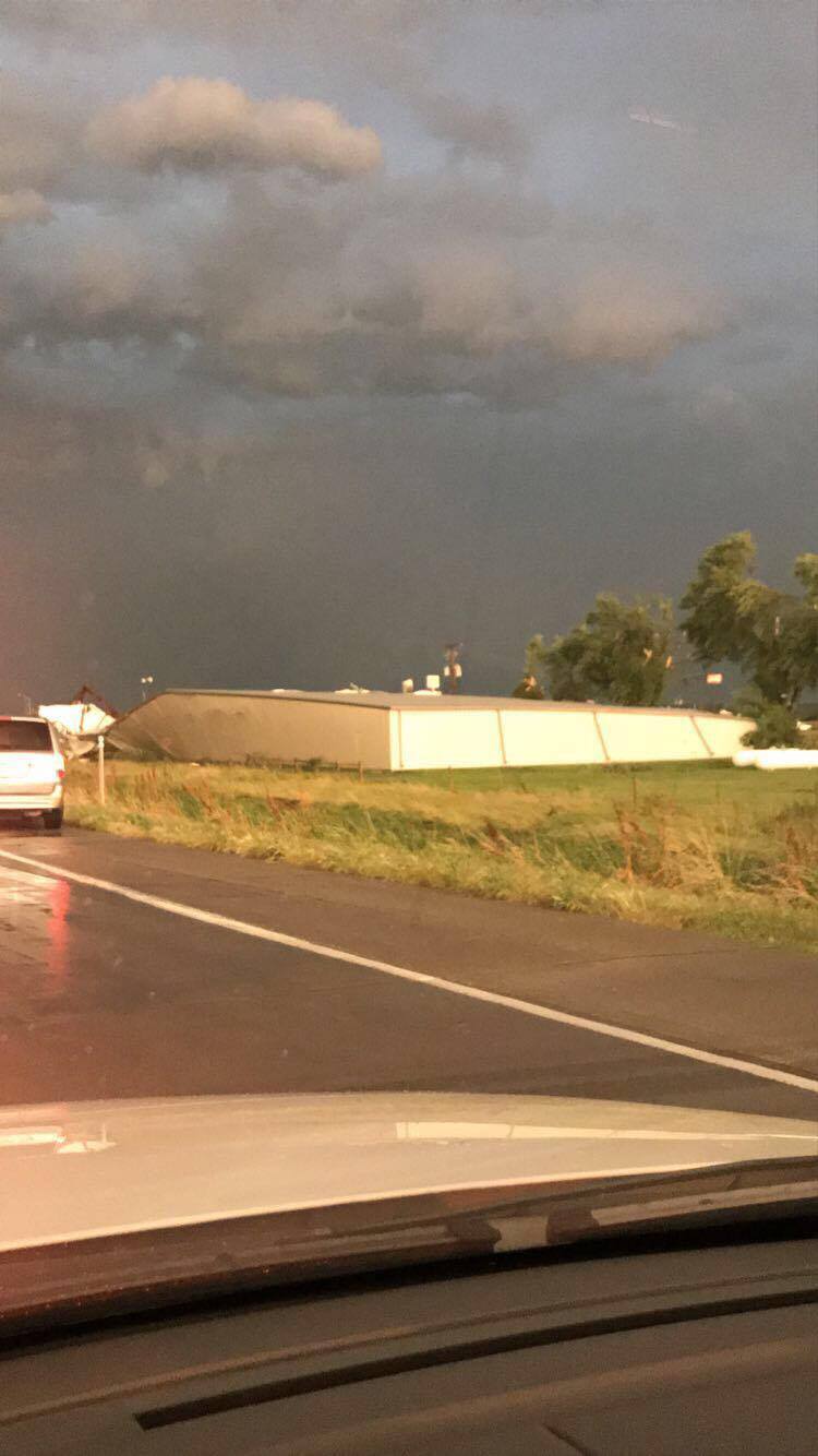
Some photos of damage taken along I-29 near the Highway 34 intersection (west of Glenwood). Photos courtesy Quinn Hall, from Red Oak.
10:00-p.m. Mid-American Energy reported 6, 743 customers were without power in the Council Bluffs service area, including: 1,697 in Mills County (1,755 in Glenwood alone); 1,103 in Shenandoah; 885 in Clarinda; 201 in Elliott; 245 in Pacific Junction; 186 in Page County and 173 in Pottawattamie County.
9:42-p.m. 1 person suffered minor injuries, 3 unsecured camper trailers were blown from camp site into the lake 4 miles east of New Market, in Taylor County.; Heavy (3″) rain reported in Sidney, IA.
9:36-p.m. 4 miles S. of Corning: reports of non-specific building damage near the Adams/Taylor county line. also numerous trees down around the county. Damage was most extensive in the southern portion of the county; Tree limbs and power lines down in Corning.
9:15-p.m. Alliant Energy reported 250 customers were without service in southern Cass County.
9:05-p.m. Trees and power lines down in Grant.
9:01-p.m. A trained storm spotter reported a 60mph gust of wind in Griswold.
8:55-p.m. Broken trees branches little the trees, power outages reported in Lewis.
8:50-p.m. Broken tree branches and power lines down in Griswold.
8:49-p.m. Several trees down after estimated 60mph wind 3 miles east of Thurman.
8:38-p.m. Large trees on the road 3 miles west of Oakland. Power lines down.
8:35-p.m. 62mph wind gust at the Harlan Municipal Airport.
8:35-p.m. Very large trees blocking the road 2 miles south of Thurman.
8:15-p.m. Large trees blown down, windows on a house broken 3 miles w. of Pacific Junction.
8:00-p.m. Roof damaged from 5″ diameter tree limb blown onto a home.
7:55-p.m. Roof blown off industrial bldg in Woodbine. Widespread tree damage in and west of town.
7:40-p.m. 60mph wind gust at Little Sioux in Harrison County.
BULLETIN – EAS ACTIVATION REQUESTED
Tornado Warning
National Weather Service Omaha/Valley Nebraska
829 PM CDT FRI JUN 16 2017
The National Weather Service in Omaha has issued a
* Tornado Warning for…
Western Montgomery County in southwestern Iowa…
Northeastern Mills County in southwestern Iowa…
Southeastern Pottawattamie County in southwestern Iowa…
* Until 900 PM CDT
* At 828 PM CDT, severe thunderstorms capable of producing both
tornadoes and extensive straight line wind damage were located 5
miles northeast of Glenwood, or 21 miles southeast of Omaha, moving
east at 35 mph.
HAZARD…Tornado.
SOURCE…Radar indicated rotation.
IMPACT…Flying debris will be dangerous to those caught without
shelter. Mobile homes will be damaged or destroyed.
Damage to roofs, windows, and vehicles will occur. Tree
damage is likely.
* These dangerous storms will be near…
Emerson around 850 PM CDT.
Red Oak around 900 PM CDT.
Other locations impacted by this tornadic thunderstorm include
Hastings, Silver City and Henderson.
This includes the following highways…
Highway 34 in Iowa between mile markers 14 and 36.
Highway 59 in Iowa between mile markers 28 and 41.
PRECAUTIONARY/PREPAREDNESS ACTIONS…
TAKE COVER NOW! Move to a basement or an interior room on the lowest
floor of a sturdy building. Avoid windows. If you are outdoors, in a
mobile home, or in a vehicle, move to the closest substantial shelter
and protect yourself from flying debris.
Mills IA-Pottawattamie IA-Sarpy NE-Douglas NE-
826 PM CDT FRI JUN 16 2017
The National Weather Service in Omaha has issued a
* Flood Advisory for…
Northwestern Mills County in southwestern Iowa…
Southwestern Pottawattamie County in southwestern Iowa…
Sarpy County in east central Nebraska…
Douglas County in east central Nebraska…
* Until 930 PM CDT
* At 825 PM CDT, Doppler radar indicated heavy rain due to
thunderstorms moving through the area. This will cause minor
flooding in the advisory area, especially in urban areas. One to
two inches of rain have already fallen.
* Some locations that will experience flooding include…
Omaha, Council Bluffs, Bellevue, Papillion, La Vista, Ralston,
Gretna, Springfield, Underwood, Waterloo, Elkhorn, Offutt AFB,
Millard, Carter Lake, Bennington, Boys Town, Crescent, McClelland,
Lake Manawa State Park and Koa Campground.
BULLETIN – EAS ACTIVATION REQUESTED
Severe Thunderstorm Warning
National Weather Service Omaha/Valley Nebraska
814 PM CDT FRI JUN 16 2017
The National Weather Service in Omaha has issued a
* Severe Thunderstorm Warning for…
Montgomery County in southwestern Iowa…
Mills County in southwestern Iowa…
Shelby County in southwestern Iowa…
Fremont County in southwestern Iowa…
Pottawattamie County in southwestern Iowa…
Eastern Harrison County in southwestern Iowa…
Page County in southwestern Iowa…
Northeastern Lancaster County in southeastern Nebraska…
Northeastern Nemaha County in southeastern Nebraska…
Southeastern Douglas County in east central Nebraska…
Southeastern Saunders County in east central Nebraska…
Sarpy County in east central Nebraska…
Eastern Otoe County in southeastern Nebraska…
Cass County in southeastern Nebraska…
* Until 845 PM CDT
* At 814 PM CDT, severe thunderstorms were located along a line
extending from 5 miles east of Persia to Treynor to 3 miles
southeast of Pacific Junction to 4 miles southwest of Elmwood,
moving southeast at 45 mph.
These are very dangerous storms.
HAZARD…80 mph wind gusts.
SOURCE…Radar indicated.
IMPACT…Flying debris will be dangerous to those caught without
shelter. Mobile homes will be heavily damaged. Expect
considerable damage to roofs, windows, and vehicles.
Extensive tree damage and power outages are likely.
* Locations impacted include…
Southeastern Omaha, Council Bluffs, Bellevue, Papillion, Nebraska
City, Plattsmouth, Red Oak, Clarinda, Glenwood, Shenandoah, Harlan,
Ashland, Springfield, Oakland, Villisca, Hamburg, Malvern, Sidney,
Louisville and Weeping Water.
This includes the following highways…
Highway 136 in Nebraska between mile markers 238 and 240.
Highway 2 in Nebraska between mile markers 493 and 508.
Highway 34 in Iowa between mile markers 1 and 51.
Highway 59 in Iowa between mile markers 1 and 80.
Highway 75 in Nebraska between mile markers 35 and 88.
Interstate 29 between mile markers 1 and 56.
Interstate 80 in Iowa between mile markers 1 and 48.
Interstate 80 in Nebraska between mile markers 414 and 430, and
between mile markers 452 and 454.
PRECAUTIONARY/PREPAREDNESS ACTIONS…
For your protection move to an interior room on the lowest floor of a
building.
BULLETIN – EAS ACTIVATION REQUESTED
Tornado Warning
National Weather Service Omaha/Valley Nebraska
807 PM CDT FRI JUN 16 2017
The National Weather Service in Omaha has issued a
* Tornado Warning for…
Northeastern Fremont County in southwestern Iowa…
West central Montgomery County in southwestern Iowa…
Mills County in southwestern Iowa…
Northeastern Sarpy County in east central Nebraska…
Northeastern Cass County in southeastern Nebraska…
* Until 830 PM CDT
* At 806 PM CDT, severe thunderstorms capable of producing both
tornadoes and extensive straight line wind damage were located over
Offutt AFB, or 12 miles south of Omaha, moving southeast at 45 mph.
HAZARD…Tornado.
SOURCE…Radar indicated rotation.
IMPACT…Flying debris will be dangerous to those caught without
shelter. Mobile homes will be damaged or destroyed.
Damage to roofs, windows, and vehicles will occur. Tree
damage is likely.
* These dangerous storms will be near…
Plattsmouth around 810 PM CDT.
Pacific Junction around 815 PM CDT.
Glenwood around 820 PM CDT.
Malvern around 830 PM CDT.
Other locations impacted by this tornadic thunderstorm include
Hastings, Silver City, Imogene, Camp Maha, Randolph and Tabor.
This includes the following highways…
Highway 34 in Iowa between mile markers 1 and 27.
Highway 59 in Iowa between mile markers 25 and 31.
Highway 75 in Nebraska between mile markers 73 and 85.
Interstate 29 between mile markers 27 and 42.
PRECAUTIONARY/PREPAREDNESS ACTIONS…
TAKE COVER NOW! Move to a basement or an interior room on the lowest
floor of a sturdy building. Avoid windows. If you are outdoors, in a
mobile home, or in a vehicle, move to the closest substantial shelter
and protect yourself from flying debris.


