
Atlantic (KJAN), 1.6”
Atlantic (7.1 miles N/NE) – Delbert Westphalen, 1.3”
Carroll, .29″
Manning, .85″
Massena, 1.12″
Mondamin, .94”
Mo. Valley, 1.49”
Elk Horn, 1.17”
Creston, .06”
Council Bluffs (2.1 miles S/SE), .07”
Schleswig, 1.39″
Dunlap, .91″
Persia, 1.9″
Earlham, 2.55″
Oakland, .77″
Kirkman, 1.55″
Earling, 1.25″
**A Severe Thunderstorm Watch remains in effect until 4-a.m.**Flood Watch until 7-a.m.**
Today: Cloudy this morning w/a 50% chance of showers & thunderstorms; Gradually becoming mostly sunny, with a high near 82. East wind 5 to 10 mph becoming north in the afternoon. New rainfall amounts between a quarter and half of an inch possible.
Tonight: A 40% chance of showers & thunderstorms; Partly cloudy, with a low around 64. North wind 5-10 mph.
Tomorrow: A slight chance of showers & thunderstorms early; gradually becoming sunny, with a high near 80. North northwest wind 5 to 10 mph.
Tom. Night: Mostly clear, with a low around 60.
Sunday: Sunny, with a high near 83.
Sunday Night: Mostly clear, with a low around 66.
Monday: Sunny, with a high near 88.
Thursday’s High in Atlantic was 86 and the Low was 65. We received 1.6″ of rain over the past 24-hours (ending 7-a.m. today).
The following are reports from the National Weather Service offices in Omaha and Des Moines:
..TIME...   ...EVENT...      ...CITY LOCATION...     ...LAT.LON...
..DATE...   ....MAG....      ..COUNTY LOCATION..ST.. ...SOURCE....
            ..REMARKS..
1235 AM     Tstm Wnd Dmg     4 NNW Arispe            41.00N 94.26W
07/08/2025                   Union              IA   Public
            4 inch diameter tree limb snapped. Delayed
            report relayed through social media. Time
            estimated by radar.
1213 AM     Tstm Wnd Dmg     Exira                   41.59N 94.88W
07/11/2025                   Audubon            IA   Trained Spotter
            Healthy, mature tree knocked over. Numerous
            large 6+ diameter limbs snapped off also.
1216 AM Tstm Wnd Dmg Lenox 40.88N 94.56W 07/08/2025 Taylor IA Public Several trees snapped and uprooted. Delayed report relayed through social media. Time estimated by radar.
1223 AM Tstm Wnd Dmg Bedford 40.67N 94.72W 07/08/2025 Taylor IA Public Top of mature tree snapped. Delayed report relayed through social media. Time estimated by radar.
1150 PM Tstm Wnd Dmg Guthrie Center 41.68N 94.50W 07/10/2025 Guthrie IA Trained Spotter Large tree limb down.
1145 PM     Tstm Wnd Dmg     Greenfield              41.31N 94.46W
07/10/2025                   Adair              IA   Emergency Mngr
            Tree damage across much of the city.
1145 PM     Tstm Wnd Dmg     Menlo                   41.52N 94.40W
07/10/2025                   Guthrie            IA   Emergency Mngr
            Tree damage across much of the area.
1049 PM Tstm Wnd Gst 5 S Harlan 41.58N 95.34W 07/10/2025 M68 MPH Shelby IA AWOS
(Radio Iowa) – Drought conditions continue to improve in the state. The latest U-S Drought Monitor shows most of the middle of the state has no drought conditions, which is about 64 percent — and is up from 57 percent last week. Less than four percent of the state has areas of moderate drought, including one county in northwest Iowa, six in the southeast, four in south-central, and two in eastern Iowa.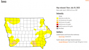
Around 36 percent of the state is abnormally dry, in sections along the eastern and western edges. Just 20 percent of the state had no drought conditions at the start of the year.
Official reports from NWS Cooperative Weather Observers:
Atlantic (KJAN), .22″
Atlantic (7.1 miles N/NE), .15″
College Springs, .17″
Council Bluffs (2.1 miles S/SE), 1.38″
Creston (8.3 miles W/NW), .22″
Earling, .35″
Elk Horn, .65″
Emerson (3.2 miles NE), 1.23″
Massena, .38″
Missouri Valley, 1.24″
New Market (4.7-miles North), .6″
Thurman (7.1 miles S/SE), .28″
Woodbine, .08″
Other, unofficial rainfall reports (to area media, etc.):
Anita, .12”
Atlantic (Downtown), .29”
Atlantic (southern City limits), .3”
Audubon, .08”
SE of Bridgewater, .4”
Corning, .35”
Glenwood, .2”
Griswold, .45”
Guthrie Center, 1.6”
Lenox, .3”
North of Neola, .41”
Oakland, .85”
Red Oak, .25”
Shenandoah, .47”
Stanton, .39”
Villisca, .21”
Storm damage reports:
Today: Showers & thunderstorms ending this morning; Partly sunny & breezy, with a high near 87. Winds South @ 10-20 mph w/gusts to near 25.
Tonight: Showers & thunderstorms likely, mainly after midnight. Low around 70. S/SE winds 10-20 mph. New rainfall amounts between three quarters and one inch possible.
Friday: Mostly cloudy w/a 70% chance of showers & thunderstorms. A high near 85. S/SE winds 5-10 mph. New rainfall amounts between a half and three quarters of an inch possible.
Fri. Night: Showers and thunderstorms likely, mainly before 7pm. Mostly cloudy, with a low around 65.New rainfall amounts between a quarter and half of an inch possible.
Saturday: A slight chance of afternoon showers & thunderstorms; Mostly sunny, with a high near 80.
Saturday Night: Partly cloudy, with a low around 60.
Sunday: Sunny, with a high near 83.
Wednesday’s high in Atlantic was 86. The Low was 64. We received .22″ rain early this morning, at KJAN. Last year on this date, the High in Atlantic was 84 and the Low was 58. The Record High for July 10th in Atlantic, was 104 in 1930 & 1936. The Record Low was 46 in 1895 & 1996. Sunrise: 5:55; Sunset: 8:55.
Today: Patchy fog this morning; Mostly sunny, with a high near 86. Calm wind becoming south at around 5 mph this afternoon.
Tonight: A 40% chance of showers & thunderstorms after midnight. A low around 66. SE wind around 5 mph. New rainfall amounts between a tenth and quarter of an inch, except higher amounts possible in thunderstorms.
Tomorrow: A 40% chance of showers & thunderstorms, mainly before 1pm; Partly sunny. High near 84. S/SE @ 5-15 mph w/gusts to around 20 mph. New rainfall amounts of less than a tenth of an inch, except higher amounts possible in thunderstorms.
Tom. Night: A 50% chance of showers & thunderstorms. Low around 68. New rainfall amounts between a half and three quarters of an inch possible.
Friday: Showers likely & thunderstorms likely. A high near 82. New rainfall amounts between a quarter and half of an inch possible.
Fri. Night: Partly cloudy w/a slight chance of showers & thunderstorms. Low around 61.
Saturday: Mostly sunny, with a high near 79.
Tuesday’s high in Atlantic was 85. Our Low this morning was 62. Last year on this date, the High in Atlantic was 86 and the Low was 60. The Record High for July 9th in Atlantic, was 104 in 1930. The Record Low was 37 in 1895. Sunrise: 5:54; Sunset: 8:55.
OFFICIAL rainfall reports (From NWS Cooperative Observers):
Atlantic (KJAN), 1.08″
Atlantic (7.1 miles N/NE), 1.12″
College Springs, 1.06″
Council Bluffs (2 reports: 2.1 miles S/SE, .8″; 1.5 miles E, 1.45″),
Creston, .64″ (8.3 miles NW of town)
Earlham, .47″
Earling, 1.98″ (2.4 miles SE)
Elk Horn, 1.72″
Emerson, .66″
Imogene, .75″ (2.7 miles N/NE)
Kirkman, .96″
Logan, 1.89″
Manning, .91″
Massena, .74″
Missouri Valley, 1.23″ (2.1 miles NE)
Missouri Valley, 1.43′ (6.3 miles E/NE)
Mondamin, 1.27″
New Market, 1.05″
Oakland, .51″ (3.2 miles N/NE)
Pacific Junction, .02″ (3.9 miles N)
Persia, 1.47″
Dallas Center (Dallas County), 2.17″
Truro (Madison County), 1.34″
Other (Unofficial/media) rainfall reports:
Anita, 1.5″
Downtown Atlantic, 1.9″
Audubon, .7″ (Sam Kauffman)
Clarinda, 1.25″
Corning, 1.45″
Creston, .4″
Exira, 1.25″
Glenwood, .8″
Griswold, 1.45″
Guthrie Center, 1.6″
Hancock, 1.5″
Harlan (KNOD), 1.03″
SE of Irwin, 1.48″
Kirkman, 1.01″
Marne, 1.3″
Oakland, 1.5″
Red Oak, .55″
Shenandoah, .7″
Today: (Updated 4:45-a.m.) Any showers will be ending this morning; Gradually becoming mostly sunny. A high near 83. Winds NW @ around 5 mph.
Tonight: Mostly clear, with a low around 63.
Tomorrow: Sunny, with a high near 86. S/SW winds 5 mph.
Tom. Night: Partly cloudy w/a slight chance of showers & thunderstorms after midnight. Low around 66. SE @ 5 mph.
Thursday: Partly sunny w/a 30% chance of showers & thunderstorms. High near 84.
Thu. Night: A 50% chance of showers and thunderstorms. A low around 67.
Friday: Mostly cloudy w/a 60% chance of showers and thunderstorms, mainly during the afternoon. A high near 83.
Monday’s high in Atlantic was 88. Our Low this morning was 65. Rainfall in Atlantic late Monday night into early this morning, at KJAN, was 1.08″. Last year on this date, the High in Atlantic was 83 and the Low was 58. The Record High for July 8th in Atlantic, was 102 in 1937. The Record Low was 42 in 1908. Sunrise: 5:53; Sunset: 8:56.
Here are some storm reports from the National Weather Service, with regard to the storms that moved through western Iowa overnight Monday into early Tuesday morning. Thunderstorm warnings were issued for Cass, along with parts of Adams and Adair Counties, at 11:20-p.m. Winds gusting to just under 60-mph were recorded at the Automated Weather Observation Site (AWOS) at the airport in Atlantic, at 11:15-p.m.
Power outages were reported in Griswold late Monday night. Thousands were without power early Tuesday morning in the Omaha/Council Bluffs metro area. As of 3:25-a.m., the Iowa REC reported 6 outages in parts of Pottawattamie, Cass and Adams Counties. Mid-American Energy reported over 500 of its customers in central Iowa were without electricity early Tuesday morning, as well.
..TIME...   ...EVENT...      ...CITY LOCATION...     ...LAT.LON...
..DATE...   ....MAG....      ..COUNTY LOCATION..ST.. ...SOURCE....
            ..REMARKS..
1210 AM     Tstm Wnd Gst     2 W Lenox               40.89N 94.61W
07/08/2025  M60 MPH          Taylor             IA   Public (PWS)

1132 PM     Tstm Wnd Gst     5 NNE Villisca          41.01N 94.95W
07/07/2025  M61 MPH          Montgomery         IA   Public (PWS)
1124 PM Tstm Wnd Gst 5 SE Griswold 41.20N 95.06W 07/07/2025 M58 MPH Cass IA Public
(Personal Weather Station)
1050 PM Tstm Wnd Gst 4 NNE Emerson 41.07N 95.38W 07/07/2025 M56 MPH Mills IA Mesonet
1015 PM     Tstm Wnd Gst     5 SW Mcclelland         41.28N 95.75W
07/07/2025  M60 MPH          Pottawattamie      IA   Mesonet
1012 PM     Tstm Wnd Dmg     Council Bluffs          41.24N 95.86W
07/07/2025                   Pottawattamie      IA   Public
            Large Branches down.


