
(Omaha, Nebraska) – Weather bulletins for severe thunderstorms were issued by the National Weather Service in Omaha, early today (Monday) for parts of eastern Nebraska, western and southwest Iowa. The storms packed radar-estimated winds of 60-to 70-miles per hour.
At around 3:20-a.m., law enforcement in Harrison County reported thunderstorm winds tore the off of a home in Mondamin.The last warning issued for the area expired prior to 4:30-a.m.
Today: Showers and thunderstorms before 8am; Sunny, with a high near 94. EXTREME HEAT WARNING from Noon until 8-p.m. Heat index values as high as 109. Winds South at 5 to 10 mph.
Tonight: Mostly clear, with a low around 71. South wind 5 to 10 mph.
Tomorrow: Mostly sunny, with a high near 91. S/SE winds 5-10. Heat index values as high as 102.
Tom. Night: A 50% chance of showers & thunderstorms, mainly after 1am. Low around 68.
Wednesday: Showers and thunderstorms. A high near 77.
Wed. Night: A chance of showers & thunderstorms. Low around 62.
Thursday: Mostly sunny, with a high near 76.
Sunday’s High in Atlantic was 92. Our Low this morning, 68. As of 5-a.m. in Atlantic, we received .09 rain this morning at KJAN. Last year on this date, the High in Atlantic was 88 and the Low was 68. The Record High in Atlantic on July 28th was 105 in 1935. The Record Low was 43 in 2013. Sunrise today: 6:11; Sunset tonight: 8:42.
Today: Sunny, with a high near 92. **HEAT ADVISORY from Noon until 8-p.m.** Heat index values as high as 105-110 degrees. Wind South @ 5-10 mph in the morning.
Tonight: Mostly clear, with a low around 73. South wind 10- 20 mph.
Monday: Sunny, with a high near 95. Heat index values as high as 109. S/SW wind 5-10 mph.
Monday Night: Mostly clear, with a low around 71. South wind 5 mph.
Tuesday: Mostly sunny, with a high near 93.
Tue. Night: A 50% chance of showers & thunderstorms, mainly after 1am. A low around 68.
Wednesday: A 60% chance of showers, and possible thunderstorms. High near 77.
Saturday’s High in Atlantic was 89. Our Low this morning, 67. We had a Trace of rain Saturday morning at KJAN. Last year on this date, the High in Atlantic was 88 and the Low was 69. The Record High in Atlantic on July 27th was 105 in 1930. The Record Low was 41 in 2013. Sunrise today: 6:10; Sunset tonight: 8:43.
Today: Mostly cloudy this morning w/a slight chance of showers & thunderstorms before 7am. Gradually becoming sunny, with a high near 85. South wind around 5 mph.
Tonight: Mostly clear, with a low around 70.
Tomorrow: Sunny, with a high near 92. EXTREME HEAT WATCH in effect from Noon until 8-p.m for heat index values as high as 106. S/SE-S winds 5 to 10 mph in the morning.
Tom. Night: Mostly clear, with a low around 74. South wind 5 to 10 mph.
Monday: Sunny, with a high near 95.
Monday Night: A slight chance of showers and thunderstorms after midnight. A low around 72.
Tuesday: A slight chance of afternoon showers and thunderstorms; Mostly sunny, with a high near 92.
Friday’s High in Atlantic was 85. The Low was 70. Last year on this date, the High in Atlantic was 89 and the Low was 69. The Record High in Atlantic on July 26th was 109 in 1936. The Record Low was 43 in 1962. Sunrise today: 6:09; Sunset tonight: 8:44.
Today: Patchy fog before 10-a.m.; Mostly cloudy w/a sight chance evening showers & thunderstorms (after 5-p.m.). A high near 83. E/SE breeze at 5-10 mph this morning.
Tonight: A 40% chance of showers & thunderstorms, mainly after 8pm. Some of the storms could produce heavy rainfall. Low around 69. New rainfall amounts between three quarters and one inch possible.
Saturday: Cloudy in the morning w/a 30% chance of showers & thunderstorms, mainly before 7am. Gradually becoming mostly sunny, with a high near 86. South wind 5 to 10 mph. New rainfall amounts between a tenth and quarter of an inch, except higher amounts possible in thunderstorms.
Saturday Night: Mostly clear, with a low around 71. South wind around 5 mph.
Sunday: Sunny, with a high near 92.
Sunday Night: Mostly clear, with a low around 73.
Monday: Sunny, with a high near 94.
Monday Night: Mostly clear, with a low around 72.
Tuesday: Mostly sunny, with a high near 90.
Thursday’s High in Atlantic was 83. The Low was 68. Last year on this date, the High in Atlantic was 89 and the Low was 69. The Record High in Atlantic on July 25th was 117 in 1936 (That was also the ALL-TIME Record High ever recorded in Atlantic). The Record Low was 44 in 1894. Sunrise today: 6:07; Sunset tonight: 8:44.
(Radio Iowa) – Today’s (Thursday) updated Drought Monitor report shows Iowa is close to being drought free. The U-S Drought Monitor map shows only about four percent of the state now has drought conditions. Most of Wappello County still has moderate drought, with some across the county line into Monroe and Davis County in southeast Iowa. There’s also some abnormally dry conditions in those counties. A sliver of moderate drought is hanging on in southwest Iowa, along the western edge of Mills County. 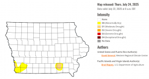
There’s some abnormally dry conditions in nearby Fremont and Page counties. The year started with 94 percent of the state with some type of drought condition.
Official reports from National Weather Service Cooperative Observers:
Atlantic (KJAN), .64″
Atlantic (7.1 miles N/NE), .52″
Creston (8.3 miles W/NW), .80″
Council Bluffs (2.1 miles S/SE), .35″
Dunlap (5.4 miles N/NW), .88″
Earling (2.4 miles SE), .60″
Elk Horn (.2 mile S/SE), .49″
Emerson (3.2 miles NE), 1.49″
Hastings (1.5 miles NW), 1.00″
Kirkman, 1.00″
Manning, .86″
Massena, .73″
Missouri Valley (2.1 miles N/NE), .40″
New Market (4.7 miles N), .65″
Pacific Junction (3.9 mile N), .96″
Thurman (7.1 miles S/SE), 2.89″
Woodbine, .76″
Other, unofficial reports:
Anita & Audubon, .50″ each
NW of Avoca, .90″
Bridgewater, 1.00″; (SE of Bridgewater, .80″)
Clarinda, .95″
Harlan, 1.30″
Lenox, 1.25″
Marne, .75″
North of Neola, .75″
Shenandoah, 1.73″
Stanton, 1.12″
Villisca, .50″
..TIME...   ...EVENT...      ...CITY LOCATION...
..DATE...   ....MAG....      ..COUNTY LOCATION..ST.. ...SOURCE....
            ..REMARKS..
1236 AM Tstm Wnd Gst Bagley E75 MPH Guthrie IA Emergency Mngr
1214 AM Tstm Wnd Gst 1 NW Coon Rapids M82 MPH Carroll IA Mesonet Measured by personal weather station near intersection of storms along pre-existing outflow boundary.
1204 AM Tstm Wnd Gst 2 S Willey M67 MPH Carroll IA Mesonet measured by personal weather station.
Today: Showers ending this morning, w/a 40% chance of showers & thunderstorms again this afternoon. Mostly cloudy. A high near 82. Winds South @ 5-10 this morning switching to the North this afternoon. New rainfall amounts of less than a tenth of an inch, except higher amounts possible in thunderstorms.
Tonight: A 50% chance of showers & thunderstorms. A low around 69. New rainfall amounts of less than a tenth of an inch, except higher amounts possible in thunderstorms.
Friday: A 60% chance of showers & some thunderstorms. High near 80. East wind 5 to 10 mph. New rainfall amounts between a tenth and quarter of an inch, except higher amounts possible in thunderstorms.
Fri. Night: A 50% chance of showers & thunderstorms. Low around 68. New rainfall amounts between a quarter and half of an inch possible.
Saturday: Mostly sunny, with a high near 87.
Saturday Night: Mostly clear, with a low around 70.
Sunday: Sunny, with a high near 93.
Wednesday’s High in Atlantic was 90. The Low was 69. We received .64″ rain overnight in Atlantic, at KJAN. Last year on this date, the High in Atlantic was 88 and the Low was 61. The Record High in Atlantic on July 24th was 110 in 1901. The Record Low was 42 in 1905. Sunrise today: 6:06; Sunset tonight: 8:45.
Today: **HEAT ADVISORY IN EFFECT FROM NOON UNTIL 8-PM for heat index values as high as 105 degrees** Sunny, breezy & hot. A high near 93. Heat index value around 103. Winds South at 10-20 mph gusting to near 25. Hot temperatures and high humidity may cause heat illnesses. Drink plenty of fluids, stay in an air-conditioned room, stay out of the sun, and check up on relatives and neighbors.
Tonight: Increasing cloudiness w/a 60% chance of showers & thunderstorms, mainly after midnight. Low around 70. Wind S @ 10-20 mph. New rainfall amounts between a quarter and half of an inch possible.
Tomorrow: Showers & thunderstorms likely, mainly before 7-a.m & then again after 1-p.m; Mostly cloudy. A high near 84. S/SW Winds 5-10 becoming N/NW in the afternoon. New rainfall amounts between a tenth and quarter of an inch, except higher amounts possible in thunderstorms.
Tom. Night: A 30% chance of showers & thunderstorms. A low around 68.
Friday: A 40% chance of showers & thunderstorms. High near 83.
Friday Night: A 30% chance of showers & thunderstorms through midnight. A low around 68.
Saturday: Mostly sunny, with a high near 88.
Tuesday’s High in Atlantic was 87. The Low was 73. Last year on this date, the High in Atlantic was 85 and the Low was 60. The Record High in Atlantic on July 23rd was 105 in 1901. The Record Low was 45 in 1904 & 1956. Sunrise today: 6:05; Sunset tonight: 8:46.


